
Whenever we've read articles about crossing the Great Australian Bight or spoken to people about it, the advice has universally been “wait for a weather window and get across as quickly as you can.” Then we happened to meet a fisherman who'd spent years in the Bight and his recommendation was quite different. “Don't be afraid to get up into the Bight”, he said. “It's a beautiful area and there are places that you can anchor to protect yourself from the winds.” We started to think about things a little differently. Though we were obviously keen to get across safely, we’ve never been known to hurry, so we looked into the possibilities.
It's not that we didn't trust the word of many, but listening to the fisherman's advice was compelling; it made sense. We wouldn't require such a long weather window to cross, the passage could be broken up into shorter overnight legs and we'd actually see something of the Bight's beauty along the way. We did a bit more research. We read. We perused the Western Australia Cruising Guide, but it offered little detail on anchorages in the northern part of the Bight. We talked to more folks about trying a different approach to the Bight crossing. Some had crossed the Bight before; some had not. They all agreed, however. “It's the Southern Ocean,” they said. “Just get across.” Some told us to go as far north and west as Ceduna as a jumping off point. Others thought just sailing directly from Port Lincoln made more sense, just to get it over with. We opted to leave from Streaky Bay. Whether you're jumping off to cross the Bight or arriving from the west, there's not a more beautiful place.

Nine of cups' route across the bight
We started out slow and easy with a 50nm passage to St. Francis Island on advice from some local sailors. The passage was great until the clew ripped out of our 2-year old yankee foresail in a paltry 20-knot gust. We barely got the yankee furled as much as we could when we were “attacked” by a series of vicious roll clouds aka morning glories that spawned 35+ knot gusts. With only a postage stamp of a loose foresail flapping in the wind, we couldn't get our new anchor to set properly in the weedy-bottom of the St. Francis anchorage. Typical of calamities at sea, they all seem to come at once when you're the most tired and aggravated. In the lea of the island, we finally managed to get the foresail down and clumsily stuffed into a sailbag, the anchor finally caught and the roll clouds headed east to attack some other unsuspecting sailors.
We waited out two days of strong southwesterlies, then with east winds forecast, a spare genoa on the forward furler and better dispositions, we headed not straight southwest across the Bight, but rather west to Eucla. Looking at Eucla on our chartplotter, we saw nothing but open bay. Our fisherman friend, however, had provided us with a hand drawn chart of the entrance to the anchorage behind shallows and sand bars. We entered at Long 129º where the color of the cliffs changed markedly from white to black and proceeded straight in till we were about a half mile from the shore, then turned due west and headed toward the old jetty, noted on the chart. The pale aquamarine water was considerably calmer than outside the anchorage and the sand bottom was a welcome sight. We dropped the hook and it dug in immediately. We heaved a sigh of relief. Before we could even tidy up the lines, swallows lined the whisker pole and rails and chirped us their welcomes.

Chartlet into eucla anchorage
The wind howled for the rest of the day from the S/SE, reaching 25-30 knots with gusts near 35 knots. We pitched a bit, but the the motion was certainly tolerable. The shallows and sand bars absorbed much of the wave action. We held firmly. I might add that we are a heavy-displacement boat (20 tons) and a smaller, lighter boat would most certainly have found the conditions less tenable.
The winds calmed during the night and with a beautiful day dawning, we launched the dinghy for a trip ashore. The walk along the fine, deep sand beach was challenging. The historic old jetty was totally dilapidated, its few remaining in-tact pilings lined with cormorants and gulls. We found a rough 4-wheel drive track leading across the bush and up towards the Eyre Highway. The flies were merciless which made photography a labor. David swatted while I snapped. An emu emerged from the bush and strolled across the road, apparently unconcerned with our presence.

the eucla jetty
We came across the crumbling remains of an old telegraph station, nearly engulfed in sand. It seems in the 1890s, a rabbit plague passed through the area and ate much of the dune vegetation, subsequently allowing sand dunes to encroach upon the town. The original town was abandoned, and a new townsite was established a few kilometers to the east, higher up on the escarpment. The telegraph station, a few leaning telegraph poles and one old foundation are all that's left.
About 3 miles in, parched and hungry, we climbed the hill to the Eucla Roadhouse, a welcome stop for those crossing the Nullarbor, as well as errant sailors. With a quick sandwich and a cold drink to sustain us, we headed to the tiny one-room museum which provided more info on the telegraph station, some local history and the tale of the infamous Nullarbor Nymph. As we exited the tiny museum, we met a woman who had been working in the restaurant. She asked if we were passing through and we told her we had sailed in and were anchored by the jetty. She perked right up. “We saw the sailboat anchored there and wondered who it was. We're lucky if we see one yacht anchored here a year.” She then proceeded to offer us a ride back to the boat. We gladly accepted her generous offer. We chatted as we drove and talked about heading perhaps to Twilight Cove, an anchorage we knew little about further up the coast. She stopped the car, turned around and headed back up the road to her home. Her partner, Paul, was a fisherman who had fished the Bight for the past 27 years. He could provide us some firsthand information about other anchorages in this part of the Bight. Talk about luck! Paul immediately produced a well-worn chart and his fishing notebook and proceeded to give us detailed information about Twilight Cove, Eyre and other anchorages including depths, lats/longs and hazards. It was like manna from heaven.
We took a ride part way back to the boat and when the going got rough, we opted to walk the rest of the way. We watched as the tops the sand dunes blew off in the ceaseless wind and drifted around us. All the while we made our way down the trail, we had Nine of Cups' mast in view. Though we wandered off the path occasionally, we headed for the mast and finally joined the sandy beach road which led to the jetty. The surf was up a bit and we were soaked through and through by the time we launched the dinghy and muddled through the rollers. We were tired, wet and exhilarated when we arrived at Cups. A fine day on the Nullarbor Plain and to top it off, the Eucla anchorage had an excellent Telstra internet signal!
Our conversation with Paul gave us the incentive and the information we needed to stray off the beaten path once again. David was looking at the proposed passage from Eucla to Daw Island, 300 nm, and wondered if there wasn't some way of breaking up the trip. Eyre was only 170nm … two days and an overnight. To add icing to the cake, the Eyre Bird Observatory there is the most isolated research facility in Australia and is home to 240 species of birds. Researching the Observatory on-line, David found an e-mail address for the volunteer caretakers, sent them an e-mail inquiring about the anchorage and lo and behold, we had an answer within hours. They actually got in touch with a local cray fisherman and were able to corroborate Paul's information about anchorage depths and entrance coordinates enabling us to maneuver around the sand bar and shallows that provide protection to the bay. The weather seemed to be cooperating and we were off.

chartlet for eyre anchorage
The passage from Eucla was a quick broad reach and the coordinates that our Eucla friend, Paul, and Vince the cray fishermen in Eyre provided were spot on. The landmark to look for on entry is the Eyre Sand Patch, a huge sand dune, noted and named by Edward John Eyre on his historical first trek across the Nullarbor and it's hard to miss.

Cups at anchor off eyre
Eyre is not a port, but rather an anchorage that a couple of cray fisher boats call home in season. Other than the Eyre Bird Observatory, the closest neighbor is the Cocklebiddy Roadhouse about 30 miles away and access to the Observatory off the Eyre Highway is 20 miles on a 4-wheel drive road that purportedly shakes your dental fillings loose. Or … you can arrive by sea, anchor in the backyard, dinghy ashore, walk a half a mile and call in for tea.
Despite the grey and overcast sky, we headed to shore the next morning. The sandy beach trail led through dunes, up a narrow, 4-wheel drive road and into a small, very green valley with lots of flora and birdsong. Signs and lengths of hawser marked the way. We could see the tin roof of the Observatory nestled in a little hollow as we crested the hill.
In 1977, Birds Australia established the Eyre Bird Observatory in the remains of the first Eyre Telegraph Station, a repeater station built in 1877, and replaced by the current limestone building in 1897. Beyond the birding aspects of The Observatory, there's a small museum in the house that features a display “commemorating the role the Telegraph Station had in establishing national communications in Australia along with Inter-Colonial Telegraph Line.” We shared a cuppa with our hosts, Kirsty and Gavin, on the veranda. They provided us with an introduction to the Observatory and then turned us loose to have a look around and explore several of the footpaths and tracks in the surrounding area.
As we walked, we felt protected by the huge dunes on the seaward side, but when the breezes became a bit brisk, we began worrying about the boat and returned to the station to say our farewells. We would have enjoyed several more of the illustrated walks in the area, but a brief visit was definitely better than no visit at all and we headed back along the sandy trail to a waiting Cups.
Getting back to the boat was no trivial affair. The wind was up and with it, the surge. We dragged the dinghy into the water, keeping it straight into the waves as they broke. When we were near thigh-deep, we timed the waves and when there appeared a short respite, I jumped into the bow and began paddling like mad and with a shove, David jumped in over the stern, losing his shoes and taking up a paddle in one swift motion. We thought we were good and David stopped paddling to start the engine. A wave larger than the rest caught us, pooped the dinghy, and turned us broadside to the next wave which carried us with some alacrity back to the shore. So, the process repeated and repeated. Finally, on our umpteenth try, we made it beyond the breakers and were on our way, rather tumultuously, back to Cups. We were wet through and through, dripping and totally bedraggled. Ah, but the saga did not end there.
Tying up the dinghy with the waves thrashing took two of us. Clambering aboard Cups from the jerking dinghy was not a graceful affair and still we had to haul the engine and get the dinghy aboard. David always takes the precaution of fastening a line to the engine and securing it to the boat, so we don't lose it overboard. It's never happened, but you never know. Especially in boisterous situations, I hold the line taut as he's loosening the engine bolts that secure it to the dinghy. Quicker than you can say, “Yikes, the engine's heading for the drink”, I was wrestling to keep hold of a 50-pound engine blowing in the breeze after it came loose from the dink. It dangled ever so closely to submersion level. David was up in a flash, hauled the engine and had it back in its mount and secure before any damage was done.
Now, it was time to haul the dinghy, always a challenge when the wind is up. In days past, I slowly winched up the 165 pound dinghy while David manhandled it into position and tried to keep it from beating up the boat or itself on its way up. With the new system David has devised, we use the windlass and a pulley system which gets it on board in a matter of a couple minutes. I'm pleased to report the dinghy was stowed in its place on the foredeck with no mishaps and only a few bruises. All chores complete, we were relieved to find that Cups was weathering the waves like a trooper. She was pitching a bit, but all in all, especially compared to the dinghy ride, she was quite comfortable and holding tight on her anchor. Warm, dry clothes and a hot coffee made everything okay.
Where to next? Daw Island was on the itinerary. The first question was “Where is Daw Island?” It was difficult to pin down its exact location. Our Australian paper charts gave the anchorage position at one location. Our Raymarine chartplotter showed the position of the anchorage about 3.75 nautical miles further east. We use Navionics Gold software on the chartplotter, but also have Navionics on our iPad. Even the Navionics software on the two devices differed. The satellite view provided by Google Earth gave the position of the anchorage about 0.25 nm west of the chartplotter location. We headed for the general location.

Daw island chartlet
The run from Eyre to Daw Island was quick and bumpy, 148nm in just over 22 hours. The SW swell coupled with a brisk east wind and corresponding waves, contributed the majority of the bumps. Considering we weren’t really sure exactly where Daw Island was, we were keen to approach it in daylight. There were several other low-lying islands and islets in the vicinity and since Daw was apparently mis-located on the charts, perhaps these were, too?
Other than the bumps, the passage was unremarkable except for a few ill-timed waves that hit us unexpectedly in the cockpit. One such wave caught me full face as I emerged from the galley with a hot cup of tea around 0230 and not only drenched me and the cockpit, but left a gift which we didn't discover until it came to light on David’s watch several hours later. A rather large squid had been deposited neatly on the bench behind the helm. His discontent with the situation was very evident … he’d inked us. Rigor had already started setting in, so no calamari for dinner, but he got rave reviews from the local shearwaters as David commended him to the sea. They fought over the goodie and then followed the “breakfast boat” for several miles before giving up on more treats.
It was a grey, grey dawn made duller by grey skies and a grey sea, with a kicker of a grey swell. An early morning mist, then rain, kept the suspense heightened since we never saw Daw until we were less than 10 nm away. Sticking out of the ocean nearly 300 feet, we finally spotted it, a shrouded hulk of an island. A multi-hued grey silhouette rose out of the sea, looming ominously, a darker grey cloud hovered over it. It looked like the home of some fairy tale witch or ogre. But a sea eagle soared overhead just then and dolphins joined us. How bad could it be?
At anchor off daw island
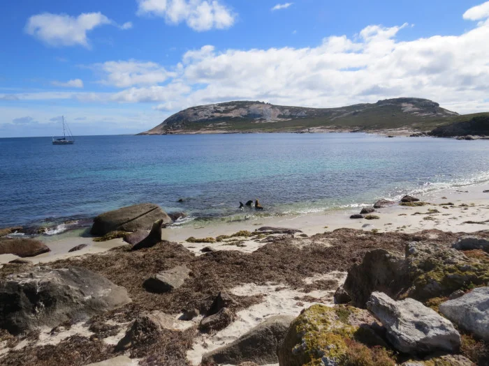
Just as we’d hoped, the island curved around, enveloping a lovely, millpond-calm anchorage. Bird sounds accentuated by the barks and yips of sea lions along the rocky shore greeted us. Despite the grey skies, sand patches were evident in the clear water and we dropped the pick in 25′ off a sandy beach and it hooked immediately.
The following morning was glorious. In a word, Daw Island is magic. We landed on the white sand beach as sea lions languished in the morning sun. They watched us warily and quickly headed for the water. More confident in the water, they followed our movements up and down the beach with curiosity. We had planned to hike to the high point for views, but were soon deterred by a faded, but clear warning sign: Death adders reside in large numbers on this island. So much for views … undoubtedly very overrated. We contented ourselves with beachcombing and walking the beach where gulls, terns, oystercatchers and Cape Barren geese seemed to be enjoying the morning sun as much as we were.
We considered Daw Island in the Eastern Recherche Group to be our last bit of the Bight. It had taken us 10 days and we sailed 628 nm. We had encountered no significant weather in our crossing. By going further up into the Bight, we had avoided the major impact of huge waves as they traveled over the deep terraces, canyons and troughs to the shallower Bight waters. We took our time and had the chance to visit places we would never have visited otherwise. All in all, it was quite an enjoyable passage. Admittedly, this type of crossing isn't for everyone, but quite honestly, crossing the Great Australian Bight isn't for everyone either. In retrospect, if we were to cross again, we'd opt to do it the same way.