

Blue View - Bike Routes Have Numbers?
/As we’ve been riding our bikes through Ohio, we’ve been noticing that all the bike trails in the state seem to have route numbers - and some have even more than one number. Is this an Ohio thing, our was I just totally oblivious to the signage in Pennsylvania, West Virginia and Maryland? Marcie doesn’t recall seeing bike route numbers elsewhere either, so I decided to do some research.


A little history:
Many countries around the world have networks of interconnected bike routes. The UK and the Netherlands are two good examples, as is the EuroVelo network that crisscrosses the European continent. With a similar goal of establishing a nationwide system of bike routes here, the United States Bicycle Route System (USBR) was established in 1978. The planned routes were to incorporate off-road trails when possible, but were also to include bicycle lanes and low-traffic roads.
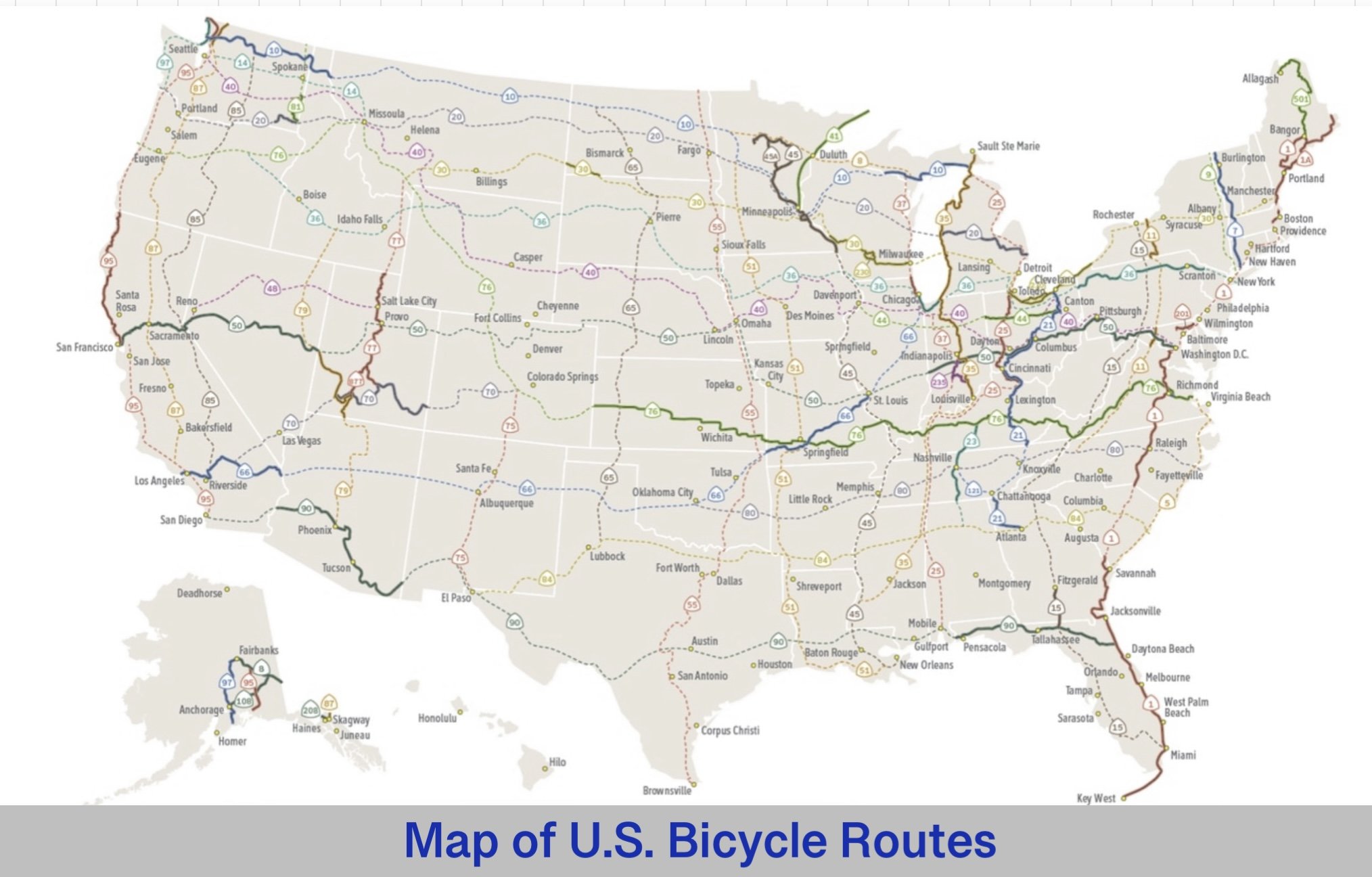
The USBR got off to a slow start - in the 14 years between 1978 and 1992, only two routes had been established, and for the next decade, the project was pretty much shelved. Renewed support began in the early 2000’s, however, and the next decade saw a great deal of planning and the completion of several new routes. The momentum continued… as of July, 2022, more than 55 routes totaling 18,534 miles, and crossing 33 states plus Washington D.C. have been completed.
The numbering system:
To identify all these routes, the USBR uses a numbering system similar to the U.S. highway numbering system. Cross-country routes are usually one or two digits. Even numbered routes run primarily east-west, with the lowest numbers in the north and the highest numbers in the south, while odd numbered routes run primarily north-south, with the lower numbered routes in the east. (Note that the USBR and the U.S. highway system differ from the Intestate highway numbering system. With the interstate highway system, the lower numbers are in the south, I-10 for example, and in the west, i.e. I-5).
Just as with the highway system, individual states and counties are responsible for maintaining the bike routes. The federal government does provide substantial funding to the states for road maintenance, however, but with the requirement that the states or counties provide an adequate number of signs marking the routes. Since little or no federal funding is provided to the states/counties for bike trail maintenance, they have less incentive to pay for all those USBR signs… so many just use the names of the individual trails, such as the Montour Trail or the Route of the Hiawatha.
Some states, like Ohio, not only mark all the USBR routes, but use a similar trail numbering system for bike routes within the state. For example, Ohio SBR 1 is a bike route that extends from Cleveland to Cincinnati, for a total of 326 miles. Also, much like the U.S. highway system, two or more bike routes may merge for awhile, like USBR 25 and USBR 225, or USBR 21 and Ohio SBR 1. Thus, as we bike along the Ohio-Erie Trail, we are likely to see USBR, SBR, and Ohio-Erie Trail signs, all marking the same route.
If all this seems confusing, it can be even more so as we’re biking along and come to a Y in the trail, with multiple trail markers pointing in both directions. More than once, I’ve led us astray, and had to backtrack. Depending on how tired we are at the time, and how big a hill we have to pedal back up to get back on the right trail, Marcie is usually quite unruffled.
By the way, Ohio claims to have the most miles of paved bike trails of any state… it certainly has the most number of USBR and SBR signs of any state we’ve cycled through.

Some really cool USBRs:
There aren’t any of the U.S. Bicycle Routes I wouldn’t want to ride, but there are some that would be especially cool to ride. On the maps below, the solid lines indicate the portions that are complete, while the dotted lines indicate the sections that are still in the planning phase.
USBR 1. One of the first two routes in the USBR system, this route runs from Calais, Maine to Key West at the end of the Florida Keys.

USBR 35. Another north-south route, this one travels from Sault Saint Marie on the Canadian border in Michigan’s upper peninsula to New Orleans.

USBR 76. The route number, 76, was chosen because this route was first conceived of in 1976, America’s Bicentennial year. It starts at the Atlantic Ocean in Virginia and traverses ten states, ending in Eugene, Oregon.

USBR 66. This route starts in Los Angeles, and roughly follows the “Mother Road”, US Route 66 to Chicago.

USBR 95. Finally, how fun would it be to follow the Pacific coast from San Diego to the Canadian border?

Interestingly, the Great American Rail Trail that we’ve been following is not part of the USBR system. We’re not sure why… other routes that are part of the USBR system are made up, in large part, of converted rail routes. Perhaps one of our readers knows?
See you next week…