

Cycling the Great Allegheny Passage - 1
/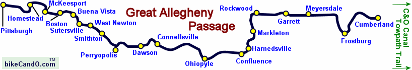
The Great Allegheny Passage (GAP) is a multi-use, recreational, repurposed railroad line (rail-trail) that stretches ~150 miles from Cumberland, Maryland to Pittsburgh, Pennsylvania. We decided to start at the Pittsburgh end and work our way east to Cumberland with the thought that we’d continue onto the C&O Towpath from Cumberland to Washington DC if we were enjoying ourselves. We used the free GAP trail guide provided by midatlanticbiketrails.com and it was excellent. We referred to it daily.

Instead of trying to fight traffic and find parking for Blanche in downtown Pittsburgh, we opted to start in Homestead, PA, and yo-yo (ride in both directions up and back) to give us a bit of time to acclimate to our new bikes. We’d never really ridden them for any distances up to this point. As our nephew, Erik, points out… that way you get to see the signs from both sides.
We’d been camping since Canada and thought a hotel night would be a nice change. We booked into a Holiday Inn Express which was located right across the street from a trailhead. We did a bit of reconnaissance and checked out the historical Rivers of Steel pump house. According to the information sign “The Pump House and its adjacent water tower supplied and stored millions of gallons of water each day from the Monongahela River for the Carnegie Steel Company’s vast steel-making operation in Homestead.”
We sussed out the entrance to the trail and planned the route. We were primed and ready to start our adventure.

Day 1 -Homestead to Pittsburgh - 19.5 miles RT
The next morning dawned bright and sunny, a perfect day for our first day on the GAP. Since we hadn’t ridden in a while, we decided to start out easy. We rode about 10 miles into the Burgh, as the locals call Pittsburgh. Purple cone flowers and wild bergamot lined the beginning of the path but vanished as we neared the city.


This section of the GAP is called the Three Rivers Heritage Trail, an urban rail-trail, so-named because it ends at the confluence of the Ohio, Allegheny and Monongahela Rivers. The trail is mostly paved, heavily used and well maintained. It’s fairly level with a few hills up and over a few of Pittsburgh 446 bridges. Easy enough for a first day.
We relaxed for a bit at beautiful Point State Park, the western terminus of the GAP and enjoyed the local color and cityscape.


A large bronze plaque is embedded in the walkway marking the meeting of the three rivers, Pittsburgh’s “Golden Triangle”.

Inside the plaque, a small medallion designates this spot as the western terminus of the Great Allegheny Passage.

According to the Visit Pittsburgh website The Duquesne Incline (/do-kane ) is a funicular railway that scales Pittsburgh’s Mt. Washington. Designed by Hungarian-American engineer Samuel Diescher, the incline was completed in 1877 and was originally used to transport people and cargo up the steep slopes. Now it costs $2.75 for a one way trip to a scenic overlook.

We watched barges moving slowly along the river, maneuvering under the many bridges.

We passed the Hay’s Bald Eagle Nest Viewpoint. We didn’t see any eagles, but there were quite a few folks with binoculars crowding the trail.

The 10-mile return trip to Homestead (20 miles RT for the day) took longer than the trip in. We tended to lollygag a bit more and made more stops for photos. The end of the first successful day on the GAP merited a cold draft beer and a late lunch. We dropped off the bikes at the hotel, cleaned up a bit, and walked to Homestead’s Waterfront district. We wandered around the shops and restaurants and finally settled on the Rock Bottom Brewery. We ate outside, savored the cold brew, and watched the passersby. One thing we learned about the Rock Bottom: each pub has its own brewmaster and its own unique beers. Always something new.
Day 2 - Homestead to Boston - 22 miles RT
We were slow to get started, but once we were on the trail, we made good time, averaging 12-15 mph. When the trail passed through the busy areas of town, it was a bit slower… especially when we had to wait for trains to pass.

We rode along historic Braddock Road, a military road built in 1755 by the British. It was considered the first improved road to cross the barriers posed by the Appalachian Mountains. Built by men under the command of General Edward Braddock, it was part of an expedition to conquer the Ohio Country from the French at the beginning of the French and Indian War. A young officer, George Washington, was Braddock’s aide-de-camp. We love the history. It’s always a bit of thrill to know who has passed this way before.

We passed on the edge of Dead Man’s Hollow. Now a 450 acre conservation area, it was considered a hangout for outlaws as well as a haunted place. As the story goes, Dead Man's Hollow earned its name in 1874 when a group of adolescent boys were roaming through the hollow and came upon a decomposed body that was hanging by a noose. The victim was never identified and no one was ever charged for the murder. Legends and stories grew about the incident.
Unfortunately, bicycles are forbidden from the area, so we cycled on.

Photo credit: Bill Trautman. When we arrived at this spot, the info sign had been obliterated by graffiti and weather and not legible. Bah!
We had followed the route of the Monongahela River out of Pittsburgh, but now we followed the Youghiogheny River, locally known as the Yough (Yawk). Sometimes we rode on the road, but mostly it was on a tree-lined, shady trail through tunnels, over trestle and bridges. Our butts aren’t quite used to the ‘saddle time’ yet and we notice that we both walk a bit funny when we first dismount.
When our ride was complete, we loaded up the bikes and drove to Connellsville. We’re putting all those accumulated hotel points to good use now. The Comfort Inn in Connellsville is right on the trail. The staff is friendly and helpful, the hotel is lovely and it is perfectly positioned for continuing our yo-yo rides.
Day 3 - Sutersville to Boston - 23 miles RT
We drove to the Sutersville trailhead where I took my first tumble. We weren’t even on the trail yet when I foolishly crossed railroad tracks at a bad angle and down I went in the middle of the road. The bike was fine. I banged up my left knee, bruised my right shin, scraped my chin, and severely wounded my ego. David came to my rescue, righted me and the bike and moved us out of the road. It knocked the wind out of me, but after a few minutes, I got back in the saddle and we continued on the trail. I vowed to be more careful crossing railroad tracks in the future.
We saw all sorts of animals on the trail today. One big black rat snake crossed just in front of us… 2-3’ long maybe. Chipmunks, squirrels, rabbits, birds, especially cardinals, and several big fat woodchucks. All scampered or slithered out of the way long before I could stop for a photo.

The Youghiogheny River Trail (YRT) is probably one of the best bike trails we’ve ever ridden. It’s even, smooth, wide, and surfaced in crushed limestone. Another rider called it a super highway compared to most other bike trails he had ridden. It’s all maintained by volunteers and they do an excellent job. Signage along the trail is awesome. There are benches and picnic tables and rest stops along the trail and at each little town.


The Dravo Methodist Church was built on this site in 1824 and destroyed by fire in 1924. The last burial was in 1942 and the cemetery is currently maintained by a local historical society. We like wandering around in old cemeteries and looking at the old gravestones. They tell stories of the people who once lived and worked here and are now remembered mostly by those who stop by to visit out of curiosity.


There were several small waterfalls along the trail. The most impressive was simply called the Red Waterfall, for obvious reasons. According to the nearby signage, ‘The water here is acidic and iron-rich coming up to the surface from underground mines, staining the rocks rust-red.’ Acid mine drainage is a major cause of water pollution. The Ocean Coal Company’s Ocean #2 mine established in 1900 is purported to be the chief cause of the Red Waterfall.

When we returned to the hotel, I elevated my leg, applied ice packs to my knee and took some Ibuprofen. My legs are a bit black and blue and my knee and chin look a little nasty, but that too shall pass.
Day 4 - Whitsett to Sutersville - 28 miles RT
We were hopeful I’d be able to ride today, but prepared to take a day off. The ice packs and Ibuprofen must have helped because riding was not a problem. Walking was a bit dodgy and stairs were especially painful, but bike riding didn’t seem to bother me much at all, so we were off bright and early on yet another sunny, beautiful day. We drove to the Whitsett Trailhead to start our day.
Whitsett was an especially bike-friendly little neighborhood with free iced bottles of water sitting in coolers, picnic tables, porta-potties (clean ones!), and snacks on offer.


We enjoyed the well wishes of neighbors along the trail as well as their humor.


West Newton was a large rest stop and trail head and quite busy. There were restaurants, a welcome center with brochures and souvenirs, water fills and cycle tools in case they were needed. We picked up a brochure that outlined artwork along the trail and we noted a piece immediately. Affectionately known as either Rusty or Spike, the life-size Pioneer Point Sculpture by Bill Secunda is made of railroad spikes welded together and represents the early pioneer history of West Newton.

Just outside of West Newton is the Gap Rail Campground which looked to be busy. Perhaps, twenty years ago cycling all day then camping out at night with a bunch of strangers would have been a fine adventure and we certainly camped out on the Cowboy Trail last year when no hotels were available, but the prospect of a hot shower, an air-conditioned room, and a comfy bed always trumps sleeping on the ground.

When we reached Sutersville, I took a look at those railroad tracks that had messed me up and offered a few choice words which elicited no reaction at all from the tracks, but made me feel better. We turned around and headed back to Whitsett from whence we had come. A cold beer, a hot shower, an air-conditioned room, a comfy bed… ahhh… the good life!
Next time, we conclude the 150-mile Great Allegheny Passage… then figure out what’s next.