

Blue Highways - US Highway 70
/When William Least Heat-Moon Heat wrote ‘Blue Highways: A Journey into America’ in 1979, he coined the term ‘blue highways’ because secondary highways on the old paper road maps were always printed in the blue. On the return from our holiday East Coast trip, our oldest son, Brennan, suggested driving a ‘blue highway’ and since we relish road trips. but definitely dislike traveling on major interstates unless necessary, we opted to take his suggestion.

US-70 no longer continues to California, but it once did.
A couple of years ago, we drove US-2, the northernmost cross-country route in the USA aka ‘the high road’, from Washington state to Maine and really enjoyed it. This time we chose US-70 (not to be confused with I-70) which crosses the country from Atlantic, North Carolina to Globe, Arizona. It was established as one of the original highways in the interstate route system developed in 1926. The route has changed over the years sharing the roadway with other numbered routes and even some interstates like I-10, I-40, but for the most part, it maintains its integrity and spans a total of 2,381 miles.

US-70 begins in Atlantic, NC and ends 2,381 miles later in Globe, AZ.
Brennan also turned us on to US Highway Endpoints website which provides a history of US-70 as well as the towns through which it travels and, in some cases, sights to see. In addition to Endpoints, we also used Atlas Obscura and Roadside America, so as not to miss anything ‘unique’ along our route.
You cannot be in a hurry when you’re traveling a ‘blue highway’. They meander their way through small towns and large cities, through urban neighborhoods and countryside and never seem to travel in a direct line, jogging this way and that. When they were first developed, US highways connected existing roads and trails that usually followed the terrain. If you have the time and the patience, it’s a fun way to travel and see the country. Despite the meandering, we were confident we’d eventually end up out west at some point.
We began our travels by heading east to the Atlantic Ocean and the town of… you guessed it… Atlantic, North Carolina. Signs warned of the impending ‘end’ of US-70, but the actual ending was rather abrupt… a marina stood in our path. We could see a road on the other side, but the road ended here. This was the eastern terminus US-70. We turned around and began our drive west.


US-70 rarely avoids a town or city in its path because that’s what blue highways do… they don’t bypass, they drive right through. We drove through downtown Raleigh, the state capital, and continued heading west… sort of.

Raleigh, North Carolina’s Capital City
Every city and town has at least one something of which to be proud. Murals, signs, monuments, statues, parks and sometimes oddities dot the streetside along America’s highways. Atlas Obscura made sure we didn’t miss much of importance along the path. Sometimes we opted to give certain sights a pass, but when it came to the ‘world’s largest’ anything, we couldn’t resist. For instance…
Constructed in 1998 for Furnitureland South in Jamestown, NC, the World's Largest Highboy Chest stands 85’ (30 m) tall and 40’ (13.7 m) wide. Though it appears to be wood, it’s actually made of synthetic stucco over a steel frame.

That’s one high Highboy!
Not far away, the World's Largest Chest of Drawers stands 36’ (11 m) high and according to Atlas Obscura was built in 1926 to call attention to High Point, NC, known as the Furniture Capital of the World.

Mismatched socks… just like mine
A large-scale replica of a Duncan Phyfe armchair is a landmark of Thomasville, NC. Built in 1950 by Thomasville Furniture Industries, it is, in fact, the world’s largest Duncan Phyfe chair.

In Old Fort, there’s “a 30-foot-tall (9 m) arrowhead hand-chiseled in granite. The landmark was unveiled to a crowd of more than 6,000 people on July 27, 1930, by Marie Nesbitt as a symbol of the peace achieved in an earlier century between pioneers and Native Americans.”

Must have been a very big Bow and arrow!
The day was gray and overcast and cold… a brrr-y 22F (-6C) when we left our hotel. We had traveled the breadth of North Carolina from the ocean and now passed over the Blue Ridge Mountains through the Pisgah National Forest on narrow, winding roads. Over the ancient Appalachian range and finally entering Tennessee, US-70 either shared I-40 or paralleled the interstate for miles. We stayed on course through Knoxville and then drove right down Broadway in Nashville taking in the frenetic hubbub of the Music City as we passed.

In addition to a very large catfish and a somewhat worn wall mural welcoming us to Dickson, we sought out the ‘Broadway of America’ mural, aka US-70.


We didn’t notice until later that’s the mural is a mirror image of an actual map. Dickson is actually west of Nashville not east and Knoxville is east. Hmm… big faux pas or intended?
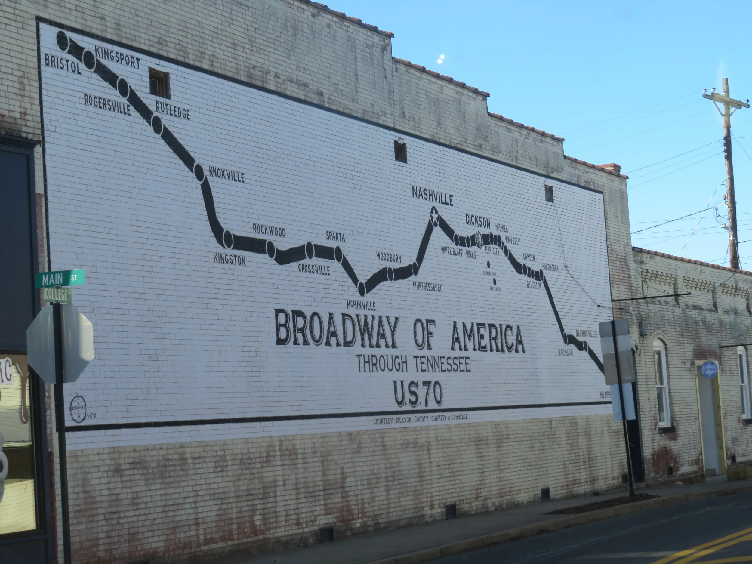
This map is a mirror image of a roadmap.
In Waverly, we stopped to admire the Walls Art Park, a free park set aside in a wooded hillside venue expressly intended for mural and graffiti artists to display their talents. The park rules are prominently displayed and it’s an interesting concept. We thoroughly enjoyed our brisk walk along the paths in the woods to stretch our legs while admiring the interesting artwork. Graffiti that’s not only legal, but encouraged… what a concept! Enlarge them with a click on the image.


In Memphis, we drove along B.B. King Boulevard and sang the blues on the ‘blue highway’, not because we were inspired but because US-70 seemed to end at the Mississippi River and it was nearly impossible to cross. The bridge was closed. Entrances and exits on the highway to access alternate bridges were closed. For an hour, we tried to find our way out of the city and across the river. It was a Twilight Zone kind of morning. We were doomed to stay in Memphis. Finally, a breakthrough and we found our way across the Mississippi (no swimming or rafting required) and picked up US-70 on the other side in West Memphis, Arkansas.
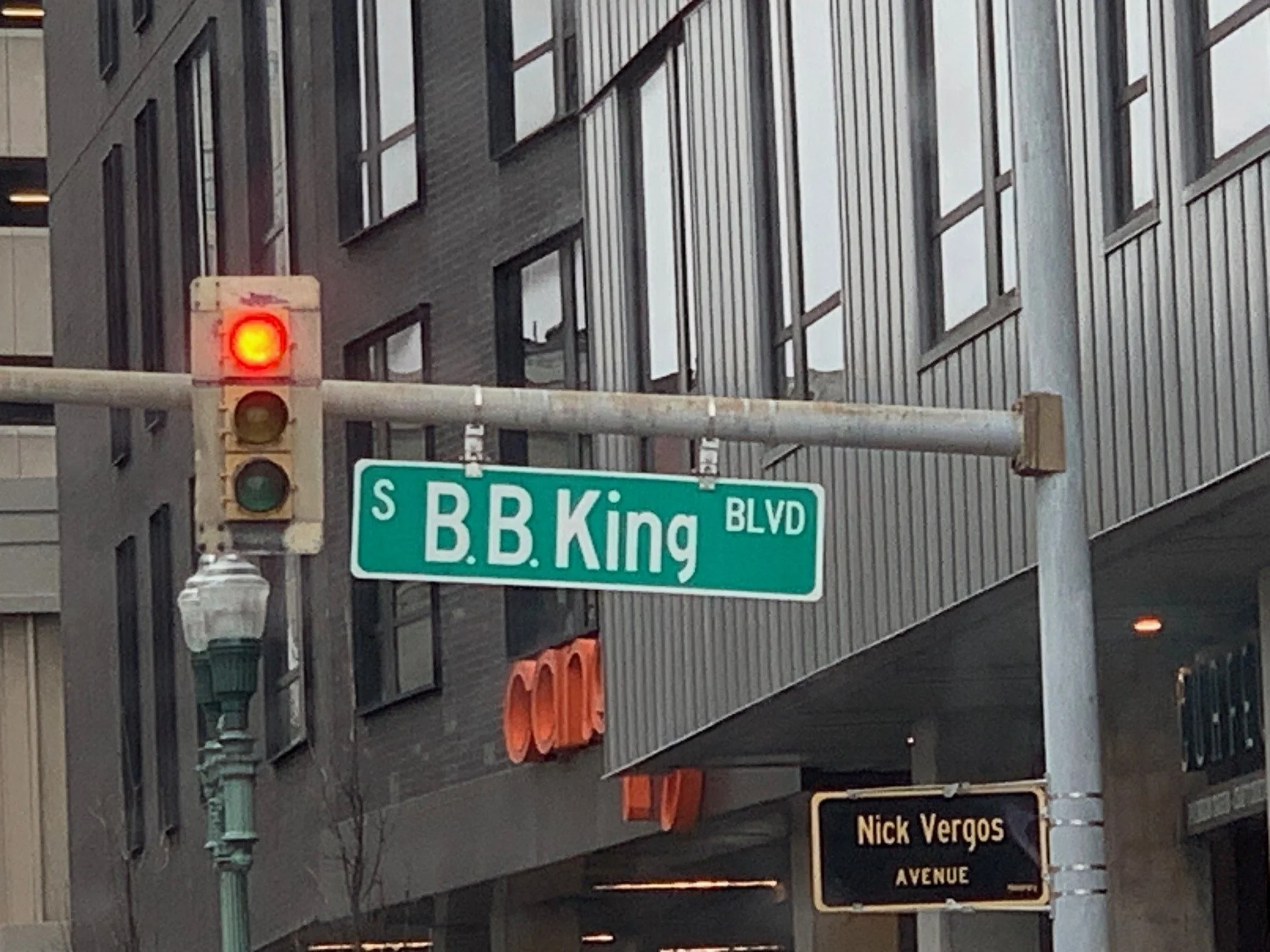
Out of Memphis at last!
Join us next time as we complete our route with a visit to Hot Springs National Park, a stop in Earth, Texas cottonfields and giant tumbleweeds, aliens in Roswell and finally the western terminus of US-70 in Globe, Arizona.