The Iconic Busselton Jetty

We made the grueling 11 nm passage from Quindalup to Busselton without incident, bruises or any broken equipment (that we know of). It was easy to tell when we arrived. Busselton has the longest timber-piled (wooden) jetty in the southern hemisphere, extending over a mile out into Geographe Bay. We were just over a mile from shore and would have run right into it if we hadn't dropped the anchor when we did.

quindalup to busselton

We headed into town around Noon and beached the dink on the foreshore sand. This anchorage is close to everything in town which is quite convenient. We headed first to the Visitor Info Center to get a town map. I was momentarily distracted when we heard quite a ruckus emanating from a huge, spreading gum tree which turned out to be the squawking of a large number of little corellas.

little corellas

The Visitor's Center is housed in a lighthouse tower right at the entrance to the jetty. We got our map and paid $2/ea to climb the stairs of the tower to the observation deck at the top for great views of the jetty stretching out a mile into the Bay.

view

As is the Aussie way of shortening up words and city names, Busselton is called Busso. It always takes us awhile to catch on.

busso lookout

The jetty is definitely the highlight of Busselton, a city icon. Construction on the jetty began in 1853 and was originally designed for loading timber. Because the bay waters are so shallow, the jetty was continually extended until the 1960s when it reached its current length of 1841m/5990'. It also featured a rail line along its length that originally operated as part of the railway line into Busselton from nearby Bunbury. The track is still used to transport tourists from one end of the jetty to the other.

jetty train

The last commercial ship visited the jetty in 1971 and it was finally closed to shipping in 1972. Once government maintenance of the jetty ceased, it predictably began to deteriorate. Wood borers, rot, several fires, Cycle Alby in 1978 and a major fire in 1999, took their toll. A not-for-profit organization raised public awareness and the funds to save the jetty. With local and national government participation, the jetty was restored. Walking on the jetty costs $2.50 for a day pass, but it seemed well worth the price since all the funds collected go into its maintenance and repair. Parts of the old jetty pilings remain beside the new jetty, a contrast between old and new.

jetty tix

It's still school holidays and the jetty was packed with people. Some fished. Some meandered along gazing and chatting. Some pushed baby strollers. Some parents worked at keeping their kids in check. Others blissfully ignored their kids altogether. When the train chugged by, it was hard work finding a place to walk.

fishing on the jetty

Near the end of the jetty is an underwater observatory that descends by spiral staircase 8m/30' below the jetty to observe marine life. The small aquarium only accommodates 40 people at a time and the line was long. Reviews on Trip Advisor for the jetty were great, but for the aquarium only mediocre. At $29.50/pp, we thought it was a bit pricey and gave it a pass.

Despite the number of people, we enjoyed the long walk. There was a section with plaques in memory of local people who had died and been involved in some way with the jetty or considered the jetty a favorite place. There were interesting informational signs and several unique weather vanes along the way.

jetty collage

Best of all, of course, was the view looking back towards shore.

view to shore

Walking to Dunsborough

We arrived in Quindalup, anchored and didn't move off the boat for a day. It's easy to just enjoy hanging out, writing, reading and being our usual lazy selves. The cruising life can be truly grand some days. We did manage to launch the dinghy eventually. We decided to walk into the closest town of Dunsborough, more to assuage our guilt about being boat slugs, than because we needed anything in town. The walk to Dunsborough, in my estimation, was better than the town itself. Oh, don't get me wrong, Dunsborough's a nice little town, but getting there was stellar.

trail

Geographe Bay Road follows the coast from where we beached our dinghy on the Quindalup shore to Dunsborough, ~4.5km/3mi to the east. Between the road and the beach is a paved trail about 30m/100' from the road itself, that meanders through bush and groves of eucalypts and provides easy access to the beaches on Geographe Bay. White ibis and magpies pecked at the lawns and red wattle-birds made their presence known in the trees.

ibis

The path is heavily used by cyclists, walkers, joggers, dog walkers and kids on scooters and skates. There are stops along the route with apparatus for exercise enthusiasts. There are picnic groves with public barbeques. We counted several playgrounds with interesting, colorful equipment for the kids. Benches are placed strategically for sitting, resting and watching the world go by. There was a bike hire place as we arrived closer to town, public restrooms and even a place which dispensed free filtered water to fill up your water bottle. We found this to be pretty remarkable for a small town that obviously takes walking seriously.

bike hire

We were so involved in the walk and our conversation, we missed the very conspicuous turn-off to the town center and walked past it another 1km before realizing our error. We backtracked and headed the two blocks into town. It's spring holiday here for the kids and Dunsborough was crowded with people and traffic and it seemed overly frenetic. We checked out the Visitor's Center, bought a couple of freshies at the local IGA supermarket and then headed back to the walking path.

Walking back we checked out some of the beach access paths.

beach access

Some led directly to the beach, others to lagoons and tidal ponds teeming with ducks, gulls and very long-legged, aptly named black-winged stilts.

black winged stilt

We could see Cups, far away in the distance, bobbing gently in the bay waters.

view of cups

It took close to an hour to get back to the beach where the dinghy waited for us. A willy wag-tail danced on the bow of our dinghy, darting away as soon as we approached.

willy wagtail

Some days are not particularly eventful. Some days are just meant to be appreciated because you're around to enjoy them.

Hamelin Bay to Quindalup

After a relatively peaceful night anchored in Hamelin Bay (read that ... the anchor alarm only sounded once at 0130 when the tide changed and there was no wind), we woke at first light to another cold morning.  

first light


To our surprise, there was a buzz ashore and fishermen (tens of them) were lined along the beach enthusiastically fishing for ... what? Salmon maybe? A row boat had strung a net between two utes (pick-up trucks) on either end of the beach, obviously hoping for a big haul. It appears that it's the right time of year here for salmon and the fishermen in Albany had been in a frenzy about it.


fishermen


We'd seen a pair of dolphins playing near the boat last night and this morning as David unsnubbed the anchor chain, a huge manta ray glided by. Its pectoral fins moving like wings propelled it effortlessly and it swam, ever so gracefully, under, around and behind the boat. We watched ... mesmerized … as its dark silhouette moved just under the water's surface. Too dark, no pics … sorry.

With light W/SW winds forecast, we were not surprised in the least to be sailing with NE 15-20 winds up the coast. We've given up on the weather forecasts and we take what we get. By mid-morning the wind disappeared and we motor-sailed for awhile under thick, heavy gray skies. There was a fringe of pale blue sky hugging the land, but the overcast skies above us, kept it chilly and raw. Rain clouds danced around us, but like yesterday, nary a drop fell on Cups.


heavy grey skies


We finished up our passage soup for lunch and the sun finally appeared, burning off the cloud cover and warming us up. Off came the jackets and heavy fleeces. Cape Naturaliste came into view and we snapped more photos than you can imagine. It's not a fleeting sight, but rather as we rounded the cape, it provided different views for hours and I just kept snapping. Better clouds in the background here … more blue sky from this vantage point … better sun there.


cape naturaliste


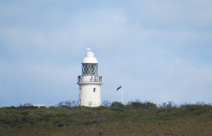
As we got closer to the lighthouse, we could see people on shore climbing the stairs on the path to the lighthouse and people on the walkway at the top of the lighthouse. I'm already planning our time ashore.


people on lighthouse


It was the French explorer, cartographer and naturalist, Nicolas Baudin, who led a French expedition to Australia in 1801 … just about the time Matthew Flinders was coming from the east. His two ships, the Geographe and the Naturaliste (captained by Jacques Hamelin … weren't we anchored in Hamelin Bay next to Hamelin Island just last night?) were the first to explore and map the western coast of the continent. He named Cape Naturaliste and Geographe Bay after his ships. According to Wiki, by the way, his scientific expedition was a great success, with more than 2500 new species discovered.

We turned the corner and sailed into calm, peaceful Geographe Bay, mindful of what seemed like hundreds of small fishing boats darting about like flies. The bay is huge and expansive, protected from the Indian Ocean swell and predominant winds. In the distance to the south, we saw a flotilla of masts, and headed for the small town of Quindalup. The bay shallows very gradually and we dropped the anchor in a sand patch in 3.5m/ 12', tidied up and settled in for a peaceful night.


masts at quindalup


We're feeling less rushed now that we've crossed the Bight and rounded Cape Leeuwin. Everyone we've met has said that this is the best time of year on the West Coast. We have lots to do before departing to cross the Indian Ocean in July, but we plan to enjoy our time here AND get maintenance and repairs completed.