The Blue View - St. Helena Driving Tips

The scenery on St. Helena Island is fabulous, with mountain and sea vistas everywhere. We wanted to explore as much of it as we could, so we hired a car for a few days.The total area of St. Helena is about 47 square miles. I don't know how many actual miles of road there are, but I do know we drove most of them. The driving here is somewhat different than in other places, and I thought I'd share a few driving tips I discovered. views of st. helena island

Drive on the left.

This is a British territory, so you drive on the left here. If you aren't used to driving on the left, it's easy to forget and find yourself in the wrong lane. Even harder is remembering which lever is the turn signal and which is for the wiper blades. These are reversed in a right hand drive vehicle. You can always tell when an American is driving, because we signal our turns with the windshield wipers.

The car.

Don't expect that sparkling new car that you might rent from Avis or Hertz. Our car was a rather battered, sixteen year old Toyota. When we did our initial inspection, rather than making note of any scratches and dings, we noted the areas that weren't dented. The clutch engaged about an inch off the floor and it took about three tries to get it into reverse. The “check engine” light was on, and the ignition switch apparently gave it up some time ago. The door locks weren't a problem as no one locks their car here anyway. To start the car, the ignition was switched on with a toggle switch, then a pushbutton switch was pressed to engage the starter. The modified system worked just fine, and eliminated the need for such superfluous things as keys. Despite its age and condition, it ran just fine and we had no problems with it.

a rental on st. helena

The emergency brake.

The most important item on the car – make sure it works. I used it not only for keeping the car where I left it when it was parked on a steep incline, but as an aid when starting up after stopping on a hill.

The horn.

The horn is the second most important item on the car. It is used frequently when approaching one of the hundreds of blind, hairpin curves on the narrow roadways to warn drivers coming from the other direction.
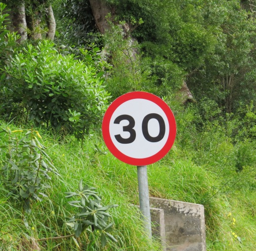
Speed.

Distances are in miles and speeds are in miles-per-hour – the only place outside the U.S. we've been that doesn't use metric units. The maximum speed limit on the island is 30 MPH. I thought of it as more of a goal than a limit – in four days of driving, I don't think I found a stretch of road I could go that fast.

speed goal

Right-of-way.

When two cars approach each other, the car going uphill has the right-of-way. If the road is too narrow for the cars to pass, the car going downhill has to back up until the road is wide enough. We had to back up a good quarter of a mile when we encountered a car as we were leaving the High Knoll Fort after our visit there.

Standard Transmission.

As is the case in most places outside the U.S., the rental cars are all standard transmission. On St. Helena, it is only necessary to have a two speed transmission, however. I never had occasion to drive fast enough to use 3rd, 4th or 5th gears.

Waving.

Every driver and pedestrian we encountered waved to us. We got into the habit of waving back, although it was difficult at times when I was busy downshifting from 2nd to 1st while blowing the horn and shutting off the wipers after signaling a turn.

Obstacles on the roadway.

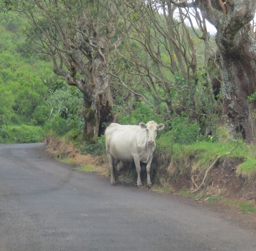
In Tasmania, we were constantly on the lookout for marsupials in the roadway – wallabies, wombats, Tasmania devils, etc. In South Africa, we were watchful for boks – springboks, rheboks, gemsbok and kudus. Here it was the occasional goat leaping out or the odd cow lying in the road. And the island is a laid back, slow paced kind of place. It is not unusual for someone to stop their car in the road and have a nice chat with a friend walking along. We encountered a car parked in the middle of the road with four or five people standing next to it. I stopped and asked whether they were having problems. “Nope – just having a yarn” was the reply. We soon learned that no one had a problem when we stopped in the road to take a photo or admire a view.

cow in the road at st. helena island

The roads.

While the roads are narrow and steep with switchbacks and blind curves everywhere, they are in quite good shape. Most are paved and have very few pot holes, and with few exceptions, the gravel roads we traveled were smooth and well graded.

hairpin turn on st. helena island

Fuel.

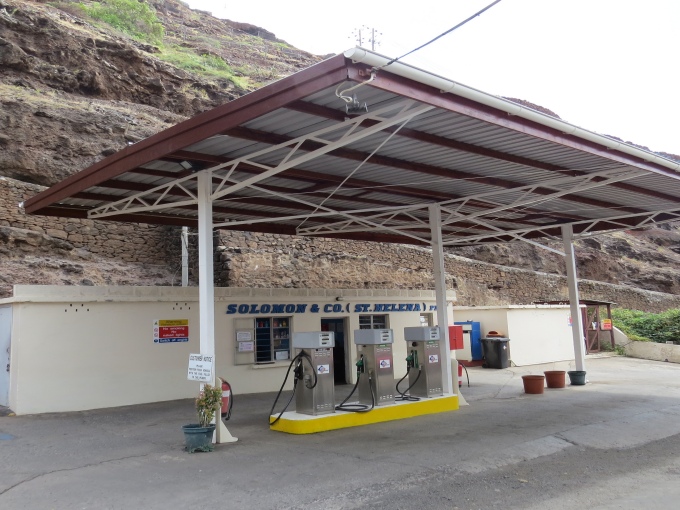
Fueling up requires some planning. There are only four gas stations on the island, and their hours are limited. No fuel is available on Sundays, and they are all cash only.

solomons gas station st. helena island

Maps.

The local tourist road maps are confusing. They don't show all the roads, aren't quite to scale, and since many roads don't have signs, we were often not quite sure as to where we were or which fork to take. I suppose some people would refer to this as being lost, but I think that is far too strong a term. Anyway, Marcie had had the foresight to download the St. Helena maps for our iPad app “Maps with Me”, which was amazingly accurate and detailed. After our first day of driving using the local paper road map, we relied on the electronic map and had no problems.

Overall, we had a great time driving the island. Other than a few stressful moments getting used to the driving etiquette here, we had no problems. The car ran fine and the other drivers were forgiving of my mistakes. And by Day 4, not only was I getting into the car on the correct side, I was better than 50-50 when signaling a turn.

The Blue View - Pilot Charts

Want to know where the current along the west coast of South America is the strongest?  How about the prevailing winds off St. Helena in April? As we were planning our Atlantic crossing, one of the references we used was the set of pilot charts for the North and South Atlantic. The NGA (National Geospatial-Intelligence Agency) Pilot Charts depict, graphically, weather conditions, sea states, prevailing winds and currents and a host of other information for different times of the year for all the oceans of the world. pilot atlas

We owe their existence to a U.S. Navy officer, Matthew F. Maury, who was an expert in marine meteorology, astronomy, and bathymetry. He developed the first wind and current charts in 1847 by analyzing and compiling data from thousands of ships' logs. From these charts, most of the current sea routes were established, as well as which areas of the oceans should be avoided at different times of the year. His invaluable contributions to meteorology and oceanography gained him international recognition, and he was variously referred to as the “Pathfinder of the Seas”, the “Father of Oceanography” and the “Father of Modern Naval Meteorology”. Quite the guy!

maury

The descendents of Maury's wind and current charts are the NGA Pilot Charts, and there are now five sets – one for each of the oceans. Each set has a separate chart for every month of the year. The charts are divided into 5 degree rectangles, and within each rectangle, it is easy to determine the prevailing wind speed and direction, and the likelihood of gales, storms and calms. Each chart also shows the ocean currents, both direction and strength, average sea and air temperatures, ice limits, barometric pressures, wave heights and visibility. A lot of information is packed into each chart, and every time I use them, I discover something new.

chart

There are a few caveats to their use, however. First, they are not, of course, weather forecasts – only historical averages of weather in a given area. It is little consolation to know there was only a 5% chance of encountering a gale when we are sitting in the middle of one.

The second caveat is a consequence of their very usefulness. For example, if mariners know a particular area is especially prone to hurricanes during the month of September, most vessels, especially any that cannot outrun a hurricane, will avoid that area at that time. Since the data regarding hurricanes is based on actual logs of vessels, and if very few vessels choose to sail through a hurricane, then the frequency and strength of these tropical storms will be underestimated.

The third caveat is that they are based on data collected over decades in the late 1800's and early 1900's. In my research, it's not clear whether data is still being collected and updated. If the earth is truly experiencing global weather changes, the data will become more inaccurate as time passes.

A final caveat is that many parts of the earth are affected by global cycles like the El Niño/La Niña years. Thus, a particular 5 degree rectangle of a pilot chart that indicates a 20% likelihood of a southerly wind may, in reality, be a 95% likelihood in an El Niño year and a 5% likelihood in other years.

Given all these caveats, we find that pilot charts are still very helpful, and they are one tool we use when planning long passages. We also check global weather forecasts to see whether the current year is an El  Niño or La Niña year and what effect that will have on local weather. In addition, we research the predictions for tropical storms … will this be a good year or a bad one?

With all this planning, the conditions we encounter are still a crap shoot and depend on our luck as much as anything. Had we left Cape Town heading for Norfolk in the beginning of April as we had planned, we probably would have run into Tropical Storm Ana – the second earliest tropical storm to ever hit the east coast of the U.S.

Thus, the most important part of every passage may well be the hearty tot of rum we give Neptune on our departure.

The Blue View - Baby Needs a New Bailer

the new bailer Our old dinghy bailer is just about shot. The sun's UV rays have made it brittle and it's starting to crack. No matter – Marcie just finished a jug of laundry detergent, and it is the perfect size and shape for a new bailer. Being the parsimonious sailors that we are, we make use of everything we can.

When there is a lot of water in the dinghy, most anything will work as a bailer. That's not to say that a good bailer wouldn't be preferable, but I've used hats, oars, and even cupped hands quite effectively when there wasn't a real bailer available (although there were times when I wished I had webbed fingers). To move a lot of water quickly, it is more the technique than the tools at hand.

bailing with homemade bailer

When a good bailer is worth its keep is when the water gets down to the last few inches. Then I want a flat bottomed scoop. We've certainly purchased those classy bailers sold at the chandleries in the past, but I don't find that they do any better job of bailing than my homemade jobs. They do last about twice as long in the sun, but twice nothing, which is what mine cost, is a lot less than the cost to buy a bailer.

I find a 2L size laundry detergent jug is perfect … it is flat on the sides, has a handle, and is big enough to bail large quantities of water quickly, but small enough to dip out the last of the water from the small well near the transom of our dinghy. Usually, Marcie finishes up the laundry detergent in the current jug just about the time the old bailer has about had it. Any similarly shaped heavy plastic container with a screw-on lid will work, however -  bleach bottles, milk jugs, etc.  In a pinch, a gallon (4L) size jug will work, but is a bit too large and flimsy for my liking.

marking the bailer

beginning cut

cutting the bailer

When I'm done bailing, I stuff the bailing sponge into it. This weighs it down enough to keep it from blowing away.

The first few times I made a bailer, I simply dug out my box cutter and hacked away. The bailers worked just fine, but were sometimes rather oddly shaped. Now I mark the jug where I intend to cut it. BTW, it took me approximately ten times longer to write the blog about making a bailer than it did to actually make it.