Rounding Cape Leeuwin

leewin just in sight

Rounding a cape is always a big event for us. Sometimes it's a benign experience and sometimes we find ourselves wondering why it is that we choose to sail around major capes. There are five Great Southern Capes and Cape Leeuwin will be our fourth. (Marcie counts it as our last one – but even though we have sailed to within 30 miles of the fifth, the Cape of Good Hope in South Africa, and actually stood on it, I don't think we can count it until we actually do round it aboard Nine of Cups. On this, we agree to disagree – but I'm the one writing this blog, so for now we'll go by my count... David) In any event, adding Cape Leeuwin to our “rounded cape” list is one tick off the bucket list.

The sailors of old feared the great capes, and for good reason. Their latitudes and topography, sudden and dramatic weather changes, strong currents, off-lying hazards and potential rogue waves all contributed to give the great capes the reputation of being some of the most dangerous places in the world to sail.

Today, with modern navigational equipment, better charts and weather forecasting, and engines to get us out of ticklish situations, rounding the great capes is far less dangerous than it was for the old sailing ships. They had no choice but to take whatever weather presented itself, and it sometimes took weeks to make their way around. We can wait in a secure anchorage until we get a good weather window, then make a quick passage around the cape and find another anchorage before the next weather system arrives. That isn't to say we take any cape for granted or don't respect how quickly things can change. Very rarely does everything go as planned – when we rounded Cape Horn, for example, the 15 knots of wind that were forecast quickly deteriorated, and it was blowing 50 knots by the time we found shelter in Caleta Martial. We did have good charts, however, and so, unlike the old sailors, we were able to find shelter.


leeuwin chart


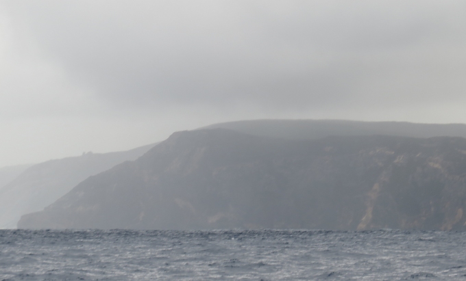
Cape Leeuwin is the most southwesterly point on the mainland of the Australian continent. It was named by Matthew Flinders in honor of the first known ship to have visited the area. The Leeuwin ("Lioness"), a Dutch vessel, had charted some of the nearby coastline in 1622. Cape Leeuwin has a large number of reefs, rocks and tiny islands, some extending more than 5 miles offshore, making it particularly hazardous. At least 23 ships have come to grief here.


leeuwin light house


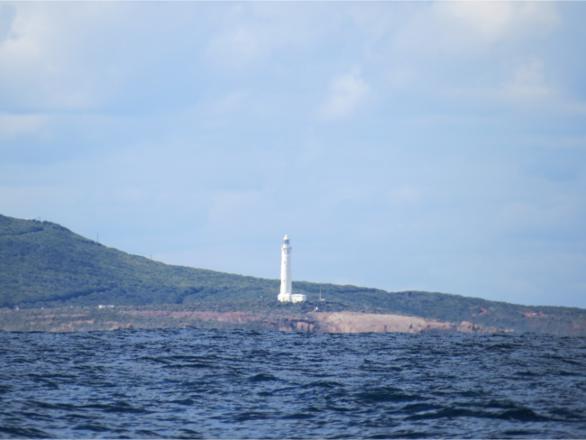
To assist mariners in these treacherous waters, the Cape Leeuwin lighthouse was built. It was completed in 1896 and is the tallest lighthouse in Western Australia. The tower and cottages were constructed of local limestone and the lighthouse is quite stunning, even from our vantage point 4 miles offshore. It was one of the last lighthouses in the world to remain totally manually operated. Until 1982, the lighthouse keeper had to light the kerosene lamp and mind the clockwork mechanism each night. In 1982, it was converted to electricity and was fully automated in 1992.

If you are Australian, Cape Leeuwin is considered the point where the Indian Ocean and the Southern Ocean meet. (Most other nations consider the Southern Ocean to only exist south of 60ºS – and by this definition, Cape Leeuwin is where the Pacific and Indian Oceans meet). By either definition, however, we are now in the Indian Ocean – a new ocean for us!


leeuwin route


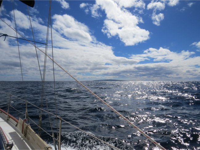
The forecast winds never materialized. We had wind on the nose until we were almost to Cape Leeuwin, when it backed to the SW and began to die just as the sun came out. Thus, we rounded the fearsome Cape Leeuwin in near calm conditions on a pleasant sunny afternoon.

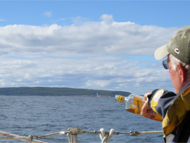
As we passed the cape and entered the Indian Ocean, we gave a tot of rum to Neptune, thanking him for looking after Nine of Cups and her crew on our many passages and asking for his continued protection in our future passages. We also saluted the many sailors who, due to misfortune, perished in these waters.


tot to neptune


We turned the corner and started heading north late in the day. Since we couldn't make it to Quandalup in the daylight and conditions were so benign, we anchored in picturesque Hamelin Bay for the night.

That's our account of rounding Cape Leeuwin. Of the 4.5 Great Southern Capes we have now rounded, this was by far the most benign. It doesn't make for an exciting story, but we are certainly not complaining. (Well, okay, except for that little bit of whinging about not having the predicted winds).

Leaving Albany

Sailing the Rainbow Coast

It seems we haven't been in Albany very long at all, but of course, we have … nine days, in fact. Weather and seasons, however, do not wait for sailors and it's time to get a move-on. The final provisioning is done. Laundry is all caught up (as if). Fuel and propane are all topped off and we returned the car to Don and Judith and said our goodbyes. We're all ready to go. I used the rest of the fish Tom gave us for a passage chowder. We're off! Well not quite … the weather forecast changed overnight from S/SE to SW winds and we delayed our departure a day. Patience, patience, patience.

albany to leeuwin

Finally, in the pale early dawn, with another passage soup waiting on the stove and an updated weather forecast, we slipped the courtesy mooring lines (thank you, Australia Dept of Transport) and glided out of Oyster Harbour, through the narrow channel past Emu Point and back into King George Sound. It was that time of day when everything is church-quiet and nothing but the birds and the early morning fishermen are awake. It always looks so different when we're leaving a port than when we're first arriving. We sailed past a large ship at anchor in the bay and hoisted the mainsail.

casting off mooring

With a forecast of S/SE winds we were planning on a good sail. Imagine our surprise when we rounded Bald Head, headed back into the Southern Ocean and NW winds greeted us. We figured it must be some sort of cape effect or a joke on Neptune's part. In fact, it was a joke and soon the wind backed and we had light SW winds pretty much on the nose. We had five, count 'em, FIVE weather reports calling for S/SE winds for the next two days. Ah, well, you get what you get on the sea. We decided we'd motor-sail for awhile. We were all bundled up. I could see my breath. The weather was drizzly, cold and raw …. one of those days when you just can't seem to warm up.

rain

As we passed Sharp Point, we had the loveliest of goodbyes. Don and Judith hailed us on the VHF. They were standing on the point waving a large white blanket, bidding us adieu. God love them … we could barely see being a couple miles offshore and poor visibility, but we knew they were there and every once in awhile we thought we caught a glimpse of the blanket.

gray coast

We were heading west along the Rainbow Coast, so named because, according to the Albany tourist info, “the angle of the sun in relation to this southern coast of Western Australia is less than 42 degrees above the horizon (particularly as we head into winter).The sun shines out of the north onto the rain that comes off the Southern Ocean... and because of the angle of the sun... you get rainbows throughout the day!” Well, we had the rain and for a moment, we had sun and there was indeed a rainbow, but it was short-lived.

The sun teased us all day, hiding behind big, dark clouds, then suddenly piercing through a tiny patch of blue for a minute or two. The SW swell exacerbated by the wind was up. Long period, 4m/15' swells mixed and short, jerky waves made for queasy stomachs. Though, I must admit, neither of us fed the fish. Perhaps after all these years, we're getting sea legs after all?

With a small change in course and the wind just a bit more southerly, the jib was out and we were sailing, close-hauled and making very slow, but steady, progress. The days are short now and by 6:30 pm, the running lights were on and the long, dark, cold night enveloped us like a shroud. As if to atone for a gray day, the night bloomed into cold magnificence. The clouds lifted and there wasn't room in the sky for even one more star. A bright, waning moon illuminated our path. Biolumes twinkled in our wake and the whole night sparkled.

Early morning clouds took over the sky again … gray, overcast, rain and drizzle and then came the sun and a rainbow appeared.

rainbow

Rain clouds were all around us. We could see the dark showers, but nary a drop fell on Cups. It was going to be a good day.

rain clouds

Later today … we'll head around one of the world's five great southern capes and enter the Indian Ocean. Stay tuned.

And lest we forget …

It was especially hard to leave Albany. We met so many people and enjoyed their generous hospitality. A big, big thank you to Don and Judith for hot showers, dinners, markets and the loan of their Honda among other things. Thanks to Maree, Tom and Floyd … we so enjoyed meeting up with you again. Your hospitality was over the top. Thanks to everyone who stopped by the boat to say hi, offered help, invitations, information and friendly words.

Albany at Last

sunrise  

Another day of forecast light winds with no winds at all. We were up early, hoping to take advantage of some early morning breezes, but we found none at all.

We regretfully motored all the way to Albany, our next port of call. We're feeling a bit anxious about rounding Cape Leeuwin while we still have reasonable weather windows to do it. Soon, the prevailing winds will be westerly, making the passage a bit more daunting. By the way, the name of the town is pronounced Al-bany, like “Al” in Albert, rather than AWL-bany, New York. It's been hard remembering the correct pronunciation, but we've had many people only too glad to remind us.


cheyne to albany


The day was absolutely gorgeous … warm temps, the swell was down, the sun shone brilliantly and lent a sparkle to the water. Mare's tails in the early morning sky gave way to brilliant, clear blue by midday. Despite the fact we were motoring and gobbling up fuel (cha-ching $$), it was a lovely day to be out on the Southern Ocean.


sparkling waters


We busied ourselves with passage plans and discussion of priorities on the many items on the to-do lists. We saw only one other boat in the far distance and the route was pretty much free of navigation obstacles until we reached King George Sound. We spotted Breaksea Island Lighthouse from miles away, standing sentry at the gateway to the Sound since 1858.


breaksea island light


Entering the Sound required a bit more concentration than earlier in the day. There was ship movement, several ships at anchor and several outlying reefs, rocks and marine farms to watch for. The wind picked up to 20 knots as we made our way across the Sound.


king george sound


We worked out way through the circuitous channel past Emu Point and into the protection of Oyster Harbour. The cardinal marker indicated that we should stay west, but the shallows on both sides of the channel were easy to read and left no doubt as to our route.


cardinal marker


We had anticipated an available mooring at Johnson Cove, but alas, they were all taken. We quickly decided to proceed a bit further into the harbor and anchor off the tiny Green Island Reserve. Friends, Jack and Jude on Banyandah had e-mailed that there was an alternate, seldom-used courtesy mooring between Green Island and the Emu Point Marina. Sure enough, it was available and we tied up, tidied up and settled down for a calm, peaceful evening.


courtesy mooring


We'll be here in Albany for a week or so. Get ready for some adventures … and some chores! Bring your traveling shoes.