Off-Season Passagemaking

We got an e-mail the other day from Catherine in Australia. We've never met her, but it feels like we know each other. We've been in contact off and on over the last couple of years via e-mail. She and her husband have just recently “cast off the lines” and are cruising. She asked about our change in plans and wondered about passagemaking in the off-season. It's surely not the time when most folks set off to cross the Atlantic. She thought it might be a good blog topic and we agree. First of all, as we've said many times, making plans on a sailboat is always done in the sand at low tide. Things change … the boat needs work, unexpected repairs, weather delays, emergencies at home, health issues with the crew or maybe friends need help. We've delayed departures and changed plans many times in the past for these reasons and others. Once we moved a sick friend's boat from Ushuaia, Argentina to Uruguay, leaving Cups on the hard in Panama. When we returned to Panama, only a tiny bit late in the season, there was a slow-down (read that “strike”) of Panama Canal workers and we didn't get through till two months later … too late to cross the Pacific. What to do? We visited old friends in Ecuador, then headed to Puerto Montt, Chile to visit more friends there. We dawdled in the Patagonian canals and Chiloe (not a bad place to dawdle, by the way) and waited till it was reasonable to cross the Pacific and headed across from there.

plans at low tide

We were late leaving New Zealand when David's Mom was ill. We opted to stick around another season to explore the South Island till cyclone season was over in the Pacific. In Australia, Cups stayed in Adelaide for months while Marcie's mom recovered from an illness. The next year, we were late leaving Mandurah, Australia  to cross the Indian Ocean when Marcie's mom died.  These are unavoidable circumstances and going with the flow is the best philosophy. We still made it across the Indian, but at a less relaxed pace than we would have liked. We missed some places we would have liked to see.

That said, wind, weather and currents many times dictate our passage-making plans. We consult Jimmy Cornell's World Cruising Routes and wind pilots, as well as available cruising guides and notes from friends. Most Atlantic crossing guides talk about crossing from the US to Europe and back. Fewer guides talk about the South Atlantic crossing. We've done it twice before from both directions, but at different times of the year. One crossing was rough (Uruguay to Cape Town) and one crossing was the stuff dreams are made of (Cape Town – Charleston,SC).

plan a plan b

Once again, we're late …  leaving Africa is best done January-March if you're heading back to the States. Repairs and weather mostly account for our late start. The hurricane season is now in full swing in the northern hemisphere. So how does that change our plans? Well, crossing the South Atlantic this time of year is not the problem since tropical and subtropical hurricanes are rare south of the Equator and  when they do occur, it's in the austral summer. Additionally, the problem of crossing the ITCZ (the InterTropical Convergence Zone) this time of year is less of a challenge, since it sits further north above the Equator in the austral winter.  The problem is once we cross the Equator, where do we go?
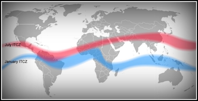
itcz january to july

We had originally planned to head out across the Atlantic in the February/March time frame with a destination of the US east coast, probably the Chesapeake, via Bermuda. That was Plan A. Then, there was Plan B. We'd head out in the April/May timeframe and perhaps head to the southern Carib … Trinidad, maybe. We're now working on Plan C. We'll hang in Namibia … Lüderitz and then Walvis Bay further up the coast … till the August time frame and then head across the Atlantic via St. Helena and Ascension as originally planned. Instead of heading into the Caribbean, we'll head to the Guianas … three small South American countries we've yet to visit. None of these countries suffer from hurricanes … only heat and humidity. They're a good point of sail and on the way, and will provide a good entrance into the Caribbean once the hurricane season has passed. The Chesapeake will have to wait till next Spring.
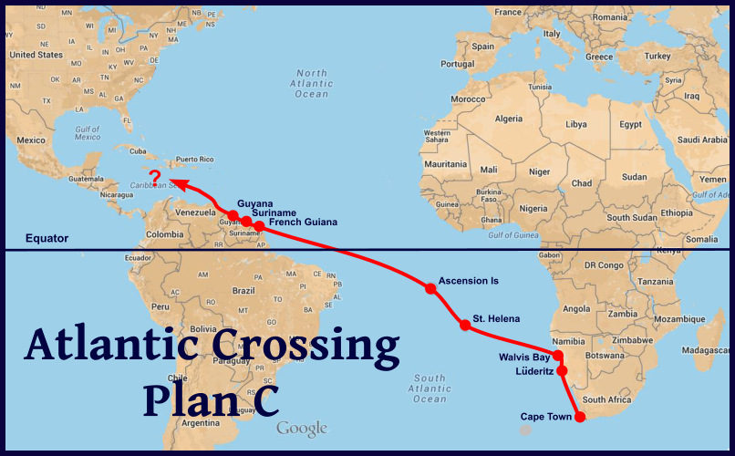
plan c

Being flexible is key when you're cruising … especially on a sailboat. There are times when it's prudent to wait and other times when it makes sense to alter your plans a bit to fit with Mother Nature's plans.

stay flexible

The world is huge when you're sailing and 70+% of it is water. There's always somewhere to go. By the way, we've begun to think of it as being extremely early for next season as opposed to being particularly late for this one. It's all in how you look at it!

Thanks for this blog post idea, Catherine! Anyone else have any ideas for blog post topics? We're wide open to suggestions. Leave a comment or send a quick note via our contact page.
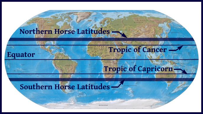
The Blue View - Horse Latitudes

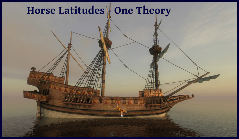
For some odd reason, I always thought the horse latitudes were synonymous with the doldrums near the Equator, but they're not. There are two high pressure bands that lie between 30 and 35 degrees from the equator in both the Northern and Southern hemispheres, which for centuries have been referred to by sailors as the horse latitudes. Both areas experience little or no precipitation, and variable light winds. Sailing vessels were often becalmed in these regions – thus in the north, the area was known as the Calms of Cancer and in the Southern Hemisphere it was known as the Calms of Capricorn. horse latitudes map

The earth also has three bands of low pressure – one near each of the poles and one lying at or near the equator. Since wind flows from a high pressure area to a low pressure area, the areas between the horse latitudes and the equator have much more consistent winds – the trade winds. Likewise, between the horse latitudes and the polar lows, the winds produce the westerlies. Mariners of long ago may not have known what caused the trades and the westerlies, but did know how to take advantage of them. They also knew that they were likely to be becalmed in the horse latitudes, and tried to spend as little time as possible in them.

As an interesting aside, the consistently warm, dry air of these regions are partially responsible for the formation of most of the earth's subtropical deserts; the Sahara, the deserts of the southwestern United States, northern Mexico, and the Middle East in the Northern Hemisphere, and the Kalahari, the Namib, the  Australian, and the Atacama deserts in the Southern Hemisphere.

horse latitudes wind chart

There are several theories about how the horse latitudes got their name. The most prevalent legend is that the Spanish ships often transported horses to their colonies in South America. If they were becalmed for a long period of time in these high pressure areas, fresh water would start running low, and there wasn't enough to spare for the horses. The dead or dying animals would be thrown overboard. I suspect that if the legend is true at all, the horses would have been eaten rather than thrown overboard. Maybe it was named the horse latitudes because it was where the crew got to feast on horse meat instead of the usual limited rations of salted beef.

one theory

Another theory is that the name came from the “dead horse” ritual of sailors. Seamen, when signing on for a voyage, would receive an advance in pay, which was meant to be spent on gear and clothing for the voyage (but more likely was spent on drink and debauchery in the hours before departure). It was usually a month or two into the voyage before the debt was worked off, and this period was called the “dead horse” time. A celebration was often held when the debt was paid off, and it usually corresponded to about the time the ship reached the area of calms.

A third explanation comes from old maritime terminology. A ship is being horsed when it is being carried by a strong current. In an area of light or calm winds, the sea currents and tides would have more effect on the progress of the vessel than the wind. Its forward progress through the horse latitudes would depend on how much it was being horsed.

Whatever the explanation, the horse latitudes in the South Atlantic near Africa are quite narrow and fortunately, our passage is reasonably fast. Whew … that's a relief because we weren't looking forward to eating or throwing any of our horses overboard.

And lest you think we've forgotten, Happy 239th Birthday, America. Though we won't be celebrating with fireworks and family barbeques, we've got the 4th of July spirit aboard Nine of Cups and our American flag is flying.

happy 4th

Cape Town to Luderitz - Days 1-3

to luderitz
Day 1

We were geared for an early start, but at 0500 it was cold, dark and rainy, and we could hear the wind howling. We rolled over and snuggled back in till 0700, when it was still cold and dark, but we couldn't hear rain on the deck any longer and the wind had calmed. The wind was still from the north, but promised to go southerly by mid-morning. We did last minute chores, taking advantage of shore power and heat while we had it. We cast off our shore lines and slid from the berth at the civilized hour of 1030. With three layers of jeans, sweats, foul weather bibs, plus t-neck, fleeces, jacket, woolen socks, gloves hat and scarf, I looked and walked like the Michelin Man, but I was warm. We tidied up, stowed lines and fenders, and set the mainsail while still inside the protection of Duncan Docks, then headed out the channel into Table Bay. The mountain was shrouded in dense fog, its billowing table cloth in place. No last minute, lingering views for us. A bittersweet goodbye to Cape Town, but goodbye it was … at last. The wind had calmed to 4 knots, still from the north. We were motoring, but the bus heater was doing a great job of keeping the cabin toasty and, lacking our sea legs, we were grateful for the calm start of the passage. David paid tribute to Neptune with a generous tot of rum as cormorants and African penguins looked on. Sea lions raised their flippers in farewell. The sun broke through for a quick moment as we passed Robben Island, then was quickly swallowed up by thick clouds. We sipped our hot cuppas and munched on rusks. Having slept poorly during the night coupled with a tab of Stugeron, our seasickness meds, we were happy to get into our nap routine right away.

The night was clear and cold. The near-full moon was a welcome sight and two planets outshone millions of stars. The early morning hour watches are always the toughest. The cold this night was deep and penetrating despite the layers of clothing. The nighttime clarity was suddenly smothered by a pea soup fog which totally enveloped us. I get that claustrophobic feeling when the fog is so thick, like a sea monster is just waiting out there to gobble us up. As I glanced at the Navionics chart on my iPad and constantly checked the radar and AIS, I couldn't help but marvel at how far navigation tools have come, even in the last 15 years.

Day 2

Day's Run: 155 nm

318 nm miles to go at Noon

Getting back into my cold weather gear for the 0600 watch was painful. I was still groggy with sleep or lack thereof. It was cold and the southerly icy breeze slapped my face hard as soon as I climbed into the cockpit. It was still dark, the moon was setting and the stars were low on the horizon. An accumulation of condensation on the bimini became a continuous drip, drip, drip on my head.

The sky began to pink up about 0715 and the sunrise portended a pleasant day ahead. The warm sun rays were soon soaking into my back and coaxing the cold and bad humors out of me. It was gorgeous. Albatross, petrels and shearwaters replaced the normal coastal birds as we veered away from the shoreline. A couple of benign days at the start of a  passage is a godsend when we've been port for so long. We'd taken Stugeron and thus far, neither one of us had been queasy. Though cold, the night watches had gone by quickly enough since we could read, write and play games without getting sick. David commented that it was such a pleasure to be on passage where he could sit and read and not feel guilty that he wasn't doing something productive on the boat.

The wind had finally turned southerly but remained light till mid-day. When we went forward to set the pole, we both felt the first tinge of queasiness, but it subsided when the work was done and we withdrew to the cockpit. Dinner was re-heated Lemay Special and sandwiches. We're both tired and so take full advantage of our nap times. When it's so cold, hot-bunking is the way to go. This evening, the apparent wind increased to 30+ knots with gusts in the 40s. We took a second reef in the mainsail. The waves have increased concurrently and the ride is a bit rougher. Still no puking. All is well.

Day 3

Day's Run:165 nm

153 nm to go at Noon

A quiet night, one ship is all the AIS picked up and it was so far off, I could barely pick it out visually. The setting moon around 0615 was an amazing orange globe in a pitch black sky that seemed to just plop down beyond the horizon, heavy and tired from being out all night.

With the icy Antarctic wind came a biting cold that left me numb after my watch. The waves had increased and we were bouncing around with them. Why not stay below where it's warm? Well, seasickness finally got to me with its signature headache followed by nausea. The Stugeron obviously worked since I wasn't yacking, but I felt miserable and being cold and topside trumped being warm and nauseous and awake below.

When I climbed into the bunk for my 1500 nap, my head was pounding … think migraine. David made dinner at 1800 and gave me another half watch to sleep. What a guy! I felt much recovered when I took over the watch at 1930. I think he wasn't feeling all that well himself since I saw him take another Stugeron as well. We do take care of each other and I must admit that extra half watch and the captain's dinner service was just what the doctor ordered. During this watch, we passed the entrance to the Orange River and entered into Namibian waters.

David's new prop generator is doing a great job. We're getting an extra 8+ amps just sailing along and it's keeping up with the electronics power drain just like it was intended to. In fact, he had to shut off the wind gen earlier because we had too many amps coming in! I'm sure he'll tell you about it in a BV in the near future.

Despite my whinging about the cold, the cabin has stayed warm AND we're making good time. We're hoping that the wind continues as predicted.