Along the Intracoastal Waterway - Day 6
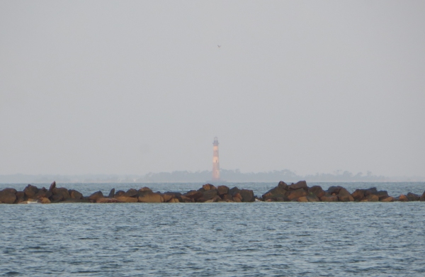
Day 6 – 420 nm to go With regret, we departed from Charleston as the sun rose. Our intent was to continue along the ICW, but the winds were favorable, and the tides and bridge schedules weren't, at least for the day, and so we decided we'd head outside for a change. We traveled down the Cooper, met the Ashley and found the Atlantic Ocean once again. The Charleston Light appeared hazy in the distance behind the rock jetty that lines the channel to the sea.

charleston lighthouse

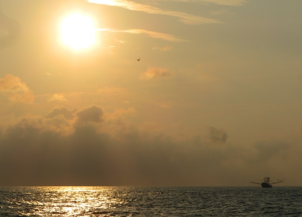
Shrimp boats with dolphins and gulls following their trail, were out in full force as a hot, rising sun melted away the morning haze and we prepared for another sizzling day, but at least we'd have a sea breeze to cool us.

shrimp boat at dawn

We headed out of the Charleston Channel, cleared Rattlesnake Shoals and observed no anchoring or dredging warnings on the charts due to unexploded mines, a remnant of WWI and WWII harbor protection programs. We rounded Cape Romain and headed for the Georgetown Inlet. We only had a one day forecast of favorable winds but had yet to find them. We saw 5-8 knots with gusts of 10-11, but not much more. We were motor-sailing, moving along smartly in the 7s and 8s.

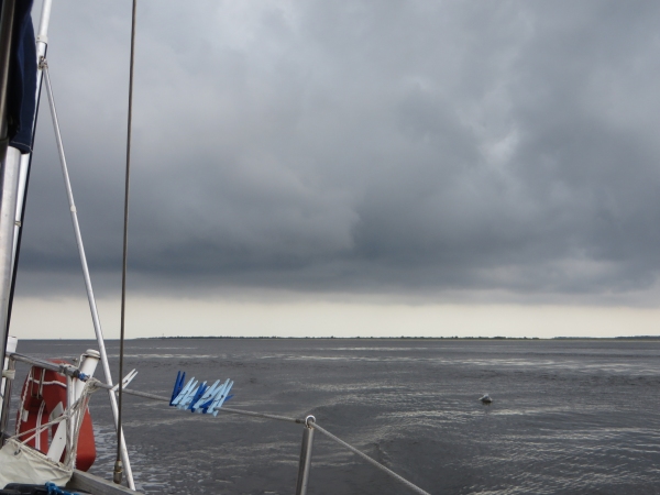
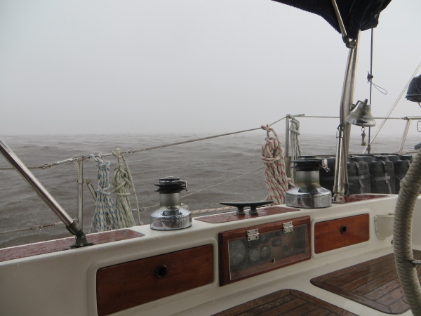
As we headed up the Georgetown Inlet, a long 15nm channel, we began to hear distant rumbles of thunder above the engine roar and the sky began to cloud up. The VHF wailed a weather alert … thunder and lightning cells moving fast and furiously in our area. We could see lightning bolts piercing the blackened sky to the west. The extra iPad and GPS went into the microwave immediately.

blackened sky

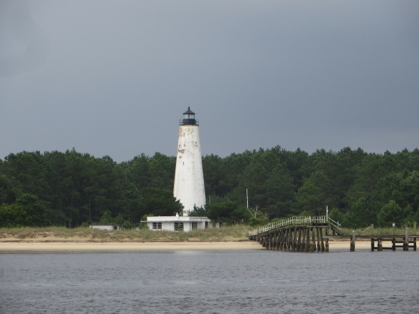
We passed South Carolina's oldest lighthouse, the scenic Georgetown Light, but our minds were concentrated on getting to a secure anchorage before the heavens broke loose.

georgetown lighthouse

We anchored just before the Ocean Highway Bridge in a perfect little spot just off the ICW. We'd no sooner got the anchor down and snubbed than the heavens opened and the decks were washed clean. The thunder and lightning provided a good visual and audio show, but nothing came close enough to be of concern. It blew away in an hour or so, leaving us with a cool sleeping night for a change.

squall

Dinner, a movie and plotting the next day's route took up the rest of the evening and we zonked out shortly after the sun went down. It's amazing how just sitting in the cockpit and steering for 12 hours can tire out a body.

Along the ICW - Arrival in Charleston

Day 5 – 441 nm to go This is our fifth straight day of motoring and still no winds outside in the near forecast. Last night was the hottest and most humid yet and we both woke this morning tired and groggy. We were anchor up by 0630. We were like horses getting close to the barn. We're heading into Charleston, South Carolina today and we have a berth reserved at the Charleston Maritime Center, one of our favorite stops since we started sailing back in 2000.

We are getting into more populated areas now. There are beautiful homes set high along the riverbanks. Each seems to have its own personal long pier that stretches over the marshlands and extends out into the channel.

long piers and big houses

This area of Georgia and the Carolinas is known as “low country” for obvious reasons. Old plantation homes sit side by side with new, humongous, multi-storied, multi-million dollar homes. It's the ramshackle, old boat houses that tend to catch my camera eye though.

old boathouse

The locally-themed weathervanes sit atop the cupolas of the newer boathouses and are very appealing.

weathervanes

Today's adrenaline rush was the Elliott Cut, connecting the Stono River to the Wapoo Creek and the Ashley River. It's very narrow with a current rush up to 5 knots and shallow waters outside the channel. There's a significant amount of trust required to head into a narrow channel based on other people's information and the chartplotter. The anticipation, as is many times the case, was worse than the reality and it was a no-drama event. Thank you, Neptune.

entering elliot cut

We waited for the opening of the Wapoo Creek Bascule Bridge and glided into the traffic of the Ashley River. We rounded the point into the Cooper River, passed historic Castle Pinckney, and headed to the Charleston Maritime Center. The Charleston waterfront was a beautiful sight to see.

charleston waterfront

We slid into our berth on a long floating dock just inside the basin and opposite the fixed dock where the Spirit of South Carolina tallship was moored.

cups tied up at dock

All tied up and tidied up, we took a look at the to-do list, planned our day and headed off to do laundry and take showers. We're only here for two days and we plan to make the most of it.

Just in case you thought we might have forgotten … Happy Father's Day to all you Dads out there!

Intracoastal Waterway - Day 4

Day 4 – 490 nm to go A hot and humid night with nary a breeze and little sleep to be had. We've been checking the weather daily but still no reasonable weather window to get us all the way to the Chesapeake. The winds are either 5-7 knots variable or strong winds from the north … right on the nose. We plan to continue along the ICW, at least to Charleston, SC.

It was easier to get up this morning than to lay awake in our sweaty bunk. We were anchor up by 0620 before the fiery red sun had even cleared the horizon. Another gorgeous sunrise greeted us with birds singing in the tall grass and waders plying the sandy shore. Pelicans circled, poised to plunge as soon as they sighted a possible snack. Dolphins were already making their rounds through the feeding grounds.

sun on the horizon

We've had our share of minor repair issues along the way. The tachometer has been flaky. The speed transducer hasn't been working and the wind vane direction is stuck permanently reading “N”. David wiggled wires for the tach, but it didn't do any good, so that will wait till we're in port. He has no plans to go up the mast at the moment, so we'll just check the flag to see which way the wind is blowing. He'll pull the speed transducer tonight to free it up.

The landscape is slowly changing. Instead of miles and miles of flat, grassy lowlands, we're beginning to see a background of more trees, a nice break in the scenery. We crossed Calibogue Sound and then across the Hilton Head Inlet. By 10am, we crossed into South Carolina.

now there's trees

One thing about the ICW that is a pain is the number of bridges we must negotiate along the way. There are some 144 bridges along the entire 1,243.8 SM (1080.8 NM) route, almost half of which were south of us in Florida. We figure we still have to negotiate 74 bridges and one set of locks. Depending on wind, current, weather and the type of bridge, this can be easy or challenging.

The fixed span bridges on the ICW are at least 65' MHHW. In other words, at the highest tide, there's still 65' from the center span of the bridge to the water. Our mast with antenna is 63', so we have 24” to spare. It never looks as if the bridge is tall enough. Tide gauge boards are usually posted on the fenders on the north and south sides of the span entrance showing the current allowable mast height.

tide gauge boards

The more challenging bridges are the opening varieties. They have varying opening times and requests for openings must be made to the local bridgemaster on a designated VHF channel (usually 09 or 13). Some bridges open on demand; others only open on the hour or half hour and sometimes not at all during heavy traffic times (0700-0900 and 1600-1800). We had downloaded a 2016 bridge list and referred to it frequently throughout our ICW passage. The timing of the bridge openings isn't the issue other than it can be inconvenient to hang out for another half hour if you've just missed a bridge opening by 3 minutes or so.

The biggest problem is that there are several different types of opening bridges and they all pose their own particular set of problems. For instance, the Causton Bluff Bridge/ aka Sam Vernadoe Bridge is a twin, double-leaf bascule bridge and the left section of the second set of leaves was not in operation, making the opening single leaf and quite a bit narrower.

sam varnedoe bridge

The Ladies' Island Bridge is a swing bridge and when it opens, it reveals two transit lanes through the bridge. We were all lined up to go through, but mistimed how long it took the bridge to open. Another boat was just off our stern and we were too close to the bridge which hadn't fully opened. We had no room to reverse without hitting our tailgating friend. Instead, David made a last minute hard turn to port and had to turn around and get to the back of the transit line quickly in order to make it through the bridge without delay. No big deal, but it was a bit trying to the nerves.

ladies island bridge

The Sister's Creek Bridge is a bascule bridge, but a new fixed bridge was under construction directly behind it. We waited till the bascule bridge opened, then immediately went under the under-construction span. Sometimes there are cables and wires strung across as well. It's always a bit nerve-wracking; nothing major, just a bit of angst. But then what kind of an adventure would it be without a little excitement and a few complaints?

sisters creek bridge

We found a pleasant anchorage near Church Creek, dropped the hook and enjoyed a calm evening.

We continue on tomorrow to one of our favorite east coast cities, Charleston, South Carolina for a welcome couple of days relaxation and Southern hospitality.