Intracoastal Waterway - Day 9

Stuck in Swansboro

Day 9 – 206 nm to go

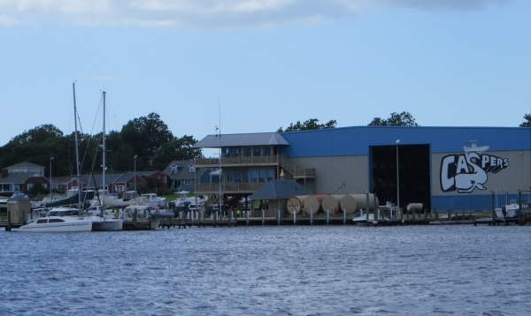
With a forecast of gale force winds offshore and high winds and rainy weather inland, we decided we'd take a day off and stay put in our pleasant little anchorage just off Swansboro Village. Launching the dinghy would have been akin to flying a kite, so we happily stayed aboard for the day. Thanks to nearby Caspers Marina, we enjoyed free wifi all day. Though we didn't get into the village at all, we think it's probably a hopping place as the music went on both nights we were anchored here till well into the wee hours of the morning.

caspers marina on the intracoastal waterway

As it turned out, the day was sunny, but blustery. Not a drop of rain fell, but the wind howled. With good internet, we spent the day writing, catching up on articles and blogs, photo editing, doing some minor chores and just hanging out. It's quite pleasant to just “be” in a place some days with no agenda.

wind blown flag on the intracoastal waterway

This is probably a good day to talk about what we've learned … and re-learned/remembered … while traveling on the  ICW. Granted, our previous experience on the ICW has been extremely limited, but usual navigation skills and rules of the road apply, as well as boating etiquette. It's just that when we're at sea, we don't have the opportunity to use some of these skills much, so this has been a welcome refresher course for us.

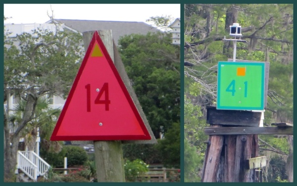
Something new we learned … all ICW navigation markers are marked with a either a yellow rectangle (for green markers) or a yellow triangle (for red markers), so at a waterway intersection, sailors always know which direction the ICW is going. Clever, huh?

markers along the intracoastal waterway

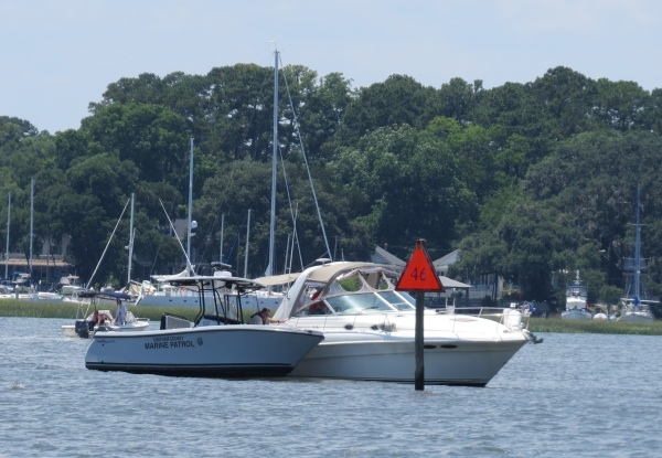
Something we remembered … there are still lots of courteous cruisers out there. Larger motor vessels will hail their intentions to pass us and give us a “slow pass” to minimize their wake as they're going by. If motor vessels are going too fast, especially in no-wake zones in towns, the local marine police stop and ticket them.

marine police on the intracoastal waterway

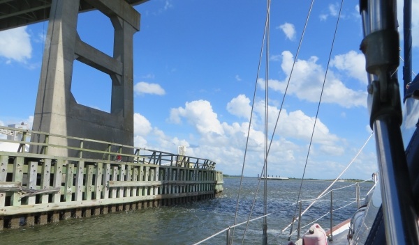
Something we're remembering/relearning … the timing for negotiating transit through opening bridges. We don't pass under or through bridges very frequently on ocean passages. How long does it take the bridge keeper to stop traffic, ring his bell and siren and activate the bridge opening. And then, just how long does it take the bascule leaves to raise or the swing bridge to swing? How does passing under a fixed bridge affect the control of the boat? There is usually a loss of wind, then a gust on the other side and then there's the current and numerous little eddies to contend with. We were a bit rusty, but with  ~70 bridges to transit during this passage, we got it figured out once again. Bridge tenders, by the way, have been courteous, friendly and efficient which has been most appreciated.

a bridge on the intracoastal waterway

Something we forgot … when out of the USA, we rarely have help with lines or docking and tipping is not the usual protocol, nor expected ... even in restaurants. So to the young man at Osprey Marina who was so helpful and accommodating … we didn't mean to stiff you on your tip, we really did forget.

Something I noted … taking pictures from a moving boat is pretty tricky. Taking pictures of moving things from a moving boat … pretty marginal results. That's my story and I'm sticking to it.

Intracoastal Waterway - Day 8

Day 8 – 274 nm to go Today was one of the more challenging days on the ICW. The lengthening days have been working to our advantage. We're up at 0515 and anchor up by 0545. We witness spectacular sunrise after sunrise. The rising tide gave us a good push this morning up the Cape Fear River. All was calm and we were on our way. Despite the shining sun, a long, compact, cigar-shaped roll cloud came into view in front of us, reminiscent of the roll cloud we experienced for the first time in the Great Australian Bight. Within seconds, nearly 30 knots of wind barreled through the rigging and pommeled us for 3-4 minutes, then departed as quickly as it had arrived, apparently planning to harass some other unsuspecting sailor down the river. A good morning, adrenaline rush of a wake-up call to start our day.

roll cloud on the intracoastal waterway

From the Cape Fear River, we transited Snow's Cut to the New River. One of the main bugaboos of today's passage was the number of opening bridges we had to deal with, all with differing schedules. Two bridges opened only on the hour and two opened on the hour and half hour. There wasn't time to coordinate openings from bridge to bridge, so there was a lot of waiting involved. We wasted a significant amount of time treading water waiting at one bridge, then we'd speed up to get to the next, only to be disappointed by missing the opening by a few minutes and waiting until the next opening. Boats don't stop. They float and drift around with the wind, current, wakes and waves and constant maneuvering is required to keep them in place. Staying put for a boat is akin to keeping an impatient toddler in place.

bridge on the intracoastal waterway

There was also constant shoaling along our route today, especially at inlets from the sea. Despite having foreknowledge from the Active Captain comments, we went aground at Masonboro Inlet. We were in the middle of the channel, but obviously got too close to the green side. (For non-sailors, red is the port (left) side and green is the starboard (right) side … at least when we're heading north up the ICW. Red and green markers indicate the position of the channel.) The sand was soft and David worked us free in a matter of minutes and we were on our way.

The second grounding came about an hour later and again at an inlet. This time the Mason Inlet was the culprit and getting off this sand was not as easy, especially since we were on a falling tide. It took us over 30 minutes of working back and forth and side to side before we found enough water to get off the grounding, out of the shallow area and back on track. Again, we were in the channel, but obviously just not in the right spot. Though challenging, time-wasting and frustrating, going aground in sand and mud is not that big a deal. The sand tends to scrape the barnacles off the keel, but not much more than that. If worse came to worse, we could have called Towboat US to which we subscribe. Many folks do, but the captain preferred to hone his “going aground extrication” techniques and this was a good opportunity. Again, no kedging off, no launching of the dinghy, but those ideas were ready if we needed them. We watched a young fellow poling his john boat through the shallows a little while later and we didn't feel so bad. They say “ it's not IF you go aground, it's just WHEN you go aground.”

poling a john boat on the intracoastal waterway

The last of the bridges for the day was the Onslow Beach Swing Bridge. We timed it well for a change and passed through at 5:30pm. The US Marine training facility, Camp LeJeune, is in this area and from time to time live firing exercises are under way. At those times, the bridge is closed until the exercises are completed, usually several hours.

live firing on the intracoastal waterway

Lucky for us, all was calm at Camp LeJeune, though we did see some marines and military equipment on the shore.

military on the intracoastal waterway

The winds increased throughout the day. We saw a steady 20 knots by late afternoon. The forecast is calling for strong north/northeast winds along the coast and inland coastal waters, so we were looking for a protected anchorage in which to hunker down for a day or two, if necessary. At sea, 20-25 knot winds aren't a problem, but inland on narrow waterways with significant shoaling, the wind makes maneuvering a bit trickier.

Swansboro Village was our anchorage of choice. Literally just a few hundred feet off the ICW, we found a 15' spot with good holding just opposite the town dock. By the time we were settled in, the rigging was rattling and the wind was howling in the high 20s from the north. The temperature plummeted nearly 20 degrees to a wonderfully comfortable level. We were in need of a day off to catch up on writing and just relax a bit. We'll take advantage of this opportunity and blame it on the weather.

swansboro village

Intracoastal Waterway - Day 7

Day 7 – 365 nm to go We were up with the sun once again and plying our way up the Waccamaw River. We were under the fixed Ocean Highway Bridge by just after 0630. Yes, there was another beautiful sunrise. Yes, I took a photo or two … and yes, I'm sharing the best one. Some things (and people) are very predictable.

sunrise on the intracoastal waterway

We passed by the entrance to Georgetown, noting that it would make a fine stop on our southern transit next season. The area was known in the past for “Carolina gold”, i.e. rice fields, and indigo plantations … and, also, alligators. No swimming. The rice fields still stretch for acres and acres, but more noticeable is the acrid smell of paper mills and the smokestacks on the horizon.

rice fields along the intracoastal waterway

The Waccamaw River is wide and deep and it was a pleasure to be on it so early in the morning. The landscape has changed once again. The Waccamaw National Wildlife Refuge, a 55,000 acre reserve, borders the rugged eastern bank of the ICW. Forested wetlands, tidal marshes and pine forests are home to a wide variety of native bird, fish and mammal species including red fox and black bear. Having a canoe to paddle around in the tiny inlets and streams would be perfect. Spanish moss aka Old Man's Beard, hangs from the trees and provided a lasting image of this picturesque area in my mind.

spanish moss along the intracoastal waterway

The water here is the color of iced tea … tannic from the heavy tree growth on and near the riverbanks. We could see the brown water lapping against the shore. Tannin is a naturally occurring substance and isn't usually harmful, just not very appealing. Cruisers who travel the ICW regularly refer to it as the “ICW mustache” because it leaves a brown stain on white boat hulls.

intracoastal waterway mustache

By 0930 the bright sunny day had disappeared, leaving a dull, gray, overcast sky in its wake. Motoring as we're doing requires fuel, a rather unusual occurrence for us. We'd passed up several fuel stops along the way in favor of the highly recommended Osprey Marina ... “cheapest fuel on the ICW”. The entry channel was narrow and a bit dicey for Nine of Cups, but we arrived unscathed at the fuel dock where a friendly and efficient dockhand helped with lines, a fill-up (at a bargain price), some ice and an uneventful send-off back down the channel. We were back on the ICW in less than an hour. Interestingly enough, marina signs and fuel prices are advertised along the ICW and reminded us of the old billboards on US highways in days gone by.

osprey marina along the intracoastal waterway

Ospreys are absolutely everywhere along the ICW waterways. We saw them in trees, on docks and flying above us. They particularly like building their huge, terribly untidy nests on the post markers. It was unusual to see a marker without an occupied osprey nest.

osprey nest on the intracoastal waterway

We left the quiet, solitude of the wildlife refuge and headed towards Myrtle Beach. The river traffic increased significantly. We now shared the river with barges and tugs, pontoon boats and speedboats. coast gaurd barge on the intracoastal waterway

We knew we'd arrived at the most congested area when the jet skis, like a swarm of gnats, descended upon us. They travel fast, swerve and spray, make wakes, are noisy and annoy us significantly. We have little tolerance for them, but of course, each to his own and they have as much right on the rivers as we do. We just wish they were a bit more aware of the nuisance they cause.

jet skier on the intracoastal waterway

The adrenaline rush of the day, not counting the 13 bridges we had to pass through, was transiting “the Rockpile”, an infamous stretch of the ICW with rock ledges at the narrow river's edge that jut out precariously into the channel. We managed to get through without harm or foul and continued on across the Little River Inlet into North Carolina and up the Cape Fear River. Our anchorage for the evening is known as Tina's Pocket, a little spot just behind the channel leading light towers to drop the hook off the Cape Fear River.

danger rocks

IMG_0008

It had been a long, 14-hour day. After charting and dinner, we attempted to watch Nick Nolte and Robert DeNiro in Cape Fear. We were highly unsuccessful in this endeavor. We woke each other up half way through and called it a night.