

The Society Islands - Iles Sous le Vent (The Leewards)
In the austral winter, especially in the months of July and August, southeast winds of 25 to 35 knots called maraamu can occur with some regularity in the Society leeward islands, bringing with them ocean swells of 10-12 feet. We had a good weather window, however, and enjoyed a calm, windless overnight motor-sail of 110 nm with a full moon and a mackerel sky. We arrived at Huahine around Noon. The cut through the reef at Passe Avapehi was uneventful despite rain showers and SE winds that kicked up to 30 kts (a maraamu) as we approached. A long, well-marked channel inside the barrier reef led us to lovely, well-protected Port Bourayne where we anchored in nearly 100'. There were only a couple of other boats in the bay and despite our pleasant feeling of being a bit remote, we found we once again had wifi on the boat! Life is good.


Baie Bourayne, Huahine
16S45.98 / 151W01.79 (Lat and Long
Like Tahiti, Huahine's two islands are connected by a narrow little isthmus. The north island is Huahine Nui (big Huahine) and the south island is Huahine Iti (little Huahine). The story goes that the demigod Hiro's canoe cut this strait.
We anchored for two days in Baie Bourayne... relaxing and doing some chores the first day, just happy to be moving again. The second day, we took the dinghy across the bay and under the little bridge at the isthmus that connects Huahine-Nui with Huahine-Iti and crossed Maroe Bay. We left the dinghy near a little village and walked up to the Belvedere (a 15% grade... ugh!) and then on to the village of Faie.

The bridge that connects Huahine-Nui with Huahine-Iti

The view from the top of the pass over the mountain was stupendous
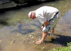
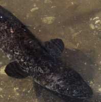
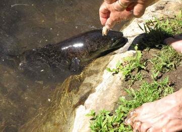
I had an ulterior motive for wanting to walk to the little village of Faie. It's the home of the sacred, blue-eyed eels. I kid you not. These guys are famous and because they're so sacred, they're very well fed. We joined with the other tourists, bought a can of mackerel and, since I was the photographer and could not go into the water lest the camera would get wet, I took photos while David waded in with his can of mackerel and announced chow time to the eels by slapping the water and dribbling mackerel juice to aid the process. My, oh, my...what a sight as these meter-long eels came from under every rock and cranny in this tiny, muddy stream to see what treats David had in store for them. They mistook his white toes for mackerel at one point and began nipping, so he promptly got back on shore and as you can see, they followed him.
Islanders say the eels, which have been on Huahine as long as man, keep the waters clean and free of pollution, eating rubbish and bacteria that grow in the riverbed. Legend holds that it was these eels that brought fresh water to the village.
Fare
16S42.80 /151W02.25

The next day we moved the boat to the largest village of Huahine, Fare.

Boat anchorage off Fare, Huahine. In the distance, the islands of Raiatea and Tahaa are in view.

The quay along the waterfront was lovely.

Main Street, Fare, Huahine

Saturday market day in downtown Fare. The nearby SuperFare supermarket was a huge warren of aisles, nooks and crannies and carried just about everything and anything you'd want.

LeTruck, the local transit system, seemed to have no posted schedule. Only the drivers knew when and where they were going.
We walked the six+ kilometers to the little village of Maeva, noted for its plethora of marae, places reserved for religious and social ceremonial activities. In this area alone, there were 20 marae, all quite accessible and in differing states of repair. These were constructed by the different
district chiefs as places for people to meet and worship their ancestors. Archeologists date activity in this area as early as 850 A.D. Those marae along the banks of the Lake Fauna Nui were interesting and saved us the climb into the hills on a hot, humid day.

A fan palm, also known as a Traveler's Tree, outside the post office.

Informative signs (in French, English and Tahitian) provided lots of information about marae.

We stopped at the Fare Pote'e which is a replica of an original community building associated with the marae.

The "unu" were particularly interesting. Carved wooden planks, brightly colored with intricate patterns and carved zoomorphic and anthropomorphic images of family guardians and ancestors, e.g. totems.

Ancient stone and coral fish traps still in use today as they were generations ago.

picturesque views everywhere

A monument to the French who died here in 1846 in the Battle of Maeva when the islanders successfully defended their independence.

Raiatea in view
From the anchorage, our next island stop, Raiatea, is in clear view. Only 21 miles away, it's a straight shot out of Huahine's Avamou Pass across the bay into Raiatea's Teavapiti Pass and an anchorage near the village of Uturoa. Once again, no wind, so we motored on a lovely day. Quick trips between islands reminded us of our time in the eastern Carib.
Uturoa, Raiatea
16S43.67 / 151.26.36
At 66 sq miles, Raiatea is the second largest island of French Polynesia. It was traditionally the ancient "Havai'i", the sacred isle from which all of eastern Polynesia was colonized. Raiatea shares a lagoon with its northern sister, Taha'a. Legend tells how the two islands were cut apart by a mythical eel (eels again!).


Entering the lagoon through Teavapiti Pass

The deep anchorage in front of Uturoa.

Uturoa is the administrative center of the leeward islands. Though small, it's quite modern with a great supermarket, fuel dock and large municipal quay.

Flat-topped Tapioi Hill (956') provides the backdrop for the local yacht club.
Baie Haamene, Taha'a
16S38.24 / 151W29.16 (Lat and Long)
We didn't spend much time at Raiatea. We re-provisioned a bit at the Champion Supermarket, filled our water jugs for laundry water and then headed back to the boat. A cruise ship had just arrived and the town was overwhelmed by its passengers. Our next stop was across the lagoon, around the Grand Banc Centrale to Baie Haamene in Taha'a.
Taha'a is known as the vanilla island because it produces 70% of the territory's "black gold". Vanilla, a vine belonging to the orchid family, is grown on small family plantations here. Brought to Tahiti from Manila in 1848, the aromatic Tahitensis type originated from a mutation of the original plant. All plants must be hand-pollinated, then harvested between April and June. The pods are then put out to dry for a couple of months. This extremely labor intensive process accounts for the high price charged for real vanilla products. In fact, it's one of the world's most expensive spices.


Taha'a is considered "off the beaten track"
since it has no airport and is less built up than its neighbors. Just our kind of place.

Entering Baie Haamene, the longest inlet on the island, quite well protected and beautiful. The little village of Haamene lies at the head of the bay with a considerably shallower anchorage (40') than we'd seen in awhile.

The red steeple of this pretty little church on Taha'a's west side is a landmark for folks heading into the lagoon through Pass PaiPai.
Unfortunately, time was running out for us. Our visas were expiring soon and we needed to leave French Polynesia. Never enough time, it seems. After only a couple of days in Taha'a, we headed to Bora Bora, our last stop in French Polynesia.
Bora Bora Yacht Club, Bora Bora
16S29.28 / 151W45.65 (Lat and Long)
The original name for Bora Bora was Pora Pora because no "B" sound exists in the Polynesian language

Heading out through Pass PaiPai was a bit oisterous. After a few bumps, we were through the pass, in deep water again and all calmed down for the 30+ nm trip to Bora Bora.

The trip from Taha'a to Bora Bora was pleasant enough though we had little wind and big swells. A large vibrant green cloud lay over Bora Bora's lagoon; we thought it might be a reflection of the turquoise green water below. The green cloud was soon overtaken by huge black clouds and rain as we approached the entrance to Bora Bora's only pass, Te Ava Nui. As usual, we had quite a bit of trepidation about traversing it, but after a few bumps, we were through the pass and picking up a mooring at the Bora Bora Yacht Club.

We walked the mile+ into the little village of Vaitape to explore a bit and buy a few groceries. The road to town was narrow with no sidewalk, almost no shoulder and lots of traffic. Vaitape was crowded with cruise ship tourists, lots of traffic and otherwise not much Polynesian flavor. We did have the chance to catch up on emails at an internet cafe, however.

NASA aerial view of Bora Bora

Nine of Cups sits comfortably on a mooring with the peak of Mataihua and the Bora Bora Yacht Club.
The clock continued to tick and our visas were expiring. When a weather window presented itself, we left Bora Bora with reluctance and headed to the Cook Islands, where we had a number of adventures. Come join us…