

Bass Strait Islands - Tasmania's hidden gems
The Bass Strait is a sea strait separating Tasmania from the south of the Australian mainland. As if Tasmania isn't exotic and isolated enough, several of the islands on its north coast in the Bass Strait are only accessible by boat and helicopter.

The International Hydrographic Organization defines the limits of the Bass Strait as:
On the West. The Eastern limit of the Great Australian Bight
On the East. The Western limit of the Tasman Sea between Gabo Island and Eddystone Point
Named after George Bass after he and Matthew Flinders passed through it while circumnavigating Van Diemen's Land (Tasmania) in the Norfolk in 1798–99. At Flinders' recommendation in 1800, the Governor of New South Wales named the stretch of water between the mainland and Tasmania "Basses Strait". from Wikipedia
Note: The above Expedia map shows the Indian Ocean extending
into the Great Australian Bight meeting with the Pacific, but ALL
Australian maps show this area as the Southern Ocean!
Approximately 240 km wide at its narrowest point and generally around 50 meters deep, the Strait contains over 50 islands, the largest of which are:
King Island
Three Hummock Island
Hunter Island
Robbins Island
Furneaux Group
Flinders Island
Cape Barren Island
Clark Island
Kent Group: Deal Island and 3 smaller islands
Hogan Island
Curtis Island
Many vessels, some quite large, have disappeared without trace, or left scant evidence of their passing. Despite myths and legends of piracy, wrecking and alleged supernatural phenomena akin to those of the Bermuda Triangle, such disappearances can be invariably ascribed to treacherous combinations of wind and sea conditions, and the numerous semi-submerged rocks and reefs within the Straits.

Islands of the Bass Strait
On the recommendation of many previous visitors and especially after our visit to the Gippsland Lakes, we headed towards Tasmania with a planned stop at Deal Island along the way. The lighthouse/island caretakers on Deal Island, David & Mary Nicholson, are good friends to many Raymond Islanders and by extension, became our friends. We phoned in advance to determine what, if any, supplies they needed. Fresh lemons, oranges and a few grocery items were on the list and we loaded them aboard Nine of Cups. We headed out Lakes Entrance to Deal Island about 100 miles S/SW with good winds to carry us.
Deal Island's area is about 1,450 hectares (3,635 acres), consisting of granite cliffs rising to 260 metres on the southern side, gradually descending over the island northwards in rolling hills and grasslands to several white sandy beaches. The interior of the island consists of limestone layers with a thin layer of top soil on the upper reaches.

Threading our way through the oil platforms in the middle of the Bass Strait was reminiscent of sailing through the Gulf of Mexico on our first offshore passage back in 2000.

Our approach at dawn gave us a great view of the Murray Channel separating Deal Island to the left and Erith Island to the right.

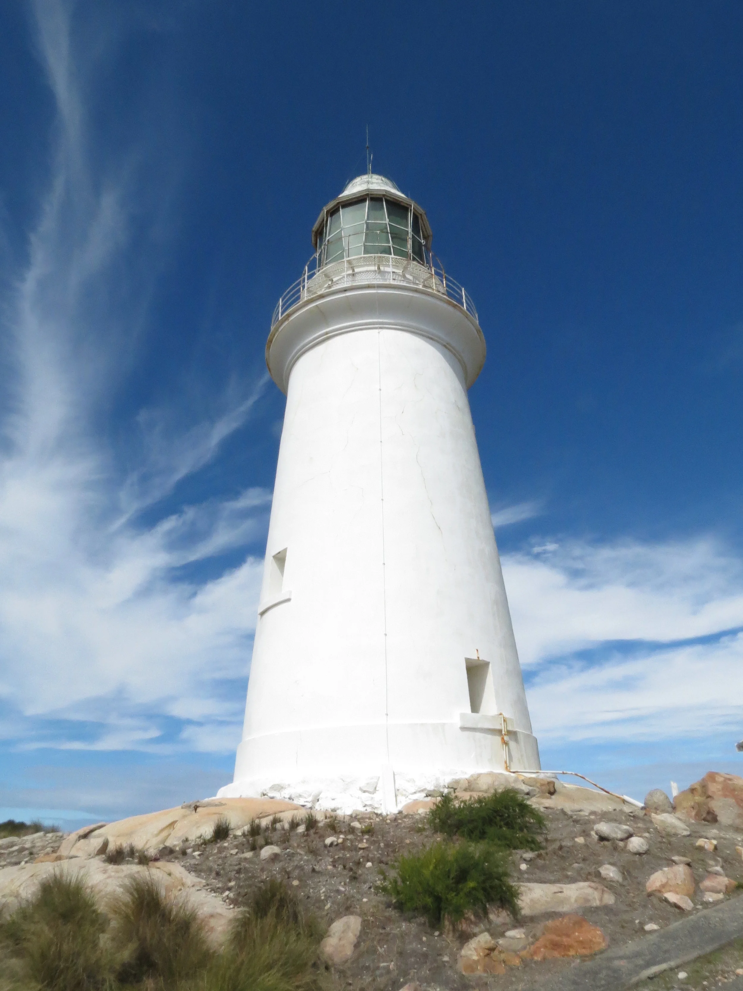
The Deal Island Lighthouse rises in the distance.

A welcome sign outlines the exclusion areas for the Kent Group which means no fishing/ shelling and also notes shipwreck locations.

We thought we saw wallabies on shore as we were anchoring, but weren't sure. Once ashore, they were literally everywhere.
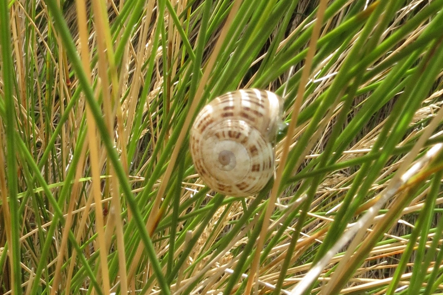
We noticed snails that clung to the tall blades of tussock grass that line the path.

Climbing the steep hill to the compound above afforded us lots of beautiful views of
Cups at anchor.
A volunteer caretaker program to maintain a residential presence on the island has operated successfully since 2000. The volunteers are selected based on their ability to live in an isolated location and their skill sets necessary to undertake the various programs required to manage the island. They are asked to stay for 3-month stints. At the Management Authority's expense, they are provided with transport to and from the island and reside in the former headkeeper's house. Power is generated by a large solar panel array with a diesel generator for backup. They must buy their own provisions and they receive no compensation. There's a waiting list of candidates. Mary & David completed one tour and then were asked to do another...and another.

Mary & David Nicholson, Deal Island caretakers and our island hosts, came aboard Nine of Cups for dinner one night.
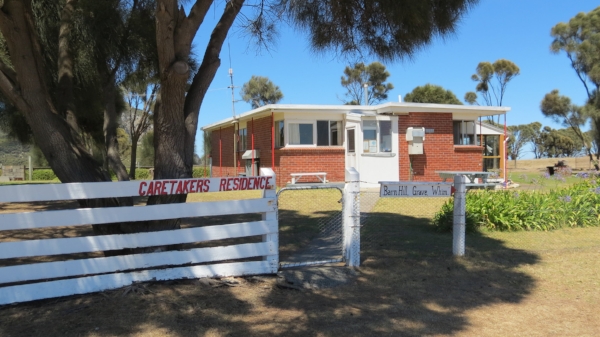
The brick caretaker's house was built in 1962 and previously used as a keepers residence. It is neat, tidy, sturdy and comfortable.
The caretaker's garden looked lush and productive. Each caretaker couple plants and maintains a garden for the benefit of the next couple to arrive so there are always fresh veggies and herbs available. A supply boat comes once every 3 months.

Mary returns from weedwhacking one of
the many island paths.

The two Davids in the compound workshop trying to repair a non-working chainsaw.

Marcie promised haircuts for the Davids and Mary. They all commented it was the most beautiful haircut venue ever.
Our first foray on the island was to climb up to the lighthouse, some 3.5km away from the compound on a steep track.
The Deal Island Light was first opened in 1848 and manned through 1992, when it was closed. Built on a promontory, it is the highest lighthouse in Australia, standing 320 metres above sea level, even though the lighthouse itself is only 20 metres tall! It was so tall that 30% of the time, its light was obscured by fog and clouds.

Unlike many lighthouses, Deal Island Light allows visitors inside for an up close and personal look.

Standing out on the balcony of the lighthouse, the wind and the views took our breath away.

Foundations of the old buildings viewed
from the top of the lighthouse.

As anticipated, the views from the top were fantastic.

Not only could we climb up the steep spiral stairs inside the lighthouse, we climbed inside the lens! Deal Island David took our photos of us inside, outside and around the lighthouse. We definitely gave it a thorough investigation.

Hamming it up standing outside the lens
for a distorted, refractive mug shot.

Deal Island has the best group of Georgian style lightstation buildings still extant in Australia. The original Superintendent's cottage with its yard sheds and privy is the oldest surviving lightkeeper's dwelling in Australia. Now used as the island's museum, it, too, is open to visitors.

Marcie and her little friend pose on the museum steps. For the most part, the wallabies inside the main building compound were pretty tolerant of us humans and barely noticed when we walked past.

A flame robin perched atop the direction sign was obviously offering tourist information if required.


An old spigot drips constantly providing the wallabies and Cape Barren geese with fresh drinking water. We noted they tolerated each other's company quite well and took turns getting their drinks.

Over 100 different bird species have been recorded on the island including the Beautiful Firetail, a finch, pictured above.

A honeyeater enjoys the agapanthus blooming in the flower garden.

Huge Pacific gulls roamed the beaches
and floated near the boat asking for snacks.
Each day, we chose another track to follow at David & Mary's suggestion.

Dragon's Tail

Little Squally Bay

the "whim", an animal- powered winching system to bring cargo up from the loading dock

A skull at Garden Cove, a reminder of the cattle which once grazed on the island.
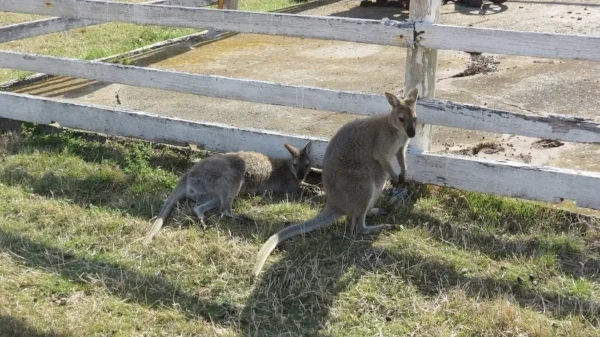
We were concerned that we wouldn't see very many wallabies, but no worries. They were literally...everywhere. The wallabies here are Bennett's wallabies and most adults are probably about 1 meter tall. They loll around during the day, finding shade under trees or near buildings in the compound. They're grazers and feed on the island grasses.


According to the Nicholsons, there are ~200 little penguins that return to the island each evening at dusk to their mates, nests and babies and leave again each morning at dawn. Little penguins are also known as blue penguins or fairy penguins. One night, we joined David & Mary ashore and watched the penguins' arduous journey from the shore, up the steep hill to their nests in the grass and rocks.


Brushtail possum are nocturnal critters. They vied for our attention as we watched the penguins. They're cheeky little guys, not afraid of humans and always looking for a handout.


The island tracks are well-kept and diverse, each offering a different view of the island, its flora and fauna.

Butterflies were abundant. Above, a geitoneura klugi ( we think ).

The island has over 300 recorded plant species including two species endemic to Tasmania and eight species considered to be threatened.

Sea spurge is an invasive species which
threatens native vegetation.

There are several graves on the island. Above one marked simply "Baby".

Barn Hill offered particularly great vistas especially of the compound buildings far below with just a bit of East Cove peeking through.

This vantage point above the whim, shows the Erith Island and its attachment to Dover Island at low tide as well as Hogan Island in the distance.

David adds "our" rock to the cairn on the top of Barn Hill.
Beyond wallabies and penguins, natural beauty and vistas, our visit to Deal Island would have been much less rewarding without the recommendations and help provided by its caretakers, David & Mary Nicholson. Their overwhelming hospitality and caring attitude about Deal Island was outstanding and remains a vital part of our Deal Island memories.
Erith Island
We moved from East Cove on Deal Island to West Cove on Erith Island in hopes of sitting out a big westerly blow. The holding was not as good as we'd hoped and the notch in the hills allow wind blasts of 50 kts to pommel us. We left hours after anchoring and headed to Winter Cove on Deal Island's east coast...a much better option.

Okay...it wasn't 50 kts...only 49.1

From our anchorage, we could see the rough shack of the Erith Island Mob, as they're known. The Murray-Smith family has been coming to Erith Island and caring for it for the past 50 years.

A view of the anchorage and Murray Channel during a near-50 kt blast of wind. Coupled with the heavy rain, it was not the most pleasant venue.


When we returned to East Cove after the blow, to our surprise, more boats had arrived and we were invited to a BBQ at the wharf. We joined about 15 people at the BBQ/picnic area where a wood-fired BBQ grill served us well.
In January 2012, we headed from Deal Island to the west coast of Tasmania. It was a wild ride to Macquarie Harbour through Hell's Gates to Strahan and up the Gordon River. Then Port Davey, around Southeast Cap (another of the World's Five Great Southern Capes) and up Tasmania's East Coast.
Fast forward to January 2013 which found us heading from Hobart further up Tasmania's East Coast with visits to Bruny Island, Port Arthur and Maria Island. Finally, we headed back to the Bass Strait completing our circumnavigation of Tasmania. We spent precious little time in the Furneaux Island Group. Weather and time precluded a longer stay, but here's a glimpse of what we missed.
Inner Sister Island - Furneaux Island Group
39S42.07 / 147E54.76


The moderate south winds forecast for our passage north turned out to be gale force winds with gusts clocked at 56 knots. The ocean changed from peaceful and bird-rich, to tumultuous and angry with big following seas. We missed our opportunity to call in at Lady Barron port on Flinders Island because of the weather and seas. Instead, we dropped the anchor in a little notch on the south side of Inner Sister Island for the night. The swell drove us out early the next morning.
Return to Deal Island

I woke up this morning and watched a wallaby hop across a sandy white beach while I sipped my tea. Another two hopped along in his tracks, causing the Caspian terns to screech when they had to move.

Part of the magic of Deal Island is its location in the middle of the notorious Bass Strait. It is only accessible by boat although helicopters can land on top if there is an emergency. That's rare. The park is manned by volunteer caretakers who spend three month terms here, welcoming guests and generally taking care of the island and its buildings during their watch.
We beached the dinghy and walked halfway up the steep hill to the “Telstra bench”, strategically located in order manage a signal to the mainland through the notch that separates Erith Island and Dover Island across the Channel.

At the top of the steep, switchbacked hill, lies the fenced “Compound”. Most of the island's buildings are located here including the Caretaker's Residence. We tried to avoid upsetting wallabies and Cape Barren geese along the way, but it's nearly impossible. They're everywhere. Marie, Tom and 7-year old, Floyd, were waiting for us and welcomed us warmly.

Though we'd visited before, we checked out the tiny museum once again. It's full of information about the island and memorabilia from lighthouse keepers past. Antique bottles, shards of china, interesting shells collected on the beach, bits of machinery and sepia photos, all found their place in the old lighthouse keepers home.

David was interested in the huge solar panel display … 56 panels at 210 watts each. They rely on solar as their only means of power on the island and it seems to do the trick.

The animals hold the
most allure for me
Flame robins and firetails, welcome swallows and silver eyes flit about. Cape Barren geese roam everywhere. Ducks swim along the shore and mingle with terns, gulls and oystercatchers. We've watched the little blue penguins coming home to their nests at dusk after a long day at sea. Wallabies, like half-pint kangaroos, are everywhere. They lounge under trees, munch on the tussock grass along the path, play on the beach and generally have the run of the island.


They tend to startle you as you're walking and jump out in the path beside you, usually startling themselves as well. They sometimes hide their heads in the tussock grass, but their long tails and bums stick out. I guess they reason that if they can't see us, we probably can't see them.

Walking the well-worn paths on the island, visiting the museum, seeing the lighthouse and the graves, conjures up all sorts of images of the lives that were led here and of the ordeals and hardships faced. We feel privileged to have experienced this place, not once, but twice. The magic never seems to wear off.
A Better Look at Erith Island
39S27.39 / 147E17.91
Erith Island, along with Deal and Dover Islands, are the largest islands in the Kent Group and the waterway between them forms the Murray Channel. Our experience with Erith Island on our last visit was very limited. We tried to anchor near the island when a strong westerly came through and we dragged. During our brief anchorage period, we saw the beach and the hut ashore, that was it. This time, waiting for a weather window to head west allowed us the opportunity to anchor off Erith under more pleasant conditions and go ashore for a look-see. It was only a mile across the channel from our East Cove anchorage.

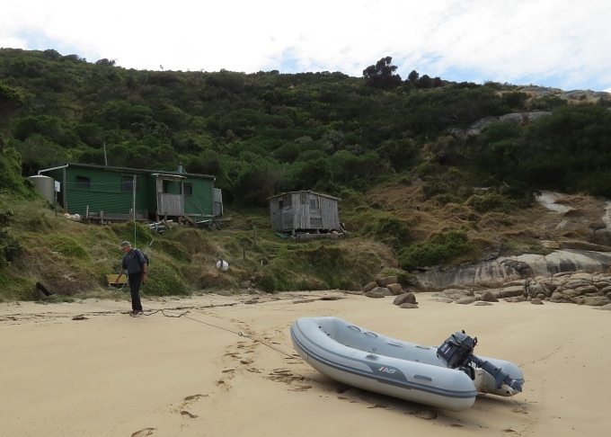
The area close to the hut and the beach at the north end of the bay has claimed several boats over the years including a yacht in 2010. We anchored south in the bay and Cups sat comfortably as we dinghied over to the beach.

In 1958, Jack and Gladys Lierich built a hut on the north end of West Cove on the site of the present hut. The hut was built of driftwood collected on the local beaches and lined with sails. Jack was a cray fisherman and they lived in the hut for four years. He built a 38' fishing vessel on the beach, launched her with help from his friends and according to information in the hut, the Mirrabbooka still sails in the Bass Strait.
In the 1960's, the Murray-Smith family began yearly expeditions to the island and continue the tradition to this day. They're known as the Erith Mob and have continued to maintain and make improvements to the hut over the years while preserving the integrity of the island. When they're not in residence, the hut is open to visitors and campers. We wandered through the hut. It's very rustic with rudimentary furniture and amenities, but probably quite a welcome respite for kayakers and campers ...and the family who was shipwrecked here in 2010.


The Erith mob have also cut and maintained tracks across the island. We followed several which meandered up the hill from the beach through bush and forest. There are no wallabies here, but there were certainly a lot of birds. Cape Barren geese shared the track with us for a ways, honking their concern at our presence. Firetails, flame robins, pippits and a brown falcon topped our list of bird sightings. We saw no snakes, but the native skinks were plentiful.

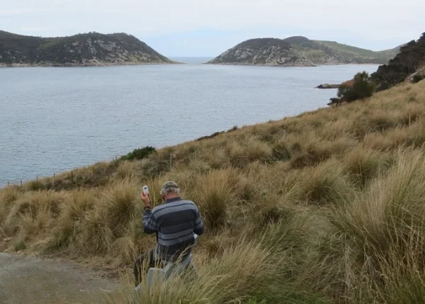
We climbed to a notch between two large hills and were rewarded with a spectacular view of both the Murray Channel and the Deal Island Lighthouse on one side and the Bass Strait on the other. Wilson's Promontory, some 60 miles away, was a faint shadow on the horizon. The key interest in this particular location? An internet connection … three bars worth! David sat on the hillside with the Telstra dongle and the i-Pad reading emails and checking weather forecasts.
This sidetrip was enjoyable, but as the wind picked up, we hustled back down the track to the beach, launched the dink and headed back to Cups. The channel roiled with the wind and current, but once back to our East Cove anchorage, all calmed down. We settled into the anchorage, waiting for that elusive weather window. It's always just a couple of days away.
King Island
40S03.88 / 141E03.78
Grassy Harbour Port is located behind a man-made breakwater and we were fortunate to be able to pick up a local's mooring for use while we were here. Another Dutch-flagged cruising yacht was already at anchor in the little harbor and a small ship was at the dock, loading prime King Island cattle aboard. The breakwater, we later learned, was made of tailings and rubble from an open pit scheelite mine that was active until 1990 and now closed. The breakwater is also the best vantage point for watching a colony of fairy penguins return to their nests at dusk.
We got a lift to the little village of Grassy about 5 km away from the harbor. It's pleasant, but it's not much...a very small grocery, a couple of limited-hour restaurants, the Kelp Craft store (yes, kelp craft...more on that later), a laundromat. You know it's a small town when you see an ad on the bulletin board that offers “Number Cake Tins (0-9) for rent...$10 for 48 hours” and another offer to sell you “sticks for your stove – just call my mum for more info” with no name or phone number.
The “big smoke” on King Island is Currie on the west side of the island, some 30 km away. We were way under budget for expenses in January and thought we'd splurge on a car rental here for a couple of days in order to see the island. Part of the plan, right? Sail to places and then get off the boat and see what's there.

Back to the Kelp Craft, for a minute. When we envisioned “kelp craft”, or anything to do with kelp actually, we thought of the huge wads of thick, heavy brown weed that we pulled up on the chain and anchor in Patagonia. We had to use a machete to hack it off and it took forever. What “craft” could you fashion from these sea weeds? Well, Betty and Bevin have figured it out and the results are pretty outstanding. We were so impressed with their artwork that we bought a kelp seahorse. I mean when your art medium is kelp, you've got to be congratulated for your imaginative efforts, don't you think?
We walked back to Grassy Harbour along a gravel road that led past the scheelite mine and then to Sandblow Point. We saw wallabies, a rather large blue-tongued lizard crossing the road and lots of birds. We were especially warned about the venomous snakes here … tigers and copperheads … it's mating season and they're all a bit cranky. We didn't see any though (and I was just as glad). The walk back along the white sand beach was invigorating with the sand blowing (hmmm...Sandblow Point) and the waves licking our toes.

We picked up the car the next morning and decided to explore Currie first since we had to complete our rental paperwork there. It's not as small as Grassy, but it's not very big. Let's put it this way... there are no traffic lights on King Island and the only traffic circle (rotary) is in Currie. We saw the lighthouse (not impressive in our humble opinions), the museum was closed; visited the harbour (very impressive, especially the entrance with huge rollers impeding the entry...wow!) and the cemetery (lots of room for expansion). We picked up stuff for a picnic lunch at the Foodworks supermarket and then headed south.

First stop, the kelp processing factory. Now here's an interesting product to market (beyond the kelp craft previously described). How could we have ever known that durvillaea potatorum aka bull kelp could be of such importance to the biopolymer industry, but it is. We learned all about it, then found a beach where a fellow was harvesting kelp. Pretty interesting stuff.

We drove to Stokes Point at the southern tip of the island on a winding, narrow, gravel road. Not quite like four-wheeling, but close. The views were great; the lighthouse, not so much.

We noted lots of cows en route grazing on kelp … they must like the salt. There are lots and lots of cows on King Island. Not as many cows as wallabies though which they estimate to be 3X the human population of ~1700.
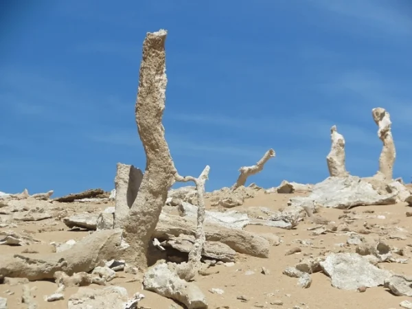
The Calcified Forest was actually a surprise. Tree roots calcified over time and when the root died and rotted out, only hollow shells remained … a small forest of them.

The Cataraqui Memorial Walk was a sad reminder of the reason King Island's lighthouses were originally constructed. The entire coastline of King Island is dotted with shipwrecks, in fact more shipwrecks than any other part of Australia. There's a Shipwreck Trail to follow with memorials near the sites of the most disastrous ones. The Cataraqui which went down in 1845, is still the worst civil maritime disaster in Australia's history with a loss of 400 lives. A memorial marks the site of the mass grave.

We were home just before dark, scampering down the rocks to recoup the dinghy which was moored a ways offshore to account for the sizable tides here (~2m /6').

We had high hopes for the day. A morning shower dampened us a bit as we motored ashore in the dinghy, but resulted in a rainbow over the bay. Then we saw the flat tire on the rental car.


King Island was once quite forested, but milling, clearing and fires have rendered it mostly grassy, rolling hills now that stretch from sea to sea, good for farming and pastureland. Only a few main roads on the island are paved, the rest are gravel or hard packed dirt. Wallabies jump out of the bush at you frequently. Wild North American turkeys comb the fields for breakfast and peafowl and ring-necked pheasants roam quite freely. We probably saw more raptors (kestrels, harriers and falcons) than any other type of bird, except maybe pied magpies and ravens. An abundance of roadkill provides food for scavengers all up and down the food chain.

We headed first to Penny's Lagoon in the Martha Lavinia Nature Reserve. This is place noted for observing a wide array of native birds, but we saw very few . Perhaps we were too late in the day with our flat tire delay. We did the circuit walk and did see two large tiger snakes in the bush which gave me an adrenaline rush. We think it was coitus interruptus because they scurried off, each in their own direction, embarrassed by our intrusion. We beach combed for a short while on sprawling Lavinia Beach known primarily for its surfing waves. The rollers were huge, but other than two surf casters, the beach was totally deserted … save massive hordes of huge biting flies.

The views of Cape Wickham, with huge rollers crashing on the reefs and rocks below, was stupendous and definitely sobering. Several stone memorials nearby marked the graves of people drowned at sea as well as lighthouse keepers and their families who had died here.

At the northernmost point of the island sits the Cape Wickham Lighthouse. Now, this is a traditional lighthouse, unmanned, but still in operation. It's a beauty. Completed in 1861 and constructed of local granite, it is the tallest lighthouse in Australia and the southern hemisphere. In case you're wondering, the Deal Island Lighthouse is the “highest” light, not the tallest.


We'd sampled King Island cheese while in Tassie and there was no question that we'd stop at their Fromagerie and tasting room along the route. We were allowed to taste nearly a dozen different cheeses. We had little rating sheets to help us make our buying selection at the end. We liked them all though, so we bought a bit of everything. We'll be good on cheeses in the larder for quite some time to come.
Beyond the cheeses, we'd heard wonderful things about King Island beef, but unfortunately, David didn't have the chance to try any. We're always on the lookout for unique items at each place we visit. The kelp industry and art are, of course, unique, but we found more. King Island Cloud Juice is the local gourmet bottled rainwater available in lots of upscale places worldwide. King Island honey is considered quite a delicacy. At the Cultural Center in Currie, we found mutton bird oil for sale for softening leather as well as feral cat skins which I guess can be fashioned into hats, fur collars, etc.
What’s next? We’re back to the mainland and the Discovery Coast in Victoria. Come explore with us.