

GWL – Volcanoes, Vistas and Wildflowers – Lassen Volcanic NP
/Day 35 – Sardine Lake to Lassen Volcanic National Park – 2,906 total miles traveled
We were awakened before 0600 by the sound of an axman chopping wood for his morning campfire. Really … he couldn’t have chopped it last night in anticipation of the morning? Evidently not. Grrr!


We were sorted out, packed up and on the road by 0730. CA-89 is a lovely road, lined with purple lupine in full bloom. This scenic route kind of meanders through little towns, past the limestone cliffs of Soda Creek and along the shores of Lake Almanor. And then, snow-covered Lassen Peak pops into view.

And then Lassen Peak popped into view!

Entering Lassen Volcanic National Park
We entered Lassen Volcanic National Park in late morning. This was another national park we’d never heard of before. Where have they been hiding? It was a gorgeous day with big white puffy clouds in a clear blue sky. We stopped at the Visitor’s Center briefly for a park map and information, but didn’t linger as we were concerned we wouldn’t find a campsite in the limited first come/first serve sites available in the Manzanita Campground. We rushed along the scenic route to the north end of the park with the intention of retracing our route at a much more leisurely pace once our site was confirmed. As it turned out, we need not have worried … there were plenty of spots open and we snagged a good one.

No worries ... there were plenty of open sites available in the Manzanita Campground.
We paid our fees ($13/night) and headed to the nearby Loomis Museum for a look-see, information and video. Benjamin Loomis was the first to capture the 1914/1915 eruptions of Lassen Peak on film and his documenting photography was awesome.


Loomis Museum
There were three easily accessible short trails which gave us a feel for the park and some great views of several peaks. The Lily Pond Trail led us to … you guessed it … a lily pond. The Indian pond lilies were about to burst … our timing was off by a few days.

Indian pond lilies were about to burst open.

Bright red, oddly-shaped snow plants dotted the forest floor as we continued onto the Discovery Trail which circled Reflection Lake.

Despite the wind and ripples on the lake’s surface, the reflection of Lassen Peak on Reflection Lake was awesome.
We continued across the street to the 2-1/2 mile loop around Manzanita Lake. The lake is beautiful and the well-trodden trail hugs the shore with several vista points of Lassen Peak. A few kayakers and anglers were out on the water. Buffleheads, tireless diving ducks, were entertaining and we watched a couple for quite awhile trying to get a photo. They’d surface for a few seconds, then dive down again almost immediately. It was frustrating until we spotted a bufflehead mom with her four ducklings sitting on a log. Obviously exhausted by the trials of motherhood, she sat quietly, tending her kids and catching her breath and some warm rays giving me a chance for a photo at last.

Bufflehead mom and kids
The coniferous forest here is mostly pine and fir … stately trees, 50-60’ tall. Manzanita bushes, for which the campground and lake are named, bloomed profusely. Birds, chipmunks and ground squirrels darted past as we relaxed in our camp chairs and took it all in.

Manzanita, after which the lake and campground are named, was in bloom and all around our campsite.
Day 36 – Curmudgeons and Lassen Scenic Tour
Ah, no wood chopping noise this morning. Instead, we awoke to the pleasant sounds of a concert of RV generators humming loudly. We kind of resent the fact that in some parks (like this one, for instance), we are required to camp with larger RVs because 1) we are technically a recreational vehicle and 2) we sleep in our vehicle. Anyhow, quiet hours are supposed to be from 10PM to 8AM, but apparently this rule does not apply to everyone. By 0700, the place sounded like a machine shop. We understand that some folks prefer larger rigs with power-hungry amenities. The same applied to quiet anchorages when power boats needed to start their generators at all hours. We just dislike the noise and disruption of the peace and quiet. We’re definitely getting to be curmudgeons and cranky old farts, aren’t we? Well, you know what they say … ‘Don’t like the neighborhood? Leave!’ and tomorrow we shall.
Curmudgeon-ry and complaining aside, today was an exploration day. We backtracked as planned along the park’s scenic route, stopping frequently to take interpretive walks and admire interesting sights. Chaos Crags & Chaos Jumbles resulted when the mountain ‘fell’ depositing rocks as deep as 130’ in some areas, damming the Manzanita Creek and forming the lake. Despite the ‘chaos’, this area was one of the few spots in the park where we had any ATT cell coverage.

Chaos Crags & Chaos Jumbles
The Devastated Area was the result of the 1915 eruption which spewed boulders and rocks as much as three miles away. The giant boulder pictured below is lava rock (red dacite) allegedly formed ~27,000 years ago.

That's one big rock!
As we drove to the highest point on Lassen Volcanic National Park Highway (8,512’), the snow was deeper and deeper. We could see where plows had recently edged the snow off the road. My stomach tightened and my chest heaved instinctively reacting to the sheer drop-offs as David negotiated Blue around switchbacks and hairpin turns. I'm really not much for heights.

Sheer drop-offs along the Lassen Volcanic NP Highway
Several of the trails were still snowy and muddy while others, such as the Bumpass Trail were closed for the entire upcoming season for maintenance. We stopped at the Lassen Peak Trailhead … the sign was somewhere under about 8’ of snow!

Somewhere under all this snow is the Lassen Peak Trailhead!
Ice was melting and trickling down in streams and rivulets and small waterfalls as summer approached and higher temps warmed the mountainsides. Lake Helen was a glacial blue and partially melted, but oh so beautiful.

Lake Helen view
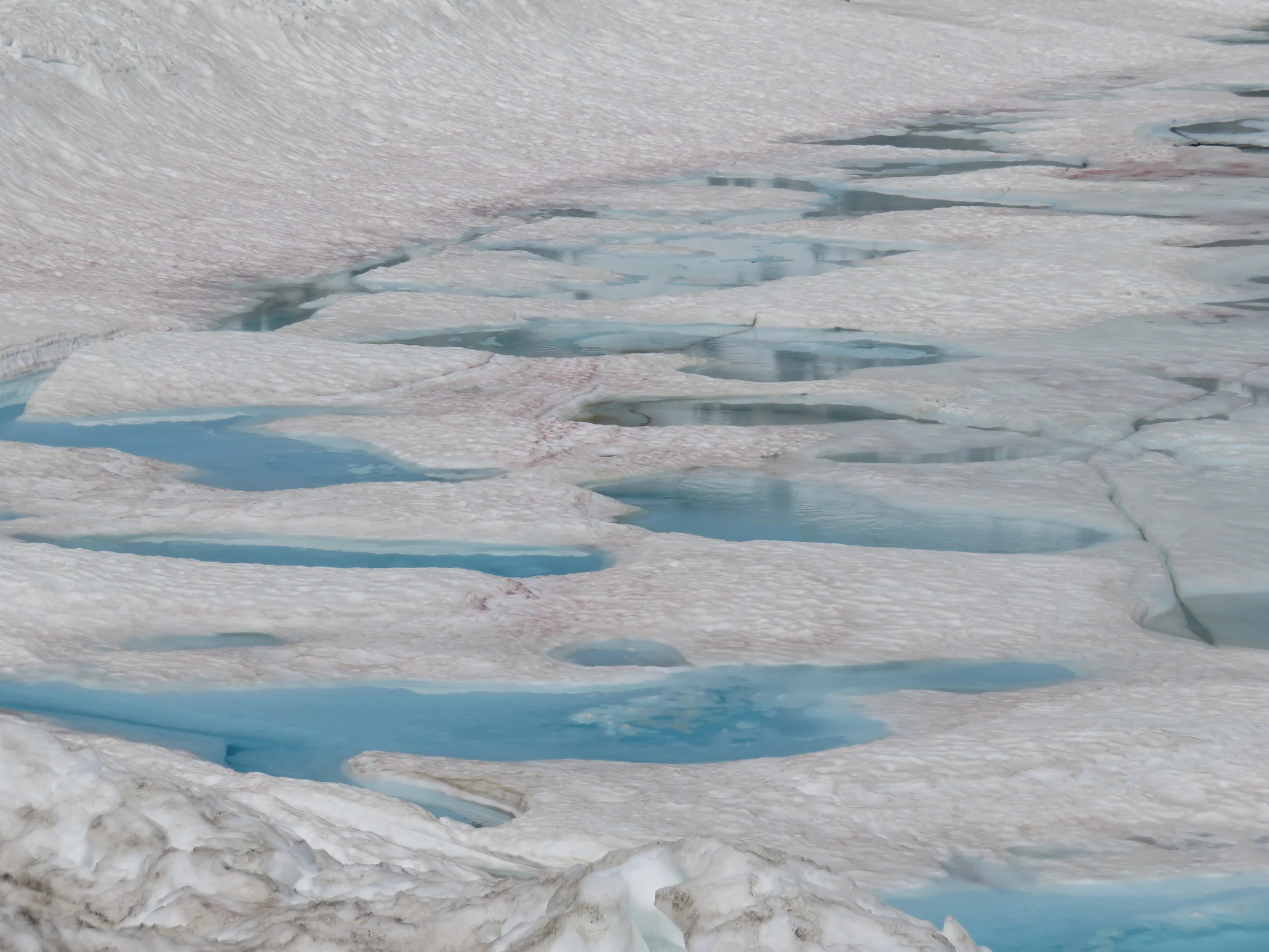
Glacial blue color of melting ice on Lake Helen
At the Sulphur Works, geothermal activity was evident in the boiling mudpots. The acrid smell of sulphur hit us as soon as we got out of the van. As we neared the mudpots, it was harder to breathe … very reminiscent of the sulphur fumes we experienced on the rim of Yasur Volcano on Tanna Island, Vanuatu a few years ago.

Boiling mudpots and hissing fumeroles at the Sulphur Works
At lower elevations, spring flowers were in full bloom. Lupine, Indian paintbrush, alpine forget-me-nots and delicate yellow columbine graced the hillsides and shaded trails.


We hiked the moderate 5-mile Mill Creek Falls Trail, crossing streams, climbing hills, enjoying the wildflowers and admiring the waterfall once we arrived.


By evening, we’d forgotten our morning crankiness and began to savor the evening … that is until the generators started again. We love the national parks and this nomadic life, but we doubt RV parks will ever be the right venue for us.
Lots more to come ... click here to join us as we continue our Great Western Loop adventures.