

12 Tips for Driving the Dalton Highway
/
The 300 mile section of U.S. 50 that crosses through northern Nevada is touted as “America’s Loneliest Highway”, but it must have earned that title before the Dalton Highway was built. We’ve driven both - more than once, in fact, and we can definitely say that Highway 50 ‘ain’t got nothin’ on the Dalton.


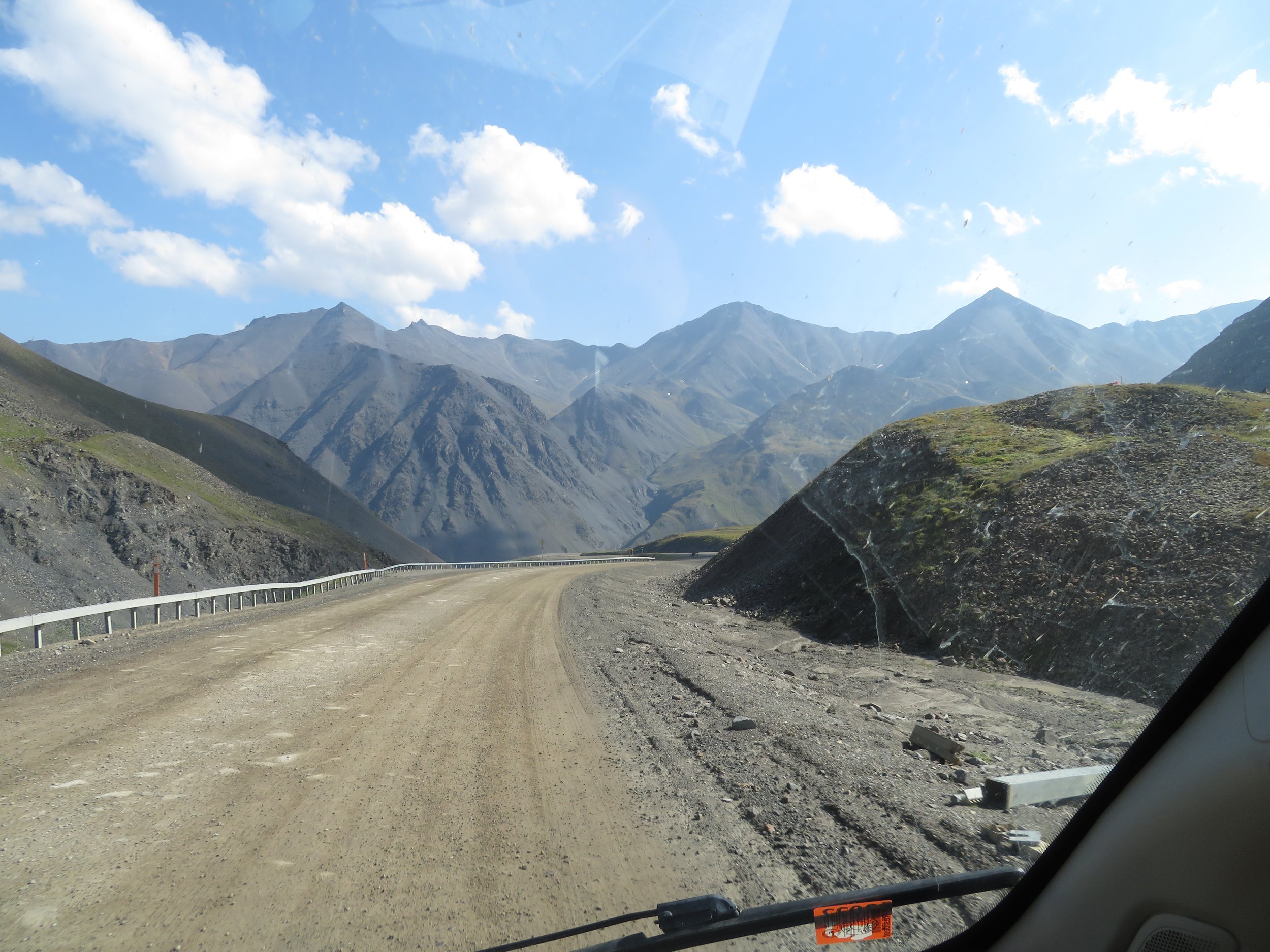
The Dalton Highway, also known as the Haul Road, is 414 miles long and is mostly dirt or gravel - although there are now several paved sections. One of the northernmost roads in the world, it begins at the Elliot Highway, north of Fairbanks, and ends at Deadhorse and the Prudoe Bay oil fields on the Arctic Ocean. There are very few services along the road. In fact, for the last 225 miles, there are no services whatsoever, including very limited cellular service, until you reach Deadhorse.
In 1992, we rented a car and drove as far as the Arctic Circle on the Dalton Highway. It was quite a bit rougher then. We lost a wheel cover and bent a rim, and the car was totally covered in mud and dirt by the time we returned. The rental company was less than pleased with us. This time around, just as in preparation for driving the 575 miles of the Dempster Highway from Dawson City to the Arctic Ocean earlier this year, we did a lot of research before taking on the Dalton Highway a second time. We studied the latest edition of “the bible of North Country travel”, The Milepost. We read the blogs of others who had driven it, as well as information provided by the BLM. As we traveled the road, we talked to drivers we met along the way, including a few truck drivers who routinely drive it, to get their input.
Now that we’ve completed the journey and dipped our toes into the Arctic Ocean once more, we can assure you that it was quite a wonderful adventure. We didn’t make it totally unscathed - we got one ding in the windshield, a couple more on Blanche’s nose, and it took $20 worth of coins to get her clean again once we got back to Fairbanks, but all-in-all, pretty minor stuff, compared to the fantastic scenery and awesome wildlife we saw.
In our estimation, the road is quite doable by almost any passenger vehicle… if the weather and road conditions are good. We saw a Mini Cooper as well as a Model A Ford pulling a small camping trailer make the trip. On the other hand, sudden rainstorms can cause washouts and rock slides; tire destroying potholes and sink holes sometimes seem to grow overnight; and rocks from oncoming vehicles can take out your windshield. You can expect filling- loosening washboard, extremely dusty conditions when it’s dry, slippery, gooey mud when wet, and lots of dangerous curves, steep grades and sharp drop-offs on either side of the road. Knowing what to expect, along with some prudent planning, however, will greatly increase your chances of making the journey without mishap. Here are some tips we think might make the trip a little easier. But first…
A Little History
The Dalton Highway was built in 1974 by a consortium of oil companies to support the construction of the Trans Alaska Pipeline. Amazingly, it took only five months to build the difficult 385 mile stretch between the Yukon River and Deadhorse - that plus $125 million and 3 million man hours. Initially, only construction and supply trucks were allowed on it, but in 1981, the first half was opened to the public as far as mile marker 211, and in 1994, private vehicles were permitted to drive the entire road
The State of Alaska now owns and maintains the road. A lot of tour buses and private vehicles make the trip to the Arctic Circle and back. Beyond there, the majority of the traffic is from pipeline workers and heavy trucks hauling fuel and supplies to the oilfields at Prudoe Bay. Interestingly, even though massive quantities of oil are pumped out of the surrounding oilfields and piped south, it’s apparently less expensive to haul tankers of gasoline and diesel fuel from Fairbanks than to build a small refinery at Prudoe Bay.
En route, we encountered several camper vans and motorcycles that were either beginning or ending their odyssey from Ushuaia, at the southern tip of South America to Prudoe Bay. Even more impressive were the individual bicyclists we met that were starting or completing the same route. Wow!
Here are those tips on making the trip a little easier:
#1. Which Vehicle
As mentioned earlier, just about any passenger vehicle can make the trip if conditions are good. That Mini Cooper had very little ground clearance. On the other hand, if you are driving the Dalton after there’s been significant rain, you are likely to encounter a lot of slippery, boggy, muddy places, and possibly a washout or two, and a higher clearance, AWD vehicle would be more advisable. The road is plowed and kept open during the winter, but studded snows, chains, and/or AWD are required.
If you’re planning to rent a car, be aware that most of the major rental companies in Alaska prohibit you from driving their cars on the Dalton. There are a couple of rental companies in Fairbanks that will rent vehicles for this use, however - typically rugged 4x4 SUVs and pickups.
#2. Preparing
There is no calling AAA here. If you have a problem, it’s quite unlikely that you’ll have cell coverage, and even if you do, the cost of having a tow truck come to the rescue will be very expensive. Even if you have towing insurance, it may not cover you on the Dalton. The number one essential item is one, or preferably two, full size spare tires. We saw several people changing flats. Also make sure, before you need them, that you have a jack and the right tire tools for changing a tire, and it wouldn’t hurt to make a dry run before you depart to sure you can actually loosen the lug nuts, jack the car up and access the spare. We met a couple in a pickup camper who couldn’t use their spare because the mechanism for lowering it was inoperative. They had to hitch a ride 100 miles to Coldfoot with the flat, get it repaired, then hitch a ride back to their truck.
We had a full size spare and also brought a tire repair kit, as well as a small, 18v battery powered tire inflator, and before we left, made sure it would inflate our rear tires to the required 80 psi. In addition, we have a pretty complete toolkit; screwdrivers, hammer, pliers, adjustable wrenches, wire cutters, crimpers, socket set, and a set of box/open end wrenches.
#3: Road Conditions and Speed
The Dalton is about 60% packed dirt, gravel and 40% paved sections. In the unpaved sections, there were many areas of washboard, dips and holes, but road crews are continually grading and repairing the road, and the freshly graded parts were as smooth as a good paved road. On the other hand, the paved sections often had so many frost heaves, sink holes and humongous potholes, we’d find ourselves longing for the unpaved parts. The last fifty miles into Deadhorse is paved, and with the exception of just a couple small patches, was as good as any road in Alaska.

As in all of Alaska, you should expect delays due to road maintenance. You should also expect to encounter a few road graders at work. As they grade a stretch of road, working from one side to the other, they push the dirt towards the center, making a rather intimidating berm as they progress. If you’re lucky and your timing is right, you won’t have to cross the berm, but if not, you may have to choose between following the grader for miles at 15 mph or crossing over the berm to pass. That’s not much of a problem if you have a car with reasonable clearance, but could get you high centered if you’re driving that Mini Cooper.

The posted speed limit is a maximum of 50 mph, and that was a reasonable speed for many parts of the highway. For much of the unpaved sections of the road, however, driving that fast made us feel like our fillings would be shaken out and the van was going to come apart. Conversely, on many of the paved sections, driving that speed meant I had to concentrate on swerving around the next pothole or braking hard to lessen the jolt of a frost heave, and couldn’t enjoy the spectacular scenery or watch for wildlife. We weren’t in a hurry and chose to drive at a slower speed for much of the Dalton, letting other people pass.
BTW, if you’ve never driven on a washboard hardpack road, the ride is not too bad up to about 10-15 mph, then the shaking and vibration gets progressively worse as your speed increases. There is, however, usually a “sweet spot” speed where the ride is noticeably smoother. Driving Blanche, we found the smoothest ride at a speed of 37 to 40 miles an hour. And remember, when driving on a washboard surface, your stopping distance is much longer than on pavement - something to keep in mind before a moose crosses the road in front of you.
#4: GPS and Guides
We have a Garmin GPS mounted on our dash, to which we downloaded the latest maps and updates just before leaving on our trip north. Still, we encountered many places where it was wrong - and sometimes REALLY wrong. For example, the Dalton Highway is pretty easy to follow… you turn right from the Elliot Highway and drive until you reach Deadhorse. At several places, however, our GPS instructed us to leave the highway and take a rather unlikely route along some little used 4x4 road, or even turn onto a non-existent road. In general, we didn’t trust our GPS throughout most of Canada and Alaska, especially if the route it plotted didn’t seem right.
We remember chatting with a tow truck driver a few years ago while traveling through Wyoming. He said that the GPS was the biggest boon for his business ever. He’d lost count of how many rental cars and motor homes he’d towed after their GPS had led them over one of the local 4x4 roads. The mapping accuracy apparently hasn’t improved all that much since.
The Milepost is a mile-by-mile travel planner and guide to the roads of Alaska, Yukon Territory, British Columbia and the Northwest Territory, and is updated annually. It is an invaluable and essential resource for planning and traveling across western Canada and all of Alaska. We spent many an evening reading most of the 656 pages of our 2023 copy, planning our stops for fuel, groceries and camping, and what we could expect to see and do in the upcoming days. Several highlighters were, in fact, used up while marking the places and things of interest ahead of us. The book devotes seventeen, very informative pages to the Dalton Highway. We did, however, find a few minor errors. The Milepost describes one turnout that wasn’t there, and was off by a mile or two on a few others, but still, it was an indispensable guide to the Dalton and every other road and highway in Alaska and western Canada.


#5: Camping and Lodging
There is limited lodging along the Dalton Highway, and all are expensive. It is highly recommended that you make reservations ahead of time.
Coldfoot has rustic rooms at the Inn at Coldfoot Camp. Current pricing: $250
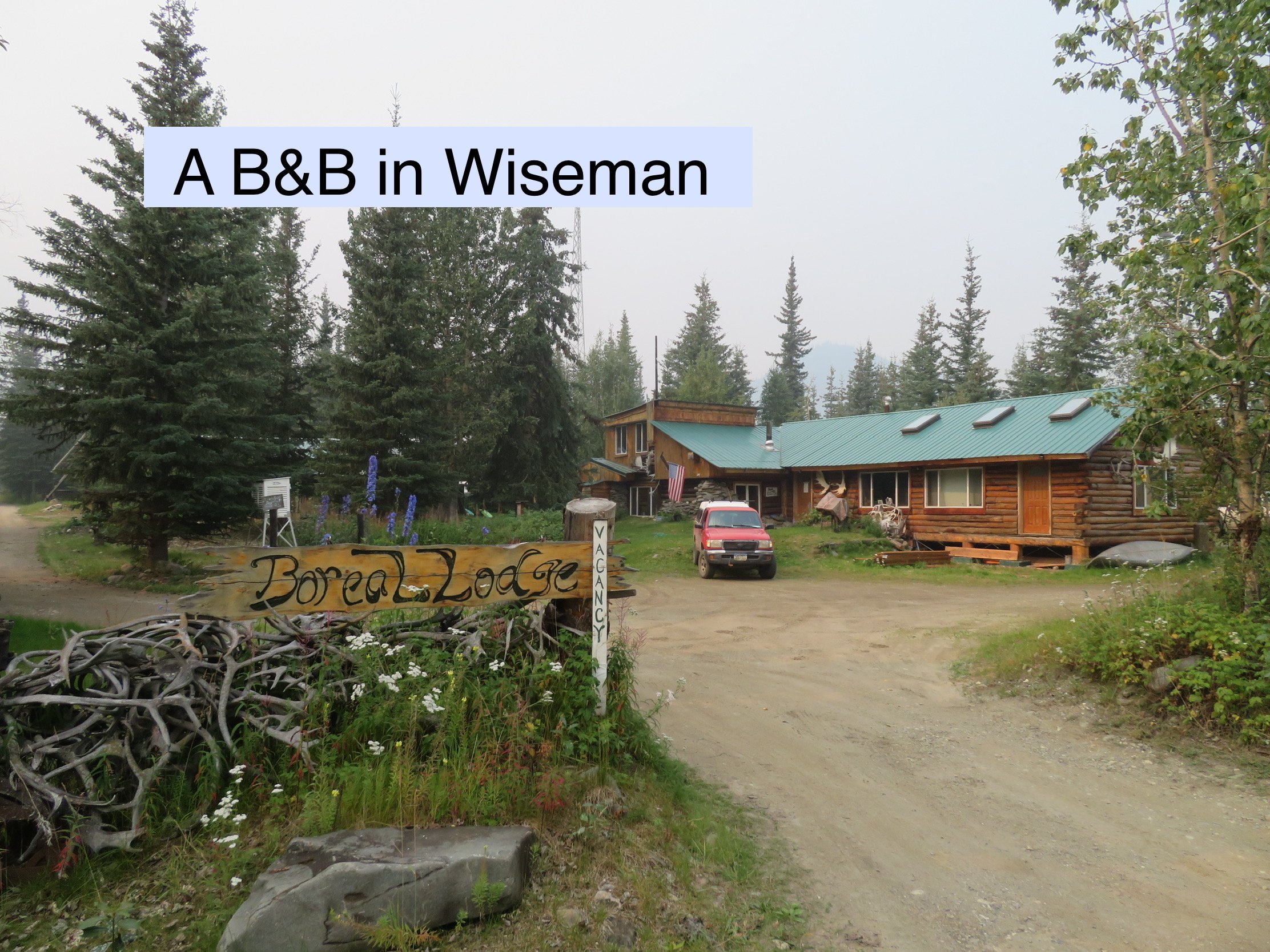
Wiseman, a tiny town a few miles north of Coldfoot has two B&Bs, also in the $250-$300 range.
Deadhorse has three hotels, and it is also possible to get rooms with shared baths at the “camps”, the lodging provided for the oil workers.

There are several campgrounds along the route:

Mile 60.5 - Five Mile campground, an undeveloped BLM campground
Mile 115.5 Arctic Circle BLM campground with picnic tables, fire pits and toilets. No water.
Mile 175 - Coldfoot Camp has RV hookups and tent camping
Mile 179.7 - Marion Creek BLM campground with picnic tables, fire pits, toilets and water. When we were there, the water was available at a hand pump, and while presumably potable, it was very rusty colored. We used it for dishes and dousing the campfire. The campground host is the furthest north public campground host in America. We also had two bars on our AT&T cell; no bars on Verizon, however.
Mile 274.7 - Galbraith BLM campground with picnic tables, fire pits and toilets. No water. This campground is about 5 miles off the road on a gravel road.
In addition, there are probably a hundred turnoffs and pullouts along the road that you can stop for the night, some with toilets. If there are no signs prohibiting overnight parking, you are free to do so. There are no campgrounds in Deadhorse, but we found a nice pullout at mile 411.5, just outside of town that was off the road and alongside a small lake. No toilet or water.
#6: Fuel

The first half of the road has a tiny truck stop at the Yukon River Bridge, mile 56, that may, or may not have fuel. Coldfoot, the world’s most northern truck stop at mile 175, has both gas and diesel. It was the most expensive gasoline we’ve ever bought - $7.50 a gallon in the summer of 2023.
The only other fuel stop is at Deadhorse at mile 414. It was slightly cheaper at only $7.39 a gallon.
The Dalton Highway is not EV friendly - we saw nary an EV charging station once we left Fairbanks. There were 120vac, 15amp electrical outlets available in Deadhorse, however, so if your vehicle had a range of at least 500 miles and you are patient enough to wait the couple of days necessary to recharge at 15 amps in Deadhorse, it could be done.

#7 Dust and Rocks
After driving the Dempster Highway to Inuvik in northern Canada, we anticipated a lot of dust. There, fine brown dust and grit permeated and penetrated every possible surface and object inside and outside our van. It came as quite an unpleasant surprise when, after the first 250 miles or so of gravel and dirt road, we climbed into the back of Blanche to find our pillows, blankets and everything else covered in thick dust. No one was immune, either. Other folks we talked to, whether in an RV, van or pickup camper all complained about the dust coating everything.
After that first day, we used a tarp to cover our bed and pillows, and stowed everything else that we could inside drawers or our mule bags. Dust still found its way into the drawers, but not in the same quantities as on the exposed shelves and counters.
On the Dalton, dust didn’t seem to be as much a problem. We encountered several water trucks wetting down the road, which helped immensely, and the weather was also damp and foggy for the northern portion, which also reduced the dust. At a different, dryer time, dust might very well still be a problem.
Flying rocks were a problem on both roads. There are a lot of big trucks using the Dalton, but surprisingly, they weren’t much of a problem. They all stayed well on their side of the road and all had mud flaps that prevented rocks from being flung. We were hit much more often by rocks thrown by passenger cars and pickups.
In general, we found that if we slowed to 25-30 mph and moved as far to the right as possible when passing an oncoming vehicle, we’d still get hit, but not as frequently, and the rocks that did hit us were lower in velocity and less likely to ding our windshield. Be careful when moving close to the edge - much of the road is elevated to protect the permafrost, with very narrow shoulders and sharp drop-offs. Rollovers are a common occurrence.

#8: Cell Coverage and Internet
Cell coverage was pretty limited. We have two phones, one that uses AT&T and one that uses Verizon. Once we left Fairbanks, we had no coverage on Verizon for the entire trip. We did have coverage on AT&T at Marion Creek campground, Galbraith campground, Coldfoot, and Deadhorse.
We saw no internet access, free or otherwise, anywhere.
We did see a few campers using Starlink, the satellite internet system. Those we talked with were happy with the system. The only issue seemed to be that, since there are far fewer satellites in low-earth orbit over the far northern skies, the Starlink antenna needs an open sky, i.e., not a lot of trees overhead, to make and maintain an acceptable connection.
#9: Groceries
The truck stops at the Yukon River and Coldfoot, and the Napa Auto Parts/Ace Hardware in Deadhorse, sell chips and snacks. Other than that, there are no grocery stores along the entire route. Some alcohol is available at the bar in Coldfoot, but no alcohol can be sold in Deadhorse.
#10: Courtesy and safety
Some pointers regarding road safety and courtesy:
As mentioned before, when approaching an oncoming vehicle, slow down a little and keep as far to the right as you can to avoid getting hit with rock… or hitting the other vehicle with one.
Despite what we read about the huge trucks hurtling past at 60 mph, throwing rocks through our windshield, we found most of them to be courteous and careful, usually slowing down as they approached. Whether they did or didn’t slow down, we did the same as for any vehicle (see above).
If someone wants to pass you, as soon as you can see enough of the road ahead to know it’s safe to do so, put on your right turn signal, slow a little and keep to the right until the vehicle passes you. Remain at the slower speed until the dust settles so you don’t have to eat their dust any longer than necessary.
If someone lets you pass, turn on your flashers for a couple of seconds to say thanks.
#11: Water
Water was scarce. If you are camping, be aware that most of the campgrounds don’t have potable water. Drinking water is available for sale at Coldfoot and Deadhorse.
#12: Dipping Your Toes in the Arctic
Unlike the Dempster Highway in Canada, you can’t drive all the way to the Arctic Ocean. The road ends about eight miles from the water and access is blocked by the high-security Prudoe Bay oilfields. You can book a seat on a shuttle bus that will take you the rest of the way, however, at Deadhorse Camp. The trip is narrated, and includes enough time to go for a swim in the Arctic if you’re hardy enough. The cost was $68, towels included. Several of our group, including the driver actually did go for a dip. We would have stripped to our skivvies and jumped into the 40° F water ourselves, but then remembered that we were camping and had no way to wash the salt off. Just kidding - we thought it enough of a challenge to roll up our pant legs and wade out up to our knees.

Reservations for the shuttle must be made at least 24 hours in advance, and either a passport or driver’s license is required.
If you decide to go, we hope you enjoy the journey as much as we did. If you’d rather take a virtual trip, you can travel with us via Marcie’s blogs here.
