

Land Ho - Rodrigues Island
/We did, indeed, heave-to about 20 miles northeast of Rodrigues. We stowed the whisker pole and tidied up a bit below. We enjoyed the rest of our dorado catch in a citrus marinade for dinner. It was a beautiful night ... light winds, small seas, and a gazillion stars, so not at all unpleasant. We maintained a watch, but it was easy duty, just floating lazily, quietly and peacefully. We drifted about three miles in the right direction during the night, and after a batch of chocolate muffins came out of the oven, we adjusted the sails and headed into Port Mathurin, the entry port for Rodrigues. I dug out the courtesy and Q-flags and David ran them up the halyard. He found a tiny flying fish on the aft deck.

mauritius flag
We'd had a few brief showers during the night and a heavy gray cloud still shrouded Rodrigues Island. From this distance, the island resembled a speed bump in the middle of the ocean, placed there to slow us down.
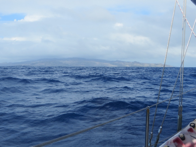
gray cloud over rodrigues
We took turns showering and dressing appropriately in anticipation of meeting several officials in the upcoming hours. We contacted Rodrigues Port Control about two hours out and received permission to enter the harbor. We'd heard another boat announce its arrival just before we set sail, so we wouldn't be the only new kids in town.
As we approached about 3 miles offshore, the island features began to take shape. Mangroves fringed the shore. Further up the hillside, a copse of trees contrasted sharply with large areas of tawny brown. The highest ridge of the island succumbed to black volcanic rock. We could see a small town close to the water, houses clustered close together, and several houses dotted the hills sporadically. A red and white tower sat upon the hill and wind turbines were busy churning out power for the islander.

island features
The island is surrounded with reefs. We aligned Cups with the leading marks to enter the outer harbor, then caught sight of the red/green markers delineating the channel. The water changed color rapidly from dark blue to turquoise as we lost depth. We spotted masts, but had to maneuver through the coral ...a dogleg to the left and then to the right, before we reached the inner harbor.

red green markers
The supply ship/ferry was docked and the harbor seemed quite small. Six boats were already at anchor and finding a good spot out of the channel took a couple of tries. Before we had even set the anchor, a dinghy of officials was hovering around us waiting to board. Rodrigues at last.

officials en route to cups
Passage stats:
Total miles planned: 1985 Total miles sailed: 2036
Passage days: 13.5 Average speed: 6.3 knots
Flying fish: 26 Squid: 1 Birds: 1 booby Fish caught: 1 dorado