

Great Australian Bight - Crossing Plans
/
Wiki defines the Great Australian Bight as “a large bight, or open bay, off the central and western portions of the southern coastline of Australia”. The coastline of the Bight is characterised by 400' (120m) cliff faces known as the Bunda Cliffs, said to be the longest line of seacliffs in the world . The International Hydrographic Organization considers the Bight part of the southeastern Indian Ocean, but on all Australian charts and maps, it's the Southern Ocean. It's a 600 nm stretch of tough ocean passage marked by submarine “terraces” and “canyons” with depths ranging from ~16,000' (5000m) to 164' (50m) causing those southwest swells that prevail to become big rollers.
The Great Australian Bight (GAB) was first noted by European explorers in 1627, when Francois Thijssen, a Dutch navigator sailed along its western margins. Our old buddy, Matthew Flinders, British navigator and cartographer was later the first to accurately chart the area in 1802, during his circumnavigation of the continent. The GAB runs east to west in alignment with the equator and is the longest ice-free coastline running in this direction in the Southern Hemisphere.
Few cruisers transit the Bight for obvious reasons. There's a certain amount of trepidation associated with that part of the world. The charting isn't up-to-date and in many areas, “inadequately surveyed” shows up as a comment on even our electronic charts. We've known, however, several people who have crossed without incident and met fishermen who made their living in the area.
Originally we thought we'd do as most others do … wait for a weather window and just get across. After chatting with Warrick on “Olein”who fished the area for many years and recommended seeing some of the Bight, we started to think about things a little differently. Though we're keen to get across safely, we've never been known to hurry, so we looked into the possibilities.
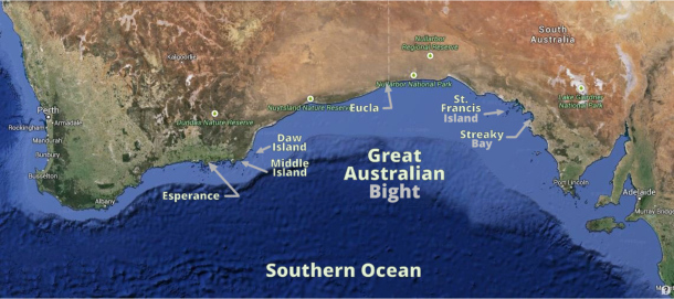
Warrick gave us his copy of Western Australia Cruising in exchange for some Tassie guides we had. Additionally, he provided several hand charts he used as a fisherman. We also have Jack and Jude's (Banyandah) South and Western Australia anchorage guides/information. Then, of course, we talked to Geoff here in Streaky Bay who highly recommended a stop at St. Francis Island. So instead of streaking across the Bight, we're now considering a more scenic route.
- Streaky Bay to St. Francis Island
- St. Francis to Eucla
- Eucla to Daw Island (Eastern Group)
- Daw to Middle Island
- Middle Island to Esperance (next port of call)
Keep in mind though, we've never stuck to a plan yet.
What's to see? Well, it's a gathering place for Southern Right Whales in winter although we're a bit too early for that. Blue whales, humpbacks and sperm whales also travel through the Bight. There are Great Whites, dolphins, sea lions, southern bluefin tuna, squid, octopus and lots of seabirds. In fact, the Great Australian Bight has some of the highest levels of marine diversity and endemism (occurring nowhere else in the world) in Australia. Stopping at little deserted islands will be an interesting adventure. Most islands are known to have a healthy snake population, so we'll be wearing our boots.
During our travels, internet may be non-existent. We'll be emailing Gentry our blogs for posting, but we'll have to catch up on the photos later. Wish us luck!