

The Blue View - Finding the Gulf Stream
/ We are very conservative sailors. We reef down before we need to when we see potentially bad weather approaching or in the evenings when we can't always see a squall coming our way until it is on top of us. Likewise, we use less sail than we did a few years ago - we'd rather trade a few miles of distance each day for a more comfortable ride. We call it 'leisurely sailing' (although in our younger years we undoubtedly called it 'old fart sailing'). A good day for us now is 150 nautical miles, just over an average of six knots.
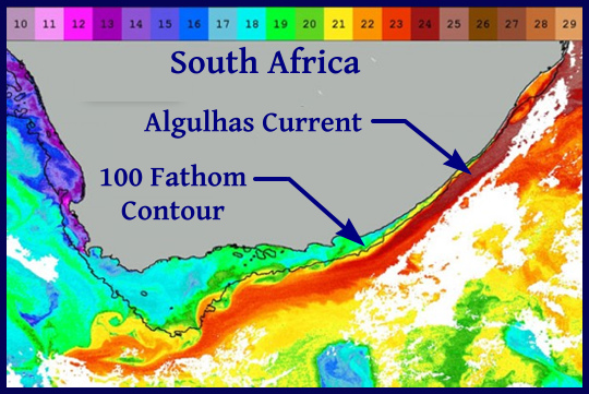
That said, we are certainly not opposed to going out of our way a bit to find a friendly current or avoiding an adverse one. We had a fast passage from Brisbane to Sydney Australia one year by taking a free ride on the the East Australia Current. Our only 200+ nm day was thanks to the extra 3+ knots that we picked up from the Agulhas Current off South Africa. On the other hand, we tried our best to avoid as much of the Humboldt current as we could, as it was against us for most of our trip down the west coast of South America.
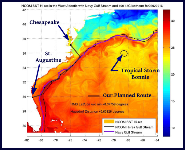
Now as we head up the east coast of the U.S., we are hoping to add 50-75 nm to our daily passages by taking advantage of the mighty Gulf Stream, just as mariners for the past 400 years have done. Its location is fairly constant along the south Florida coast, but the course it follows varies as it travels further north. For the modern day sailor, however, locating the Gulf Stream is much easier than it was even thirty years ago.
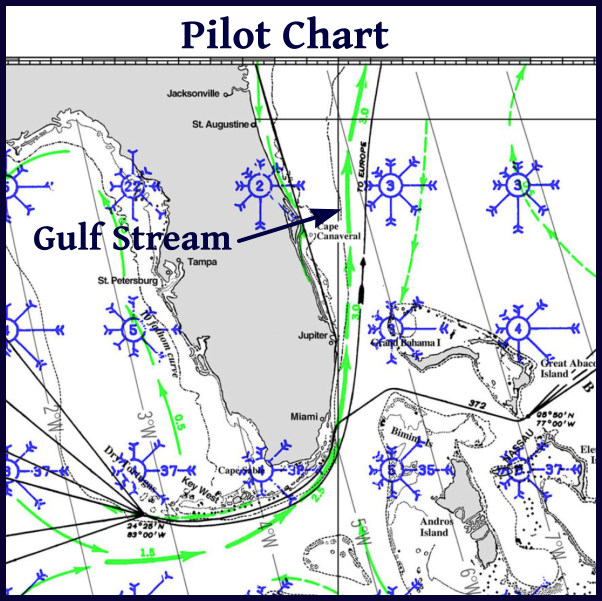
A hundred and fifty years ago, mariners would use Maury's Pilot charts and the captain's acquired knowledge to follow the most likely course of the Gulf Stream. By taking periodic sun and star sights using a sextant, the navigator would compare the distance made good to the dead reckoning position and get an idea of how much current was present. In the twentieth century, but before GPSs and satellite imaging, the offshore sailor would head eastward to the 100 fathom depth contour. He would then set a course to follow a few miles east of this contour. (This is the edge of the continental shelf, where the depths quickly drop from a few hundred feet to several thousand feet. (Interestingly, the Agulhas Current follows a similar depth profile off the South African coast.) He might also measure the water temperature to adjust his course, as the temperature of the water in the Gulf Stream is several degrees higher than the surrounding water.
These days, locating the Gulf Stream is quite straightforward. There are daily updates of the thermal satellite images of the Atlantic coastal waters. By going online prior to our departure, I can download the latest images showing the precise location of the Gulf Stream. I use these images to plot a series of waypoints on our chartplotter that will get us to and follow the current. Once we are in the Gulf Stream, we can measure the strength of the current by comparing our 'Speed Over Ground' as measured by our GPS to our 'Speed Through the Water' as measured by the speed transducer on the hull. The difference between the two is the speed of the current.
Technology is wonderful. No doubt, in another thirty years, on-board computers will monitor weather conditions and adjust the sails to maximize our velocity made good, smart radar sets and AISs will monitor other vessels and automatically avoid collisions, and satellite imagery will plan the fastest route. I'll opt for a system that includes a setting that adjusts the ride - where a setting of 1 is the most comfortable and a setting of 10 is the fastest.
Then all I'll be needed for, assuming we are still around and capable of climbing aboard, is to compile the list of repairs to be done at the next exotic port of call.