Crossing the Indian Ocean - Mauritius to Durban Days 3-5
/Day 3 Miles to go: 1369 nm
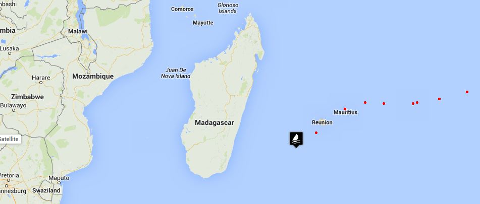
We had originally planned to stop at the French overseas territory of Reunion Island only 120 nm from Mauritius. We'd heard good and bad about it. The marina in Le Port was in an industrial area and a rental car was necessary to get anywhere. The marina at St. Pierre was in a great downtown location, but the entrance could be difficult and the port was closed in bad weather, making a speedy departure a challenge. In the end, Neptune made the decision for us. We were delayed in Mauritius long enough to make a reasonable stay in Reunion imprudent, given the imminent onset of cyclone season. A day for check-in and getting settled, a day to check-out and no time to see the island in between.
We weren't feeling all that good as we sailed past Reunion, so changing our plans wasn't in the cards. La Reunion is a high, volcanic, mountainous island and yet from only four miles out, all we could see was the hazy outline of a land mass shrouded in heavy, grey clouds and mist ... not much more than a blurry smudge on the horizon. It looked as of the French were deliberately trying to hide it from us. No matter, we gave it short shrift and passed on by. When darkness approached, the island was more prominent, its ghostly loom illuminating the night sky for miles and miles behind us.
We're seeing lots of ships during our watches ... several heading to Durban , just like us. So far, none have come all that close and for that we are thankful. Also, thankful to be among the living again.
Day 4 Miles to go: 1226 nm
We rigged the pole yesterday afternoon when the wind backed to the east. By nightfall, it had clocked south/southeast again and we were beam-reaching again. Errant clouds have been sprinkling on us, but for the most part, we're enjoying sunny weather by day and clear skies at night. We're in the midst of a huge high pressure area at the moment, but the GRIBs are showing a low pressure making its way east. We're giving the south coast of Madagascar a wide berth, nearly 150 miles. Its southern coast is known for huge freak waves which we'd prefer to avoid.
We had been doing fairly well distance-wise each day, but we've slowed down a bit. Otherwise, all is well and we're pretty much in the watch groove now.
Day 5 Miles to go: 1129 nm
Though it felt like we were making reasonable speed with the 12 knots of wind we had at our disposal, the GPS showed us going slower and slower as the night progressed. We switched the pole to the port side again around dusk, preparing for the winds to switch to the north. By 0300, we were limping along under 3 knots and by the 10am log, we'd sailed under 100 miles for the 24-hour period. What's up?
It could only be a couple of things. There was enough wind and we had all the sails out and trimmed, so that wasn't it. We could be dragging something ... part of a jetliner, or a whale, or maybe a container, or a longline net with a fishing boat attached? Without actually checking the hull and rudder, the best we could do was hang over the side and stern to see if we could see something. There was nothing apparent.
We thought initially it might be current, but in checking the Indian Ocean pilot for currents in the area in November and December, if there was any current at all, it should have been helping us. David had removed the speed transducer when we got to Port Louis because the marina was so foul and had forgotten to replace it when we left. Since it was the only thing we could think to do short of heaving-to and going overboard to check Cups' bottom, he re-installed it and ..mystery solved. An adverse current of nearly 2 knots had been impeding our progress for over 15 hours.
We switched the pole once again and headed due west with hopes of evading the current. Sure enough, within a couple of hours the GPS speed and the speed through the water were in sync. There's still a good chance we'll make it to Durban by Thanksgiving. No more delays, please!


