The Blue View - Where is Daw Island?
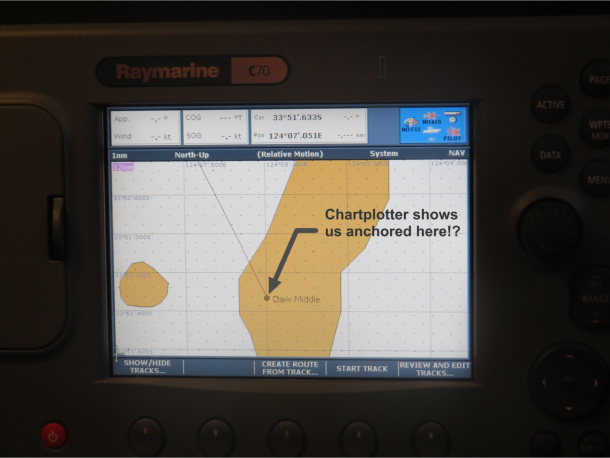
/It is difficult to pin down the exact location of Daw Island, our destination on the west end of the Great Australian Bight. Our Australian paper charts give its position as 33S51, 124E04. Our Raymarine chartplotter gives the position of the anchorage as 33S50.55, 124E08.35, about 3.75 nautical miles further east. We use Navionics Gold software on the chartplotter, but also have Navionics on our iPad. Even the Navionics software on the two devices differed. The satellite view provided by Google Earth gives the position of the anchorage as 33S50.55, 124E08.04, about 0.25 nm west of the chartplotter location. So where the heck is it anyway? Which position do we use? Take the average?
Modern GPS based electronics will locate you on the earth's surface to within a few feet. This accuracy is astounding, and it becomes very easy to rely on those electronic marvels almost exclusively. Therein lies a danger.
Many of the nautical charts, both electronic and paper, are based on surveys that were done before the advent of the GPS. The GPS may locate you on the earth's surface to within a few feet, but the chart may be off by as much as half a mile or more. Thus, the chartplotter may show you being well clear of an offlying danger, for example, when in actuality you may be about to hit it. Conversely, there have been any number of times our chartplotter showed Nine of Cups being high and dry in the middle of an island when we were safely anchored in 50 feet of water a fair distance off the beach.
Fortunately, Daw Island is easy to find in the daylight. It is by far the tallest and largest island in the immediate area. We used the chart plotter to get us to the general vicinity, made sure we arrived in the daytime, then used a combination of the paper charts, electronic charts and our eyes once we could see the island. The shoals and rocks lying off its west and north ends were easy to spot, so it was relatively straightforward to find our way into the anchorage without running into any hard spots along the way.
So which position was correct? This time it was Google Earth. This isn't always the case, however. You would think that a satellite photo would be right on, but we have been in a number of places that Google Earth was also off by a significant amount, along with the chartplotter and paper charts, and all by differing amounts.
The speed at which navigation technology is evolving makes me think that all these issues are short term. A decade from now, we will all undoubtedly have 3-D systems that will safely navigate our vessels for us, between any two points in any of the oceans of the world. Until then, however, I don't think we will be relying entirely on our GPS and chartplotter to find the next anchorage for us, no matter how much it thinks it knows where it is.


