Planning our Indian Ocean Passage
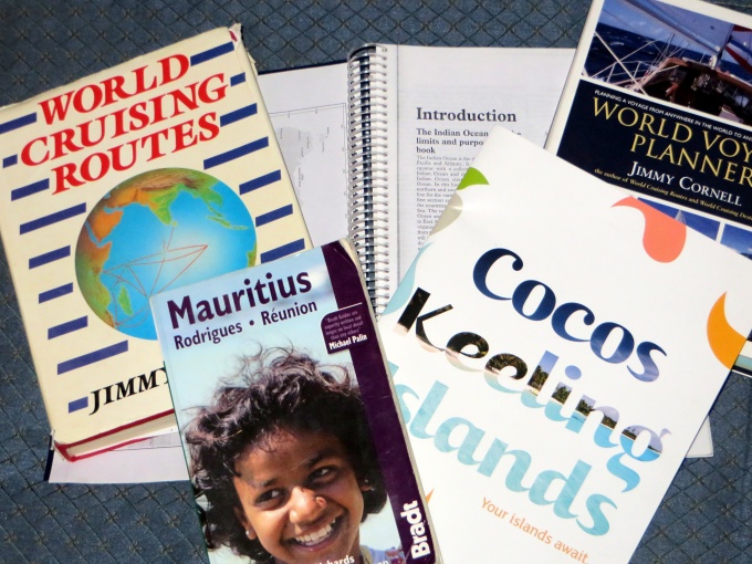
Several people have asked what resources we use for making a long passage, in particular, our 6,100 nm across the Indian Ocean. There are several sources for good information. We usually start by looking at Jimmy Cornell's World Cruising Routes. This book summarizes traditional cruising routes and provides the best time to make the transits based on prevailing winds, currents and weather, a little info of what to expect on the passage, what paper charts are applicable and diagrams of the routes. For instance, we're looking at Fremantle/Perth, Western Australia to Africa. The advice is to sail from Fremantle northwest to the Cocos Keeling Islands to catch the easterlies and then proceed across the Indian with possible stops at Rodriguez, Mauritius and Reunion before making the east African coast.  

resources


Once we've determined the best time to go, we start researching what's along the route and the distances between them. The distances provide us with an idea of what we'll need for provisions, supplies, fuel, etc. Noonsite is a great on-line resource for what to expect in each country we visit. Just click on the country of interest and there's Customs/Immigration info, marina info and much more including any updated info from recent visitors. We find it invaluable.


noonsite


Having a tentative plan allows us to direct our attention to identifying possible cruising guides and other ancillary, helpful information. For this trip we had picked up a used copy of the Indian Ocean Cruising Guide way back in Ecuador and I dug it out. It might be an old edition, but it'll work for our purposes. I also consulted the SSCA archives of articles posted in the last five years and got several useful tips from fellow cruisers who'd been there. There was an on-line guide by Tony Herrick that we picked up as well. The more info, the better. We'll have lots and lots of time to sort through it.

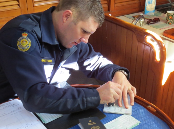
I always try to find yacht arrival information specifically provided by each country. As an example, when I googled “Mauritius yacht arrival”, the Mauritius Revenue Authority website popped up immediately. It confirmed what I already knew about arrival requirements, but getting current information “from the horse's mouth” as it were, is important. Some countries require pre-notification of arrival (like Australia, New Zealand, Fiji) and others prefer that all paperwork is completed before arrival (like South Africa, Australia, New Zealand). I've downloaded all the forms we'll need to complete before arrival.

When we're absolutely sure of the sailing plan, we purchase the electronic charts … two sets. One for the chartplotter (Navionics Gold) and also Navionics charts for the iPad app. We also picked up the small scale paper charts of the Indian Ocean … just in case. While we still have internet, we also collect and save Google Earth satellite views of each harbor and anchorage we will be visiting to augment our digital charts. We had digital pilots aboard already that provide wind roses and currents for easy referral as necessary.


navionics gold


Having a travel guide like Lonely Planet aboard is great for once we've arrived at a port of call. I was fortunate enough to obtain a used copy of the Bradt Mauritius travel guide from another yachtie which also includes Rodrigues and Reunion and I've already begun reading it … like a novel. What's to see? What's to do? What can't be missed?

By the way, I found a great free travel app called Maps With Me for the iPad. It allows you to download any country in the world and provides great detailed maps including the location of supermarkets and ATMs and once downloaded, it can be used offline. It's a gem. I've already downloaded all the places we'll potentially be stopping. Even little Rodrigues Island and Reunion are included.

Don't forget the courtesy flags and the Q-flag! The Australian flag works for Cocos Keeling. I made a new flag for Mauritius/Rodrigues already. Our old French flag will work for Reunion and I dug out the South African courtesy flag from 2007 which will work just fine for our upcoming visit. I put the yellow Q-flag with the other flags we'll be needing all in one zip-loc ready to fly as soon as we arrive.


courtesy flags


There you have it … we're ready to go. Now … make sure the boat is shipshape, the provisioning is done, the fuel's topped up …

Crossing the Indian Ocean - Days 1-3

Indian Ocean Crossing – Update 1

Geraldton, Western Australia to Cocos Keeling

straight shot to cocos keeling

straight shot to cocos keeling

Day 1

Begin: 1423 nm - End of Day1: 1275 nm to go

We were excited and didn't sleep well last night. We had our last minute to-do lists sitting on the saloon table and we were anxious to get them done and head out. Fill the water tanks, empty the trash, take off the sail cover, make the passage soup (Lemay Special) and a batch of muffins, take our last hot showers, do last minute e-mails, pay credit cards … lots to do and actually plenty of time. We finished by 0800 and still had to wait for Customs/Immigration to come clear us out at 0900. We twiddled our thumbs and paced nervously, trying to think of what we had forgotten. We go through this exercise every time we're leaving on a big passage.

Customs arrived right on time and handled all the formalities without a hitch and within an hour we were heading up the North Channel out of Geraldton and doing a slalom around all the lobster traps. The day was brilliantly sunny; the water, an exotic blue-green; the sky, cloudless. What a day to begin a passage.

Once we passed the anchored ships in the outer harbor, we pointed Cups' bow towards Cocos Keeling … a straight shot. We sailed passed the low-lying Abrolhos Islands and sighted whales along the route. Humpbacks were breaching and spouting. I finally got a reasonable shot, but you'll have to wait till we reach internet-land again.

The wind was the predicted 15 knots and we beam-reached for hours. By mid-afternoon, the wind had freshened and the waves had steepened. We took a reef in the main and cruised along in the 7's. By 1700, the wind had worked it way to 25 knots on the beam and we took another reef … and continued in the low 8's.  By 1800, we were both seasick.  We took two hour watches on a cold, raw, boisterous night, fighting off the cold and the seasickness as best we could. The passage soup went untasted.

Even writing this blog on my watch is a trial. More tomorrow.

------------------------------------------ Day 2

Begin: 1275 nm  -  End of Day 2: 1132nm to go

Not much sleep last night, but we're making up for it today with several naps. We're both feeling better. The wind has shifted to SE and we're sailing downwind, wing-on-wing, but slowly in 8 knots of apparent wind. The seas have calmed down and the sun is shining brilliantly. David found a loose screw on the deck while taking his morning walk … always a worry … but we found the stanchion from whence it came and all is good.

A red-tailed tropic bird came a-visiting this morning. A snow white bird, the size of medium gull, these tropical beauties have dark eyes and a single, fire-red tail feather. Females lose their tail feather when nesting and I remember collecting them with Vero, the Cook Islander caretaker at Suwarrow Atoll. My mind wanders.

The sky is pale blue today with puffy, grey-white cumulus clouds floating lazily by. The sea is dark. We saw dolphins earlier, but they were all business and didn't stop by to play.

Despite the lessening of the waves, the swell persists making for a lot of rocking. We've been sleeping like starfish in the aft cabin in our bunk (in shifts, of course). “Starfish sleeping” … laying on our backs, arms and legs spread out to keep from rolling. By evening, the wind returned to 20-25 knots and lasted throughout the night. We gained some good mileage

Sad news from Lin today. Jelly, our ship's cat,  has died. She'd been losing ground and energy for awhile now, and I guess this was her time. I must admit to tears when I read the news. She was, without a doubt, the best pet we've ever had, a good sailor and a good companion.

Magellan Louise Lemay Lynn aka Jelly March 24, 2000 – September 13, 2014

RIP, Jelly! You were loved.

---------------------------------------------------- Day 3

Begin: 1132 nm  -  End of Day 3:  973  nm to go

We had a good run today … 163 miles total and 159 miles to the good (we don't always go directly in a sailboat). I happened to notice the depths on the chartplotter today … 13,123 feet (4,038 m) … yikes, that's deep. Made me wonder what lives down there? Massive, hideous, eyeless creatures? Giant squids with long tentacles that wrap around ships and drag them down? Enough of that …

The days continue to be fair, the night's cold and clear with a waning moon and increased winds. As we move north the temps are becoming warmer during the day … low 70s F (20s C), in the 50sF (low teens C) at night and with 25-30 knot winds, the wind chill keeps us layered up … a t-neck, sweatshirt, fleece and heavy offshore jacket for me, plus sweatpants, socks, scarf, gloves, hat, socks, shoes and two blankets, just about does it for me. It's wonderful to slide into the sea berth at the end of my watch, already pre-warmed by David.

We had to switch the whisker pole from starboard to port side to accommodate a change in wind. This should have taken 15-20 minutes max, but instead it occupied nearly two hours. The pole jammed in the track on the mast and David noticed that the swivel is bent. It took brute force on the part of the captain (read that a hammer), to jury rig it into place, but it'll need attention in Cocos. The list of the to-do's is, of course, beginning to grow daily: a minor issue with the voltage regulator on the alternator, lines to whip, replacing the preventer on the boom. Some we'll do at sea, others will wait. David took a chafed dockline and recycled it into two new snubbers today.

Saw several sooty shearwaters checking out the waters for fish this morning. Perhaps what I read was wrong and we'll have some good fishing in the Indian after all.

Continue of our Indian Ocean Crossing here.

Formalities - Clearing out of Australia

Just like all those forms and formalities you complete when flying into and out of any foreign country, we have to clear in and out of each country we visit, too. The additional issue is that Nine of Cups needs clearance as well. The crew is cleared in and out by Immigration. The boat is cleared in and out by Customs. Depending on the country, there might be a few more officials involved for clearing in. Australia has AQUIS (Quarantine). Other countries have Health Officers, Port Captains … sometime the list is quite extensive. The forms and formalities can be either simple and efficient or tedious, cumbersome and expensive.  

easter island officials


We're pleased to report clearing out of Australia was a breeze. I called the Geraldton Customs Office in advance to ascertain the correct procedure for departure and what exactly it entailed. It was pretty easy. Debra was pleasant and a fount of information. Once I gave her the vessel name, she was able to pull up Nine of Cups on her computer system immediately. She knew that we'd been diligent in completing our quarterly position reports to Customs for the last three years (good on us, huh?) and that we'd last reported in from Mandurah at the beginning of August. She had a picture of the boat on file. She also knew it was about time for us to leave Australia … three years is the maximum time the boat can stay without being imported. She asked that we send an e-mail to give her a couple of days notice for departure clearance and provide the information she needed to complete her side of the paperwork. They would handle the stamping of our passports by Immigration there as well. I can remember trudging from office to office to get heaps of paperwork completed and stamped. This was as good as it gets.


stamping passports


Since arriving in Geraldton, of course, we've had to purchase and install a new windlass. Beaucoup $$$. Australia is gracious enough to refund the GST (10%) paid on large purchases within 60 days of departure. They'll even credit the amount to our credit card! Customs advised they'd be glad to handle this, too. In advance, we were asked to send copies of our passports, as well as a list of electronic equipment with model/manufacturer and serial numbers via e-mail. They'd handle the rest.

So, early on a fine sunny morning, Brett, the Customs Officer, came to the marina and met us aboard Nine of Cups. He completed all the refund paperwork, stamped our passports, gave us our clearance papers and wished us Bon Voyage. No fees involved! Clearing out of a small port with friendly Customs officers definitely has its benefits.


straight shot to cocos keeling


Thank you, Australia! It's been grand. Next stop … Cocos Keeling Islands ... 1423 nm away!