

Crossing the Indian Ocean - Days 4-6
/Indian Ocean Crossing - Update 2
Geraldton, Western Australia to Cocos Keeling
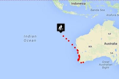
passage map
Day 4 Begin: 973 nm - End of Day 4: 832 nm to go
We're getting on a sched now. Up during most of the day with naps only as needed, eating regular meals and generally enjoying our time at sea. We''re not sure how long the sunny days and fine winds will continue, but we're loving them at the moment.
During our morning deck walk, we found a tiny flying fish in the scupper. He either flew in or got washed aboard, either way there he lay … stranded. He was an itty-bitty guy, no more than 2” (5cm) long, shiny gray and black with gossamer wings, bulging eyes and stiff as a board. Our all-time record for flying fish in one day found in the scuppers was 23 while crossing the Atlantic. They smell awful, so we're not trying to break any records here.
Night watches, though cold, have been beautiful. The stars, especially the Southern Cross, have been brilliant, that is until the moon rises after midnight and steals the show. The moonrise is always a shocker. The sky is totally black and then a loom appears on the eastern horizon and up she pops … dazzling.
The wind switched to SW for awhile today and is now a steady south tending to SSE. Looking at the forecast for the next few days, we're pretty sure we've found the trades … southeast, southeast, southeast.
Day 5Begin: 832 nm - End of Day 5: 686 nm to go
Sunrises tend to be quite dramatic the last few days. The tops of the clouds pink up a little in anticipation of the big arrival. Then an absolutely brilliant sphere of dazzling sun rises midst dark clouds and the contrast is startling. It's an artist's rendition of Christ's rising … no exaggeration. Sharp, golden shards of light pierce the clouds and shine back down to the sea in a Hollywood-esque fashion that only Mother Nature's flair for the dramatic can carry off effortlessly.
Beyond super sunrises, I lost my favorite “Good Old Boat” hat overboard. We were tooling along at 8 knots and turning back to fish it out of the drink was never a consideration.
We are officially in the tropics now … when we crossed the 23.5 latitude line known as the Tropic of Capricorn. We celebrated with an extra TimTam with our cuppas. And today, for our ongoing passage entertainment as I was checking out the sails, I noticed the silhouette of a squid caught in the first reef of the mainsail. He was stubbornly stuck to the sail and we had to sort of peel him off. Look at that … calamari, can't get it fresher!
Day 6Begin: 686 nm - End of Day 6: 566 nm to go
A dark, sapphire blue sea for as far as we can see under a cornflower blue sky … not a cloud in sight. Days have been glorious. We're 600 nm off the Western Australia coast now and Java is about 700 nm due north. We're more than half way to Cocos Keeling and we celebrated with Half Way Alfredo for dinner.
It's a slow sailing day today. The winds are light and a bit contrary. We only made 120 nm to the good. Quite honestly, it's so beautiful out here, who cares?
We're slowly shedding layers … scarf, gloves and foul weather jackets are stowed away and we're down to one blanket on night watch. We're edging our way to the warm, day by day. Reading, writing, making plans, eating, napping and chores occupy most of our days and nights. I still do 95% of the cooking on passages, but David usually does clean-up and dishes which limits our individual time in the galley. Needless to say, long passages have their hidden perks for the first mate.
Another flying fish met his demise in the scupper … this one pretty large comparative to the 2-incher who glided aboard the other night. We regularly see them gliding long distances from wave to wave … must be something chasing them. David put out the fishing lines today.
 . This book summarizes traditional cruising routes and provides the best time to make the transits based on prevailing winds, currents and weather, a little info of what to expect on the passage, what paper charts are applicable and diagrams of the routes. For instance, we're looking at Fremantle/Perth, Western Australia to Africa. The advice is to sail from Fremantle northwest to the Cocos Keeling Islands to catch the easterlies and then proceed across the Indian with possible stops at Rodriguez, Mauritius and Reunion before making the east African coast.
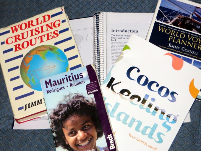

 way back in Ecuador and I dug it out. It might be an old edition, but it'll work for our purposes. I also consulted the SSCA archives of articles posted in the last five years and got several useful tips from fellow cruisers who'd been there. There was an on-line guide by Tony Herrick that we picked up as well. The more info, the better. We'll have lots and lots of time to sort through it.

