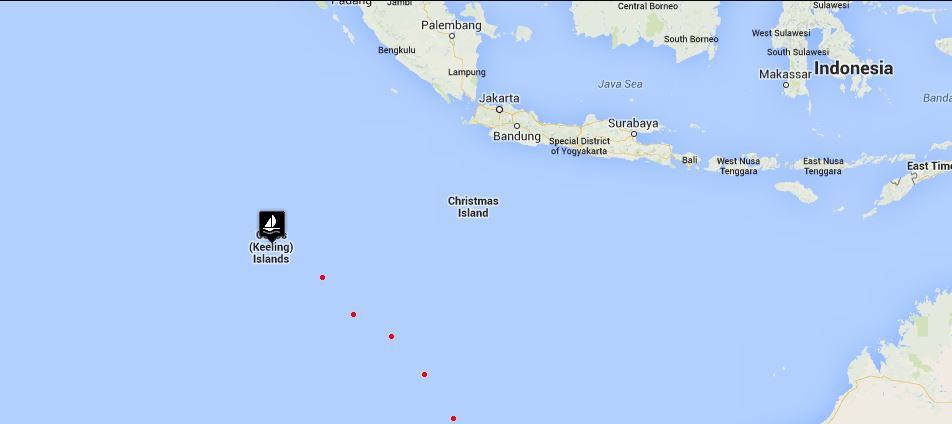
Arrival at Cocos Keeling

62 miles to Cocos and oh, how we worked for those miles. We flew along with just the jib until David noticed a small tear on the leech near the UV. We hauled in the jib, put up the staysail and a triple-reefed main and maintained nearly the same speed. Add a jib repair to the growing list of to-do's. The wind continued to scream with gusts near 40 knots, the following seas building and giving us a sleigh ride of a passage. There were no naps to be had; the cockpit was the most comfortable place aboard. The saloon looked like a hurricane had hit … 10 days of passage including the last two days of rough weather had taken its toll below. A larger Swiss sailboat overtook us and though they didn't respond to radio hails, they waved as they went by. They had a #52 and a rally burgee that we couldn't quite make out flying from their port flag halyard. Hmm … hopefully there's not a rally going to the Cocos. Perhaps, it was a yacht club burgee? Per instructions, we called the Australian Federal Police a couple of hours out to advise them of our arrival. All good, they'd check us in at 2pm tomorrow and we were free to leave the boat prior to that if we wished.

sailboat passing us

sailboat passing us

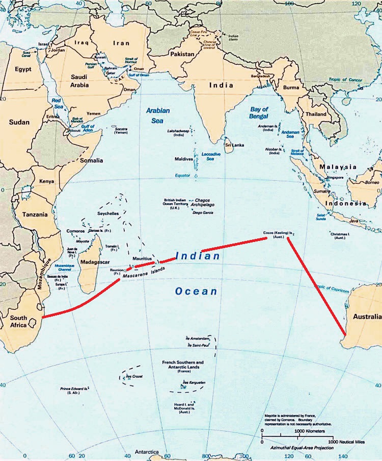
The Cocos Keeling are low-lying islands, but finally about 10 miles out, when we reached the crest of a wave, we spotted a long expanse of palm trees, seemingly growing right out of the ocean depths. We were still showing 6,000 (1,845m) foot depths and there, just in in front of us a few miles, were islands lush with palm trees. We slogged our way into the wide atoll opening between Horsburgh Island and Direction Island, not quite enjoying the cold, wet sting of the waves as they now slapped the side of the boat and rose up, thoroughly drenching us each time.

palm trees in the distance

palm trees in the distance

It was dusk as we rounded the end of Direction Island and watched the depth meter go dramatically from “unreadable – too deep” to 40 feet (12m) in seconds. It was that dramatic. Our electronic charts seemed spot on and the flashing lights shown on our charts were functional. Hallelujah! A small ship was anchored in Port Refuge. We passed by and headed east towards a more suitable depth for Nine of Cups. There is an inner lagoon for sailboats, but the area is dotted with coral heads and negotiating this area at night was not advisable without knowledge of the waters. We were content to drop the hook in 22 feet (6.7m) and call it a day. Even though it was dusk, the water was so clear, I could see our anchor hit the sand on the bottom and coral patches seemed easily distinguished. Dropping the hook, seeing the anchor dig in and finally turning off the engine provided a wonderful satisfaction and relief. A few days R&R (that's repair and regroup) were definitely in order.

We were close enough to the inner lagoon anchorage to count the boats at anchor there … 20! How could this be? This late in the season, we were expecting to have the place mostly to ourselves … perhaps a few other boats, but a whole fleet? Even after we were comfortably anchored, we noted two other sailboats arriving. One was flying a discernible burgee … the ARC! We had checked weather, currents, regulations, things to see and do. We had not checked to see if there were any rallies scheduled to stop in the Cocos.

arc burgee

arc burgee

The ARC, a renowned around-the-world rally from hell, is one of those things that are fun for the those participating and directly benefiting, but definitely not enjoyable for those on the sidelines. They tend to monopolize the anchorages, the services and the locals wherever they stop, leaving non-rally boats at a disadvantage. We plan to find out where they're heading … this might be a passage-altering occurrence.

Back to the arrival … it was pretty much dark when David finished tidying up the deck and I finished de-hurricaning the saloon and starting dinner. We'll have to await morning to get our first real glimpse of the Cocos Keeling Islands. BUT … we're here!

Read all about the Cocos Keeling Islands here.

Continue on our Indian Ocean Crossing from Cocos to Rodriques Island here.

Crossing the Indian Ocean - Day 10

day 10 map

day 10 map

Indian Ocean Crossing - Update 4

Geraldton, Western Australia to Cocos Keeling

Day 10

Remember I talked about how idyllic this trip has been? Well, we're making up for it ...all in one day. The tenth day of our passage was rather action-packed and deserves a separate blog unto itself.

The day started out well enough, the light breezes of the past two days disappeared and Neptune graced us with the trade winds once again. We picked up speed and of course, as the winds increased, so did the seas. We rigged the port settee with lee cloths as our sea berth.

Just after Noon, the AIS alarm went off. A ship, 15 nautical miles away, had a CPA  (closest point of approach) of under one mile. We had a visual on him 6 miles out. His CPA was getting closer - .75nm. We hailed the freighter, Berge Manaslu, a Panamanian registered vessel en route from Brazil to China, to make sure they could see us and asked their intentions. We got a quick response in good English that indicated yes, we were on their radar and they had adjusted their course to port to allow us more clearance room. We chatted for a moment, exchanging pleasantries. Though we would have guessed he would have crossed behind our stern, it appeared he was crossing our bow. He certainly had access to more sophisticated equipment and probably more experience, so we went with his decision.

As he came closer and closer and the CPA showed an imminent collision, we took evasive action. We needed to jibe. Since we were poled out, this meant taking in the jib in record time, jibing, and cutting hard to port to pass behind his stern. We came within .2nm of either being t-boned or hitting him broadside. Huge ocean out there and not enough room for a tanker and a tiny sailboat. We hailed again to ask him what he was thinking, but this time no response to our hails. Whew!

Shortly after resuming our course, we got a solid hit on the fishing line. Hooray ... Fish for dinner. But, alas, we had hooked a white fairy tern known by the locals as the "pilot of the Cocos". Oh, no! I went to grab a towel in hopes we could somehow catch and release him, but David gave me the "kaput" sign, index finger across the throat. He'd been dragged under for quite awhile. He was a goner. Then, like a Phoenix rising from the ashes, he darted out of the water like a shot and flew away. This would have been tantamount to killing an albatross in my book and, oh, the consequences of that!

The winds continued to increase, the seas building, but we were moving along nicely wing on wing until a rogue wave, an untimely gust and an accidental jibe and ...CRASH! The whisker pole snapped in half, leaving two halves with ragged aluminum shards on their ends falling to the deck. David assessed the damage. The mast-end of the pole could not be lifted back into place, so we lashed it to the mast pulpit. After much coaxing, the sheared-off extender tube was freed and lashed to the lifelines above the fender boards.

With the 30 knot wind still behind us and significant weather helm, we wrestled down the mainsail and flew the jib alone, sacrificing no speed and getting a marginally better ride.

Each afternoon, we customarily have a cuppa and two TimTams each, carefully doled out so they'll last as long as possible. TimTams are Australia's favorite sweet biscuits (cookies), so the ads tell us. They come in several varieties. David prefers Original (chocolate) and I prefer white chocolate. After our adrenaline-rich afternoon, we felt most deserving of this treat. I noted with dismay that I only had two left in my package while David had four. At first we attributed it to my being a tad piggy one afternoon, but a closer look revealed David's package contained 11 cookies per package while mine had only 9... 200g vs. 165 g. A grievous difference! How could I have known? Same price, same size package on the outside. How could they expect me to read the fine print? This was grounds for a mutiny until the captain generously offered to give me one cookie from his package, evening out the cookie allotment to 10 each. Mutiny avoided.

The night was a wild ride. We stood two hour watches. It was unpleasant on deck with the boat knocking around in the waves. Salt spray flew off breaking waves and stung our faces. Below, there was no comfortable place to be. The sea berth, though confining, allowed little rest and added to the already mounting list of aches and pains. It was a toss-up which was worse, standing watch or trying to sleep.

And then morning came and, though I wish I could tell you all was calm and fine, it was more of the same. The good news? 62 miles to go to Cocos Keeling.

Today's catch: 6 flying fish, 1 bird, 1 whisker pole, many bumps and bruises, no edible fish, equal amounts of TimTams. That's my story and I'm sticking to it.

Continue on to our arrival in Cocos Keeling.

Nine of Cups' Indian Ocean Crossing Route

We're all geared up for our Indian Ocean crossing. We had originally planned to port-hop up the Western Australia coast, but the clock is ticking and with our delayed departure, we've regretfully opted to skip this coast in favor of perhaps stopping at islands along our route. We've consulted all the guides and internet articles we can get our hands on and determined what our route should be. Deciding on a route has lots to do with predicted weather patterns, currents, prevailing winds and, of course, what there is along the way to entice the crew to stop. During a long passage, it doesn't take much.  

planned route across indian ocean


No matter how well we plan a route, we're still at the mercy of the wind and weather. We strive for the most direct approach, but it's not always possible. For instance, if you notice the map, you'll see that we go considerably north before heading west. That's because we're bucking the south-setting Leeuwin Current and trying to get far enough north to pick up the easterly tradewinds. In other words, we may be tacking a lot, doing zigzags as it were, in which case the 6,100 nm (nautical miles) planned may be significantly more by the time we reach the other side. We'll compare actual to optimal mileage when we arrive in South Africa.


ocean currents


Our plan includes stops at Cocos Keeling, an Australian island territory; the islands of Rodrigues and Mauritius, both former British territories and now an independent island nation; and the island of Reunion, a French Indian Ocean Territory. The distances between stops varies between overnights, a few days and weeks. We anticipate the whole trip to take several months, with hopes of arriving in Richards Bay, South Africa in time to celebrate the holiday season.

Fremantle/Perth to Cocos Keeling – 1,500 nm

Cocos to Rodrigues - 2,500 nm

Rodrigues to Mauritius - 350 nm

Mauritius to Reunion - 120 nm

Reunion to Richards Bay, RSA - 1,550 nm

Total - 6,100nm