That Pesky Chore List

Under Control

That chore list I described when we first arrived here in Lüderitz is actually getting a bit shorter. I know you think we've only been gallivanting over the Namibian countryside and cavorting over deserts chasing wild horses, but in actuality, we're also getting a few things accomplished … and they were actually on the to-do list.

We've had a couple of extremely windy (30-35+ knot) days when there was a chop on the bay and we could see whitecaps all around us. Those were good days for concentrating on inside chores. With so much power, I was able to sew without worrying about power consumption. I fabricated a new dinghy engine cover which I'd been putting off (rather successfully, I might add) for over a month.

new dinghy engine cover

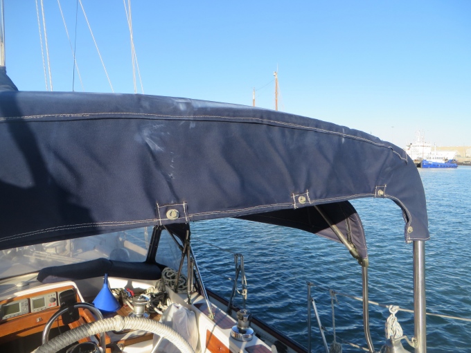
I re-stitched the boom crutch cover, but as usual, it wasn't as easy as anticipated. The twist-locks  which hold the cover in place were pulling out, so they had to be removed. I stitched on reinforcement patches (12 of them)  and then David re-installed the twist-locks. Typical small project that should have taken 30 minutes ended up taking a whole morning. Sewing a new zipper in my foul weather bibs was easy compared to the other two projects. And the chafe guard between the dinghy storage location on the foredeck and the hatch cover was just straight stitching … a piece of cake … for me. David had some problems securing it, but managed after giving it some thought (and choice invectives).

repaired boom crutch cover

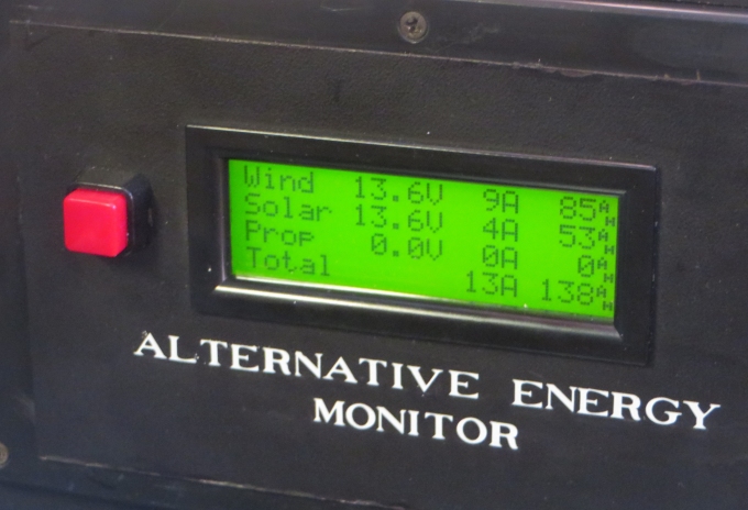
David has been working on a rather clever electronics project: a gizmo that measures and displays the amps and amp hours produced by our alternative energy sources, i.e. wind, solar and prop generator. I'll let him tell you about it himself, but the finished product all mounted and labeled and backlit is pretty impressive. Of course, I'm from the “dark side” (marketing), so what do I know?

alternative energy monitor

David's tackled the calcification in the head hoses … nasty job, but done. The fairleads for the traveler are now in place. He's tinkered with the reef lines and is happy with them now and the shaft brake has been adjusted.

Still, a few more things to do … additions actually. It's time for preventive maintenance on the dinghy engine and before we leave for the Atlantic transit, I need to do the annual ditch bag check. We've eaten up some stores, of course, so we'll need to do a mini-provisioning before we leave Namibia.

With all those chores accomplished, I think it's time for more play. Just need to convince the captain!

Off-Season Passagemaking

We got an e-mail the other day from Catherine in Australia. We've never met her, but it feels like we know each other. We've been in contact off and on over the last couple of years via e-mail. She and her husband have just recently “cast off the lines” and are cruising. She asked about our change in plans and wondered about passagemaking in the off-season. It's surely not the time when most folks set off to cross the Atlantic. She thought it might be a good blog topic and we agree. First of all, as we've said many times, making plans on a sailboat is always done in the sand at low tide. Things change … the boat needs work, unexpected repairs, weather delays, emergencies at home, health issues with the crew or maybe friends need help. We've delayed departures and changed plans many times in the past for these reasons and others. Once we moved a sick friend's boat from Ushuaia, Argentina to Uruguay, leaving Cups on the hard in Panama. When we returned to Panama, only a tiny bit late in the season, there was a slow-down (read that “strike”) of Panama Canal workers and we didn't get through till two months later … too late to cross the Pacific. What to do? We visited old friends in Ecuador, then headed to Puerto Montt, Chile to visit more friends there. We dawdled in the Patagonian canals and Chiloe (not a bad place to dawdle, by the way) and waited till it was reasonable to cross the Pacific and headed across from there.

plans at low tide

We were late leaving New Zealand when David's Mom was ill. We opted to stick around another season to explore the South Island till cyclone season was over in the Pacific. In Australia, Cups stayed in Adelaide for months while Marcie's mom recovered from an illness. The next year, we were late leaving Mandurah, Australia  to cross the Indian Ocean when Marcie's mom died.  These are unavoidable circumstances and going with the flow is the best philosophy. We still made it across the Indian, but at a less relaxed pace than we would have liked. We missed some places we would have liked to see.

That said, wind, weather and currents many times dictate our passage-making plans. We consult Jimmy Cornell's World Cruising Routes 
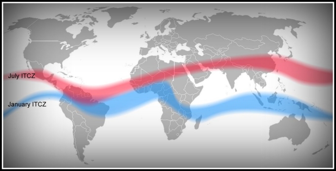
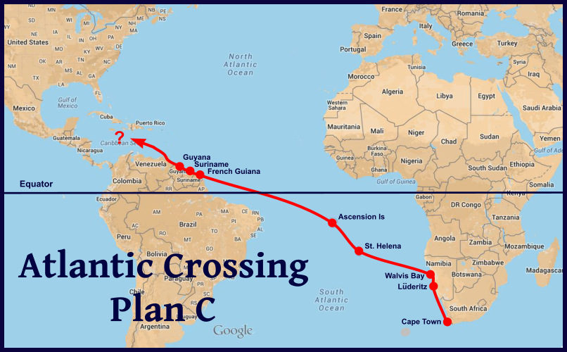
and wind pilots, as well as available cruising guides and notes from friends. Most Atlantic crossing guides talk about crossing from the US to Europe and back. Fewer guides talk about the South Atlantic crossing. We've done it twice before from both directions, but at different times of the year. One crossing was rough (Uruguay to Cape Town) and one crossing was the stuff dreams are made of (Cape Town – Charleston,SC).

plan a plan b

Once again, we're late …  leaving Africa is best done January-March if you're heading back to the States. Repairs and weather mostly account for our late start. The hurricane season is now in full swing in the northern hemisphere. So how does that change our plans? Well, crossing the South Atlantic this time of year is not the problem since tropical and subtropical hurricanes are rare south of the Equator and  when they do occur, it's in the austral summer. Additionally, the problem of crossing the ITCZ (the InterTropical Convergence Zone) this time of year is less of a challenge, since it sits further north above the Equator in the austral winter.  The problem is once we cross the Equator, where do we go?

itcz january to july

We had originally planned to head out across the Atlantic in the February/March time frame with a destination of the US east coast, probably the Chesapeake, via Bermuda. That was Plan A. Then, there was Plan B. We'd head out in the April/May timeframe and perhaps head to the southern Carib … Trinidad, maybe. We're now working on Plan C. We'll hang in Namibia … Lüderitz and then Walvis Bay further up the coast … till the August time frame and then head across the Atlantic via St. Helena and Ascension as originally planned. Instead of heading into the Caribbean, we'll head to the Guianas … three small South American countries we've yet to visit. None of these countries suffer from hurricanes … only heat and humidity. They're a good point of sail and on the way, and will provide a good entrance into the Caribbean once the hurricane season has passed. The Chesapeake will have to wait till next Spring.

plan c

Being flexible is key when you're cruising … especially on a sailboat. There are times when it's prudent to wait and other times when it makes sense to alter your plans a bit to fit with Mother Nature's plans.

stay flexible

The world is huge when you're sailing and 70+% of it is water. There's always somewhere to go. By the way, we've begun to think of it as being extremely early for next season as opposed to being particularly late for this one. It's all in how you look at it!

Thanks for this blog post idea, Catherine! Anyone else have any ideas for blog post topics? We're wide open to suggestions. Leave a comment or send a quick note via our contact page.

The Blue View - Horse Latitudes

For some odd reason, I always thought the horse latitudes were synonymous with the doldrums near the Equator, but they're not. There are two high pressure bands that lie between 30 and 35 degrees from the equator in both the Northern and Southern hemispheres, which for centuries have been referred to by sailors as the horse latitudes. Both areas experience little or no precipitation, and variable light winds. Sailing vessels were often becalmed in these regions – thus in the north, the area was known as the Calms of Cancer and in the Southern Hemisphere it was known as the Calms of Capricorn. horse latitudes map

The earth also has three bands of low pressure – one near each of the poles and one lying at or near the equator. Since wind flows from a high pressure area to a low pressure area, the areas between the horse latitudes and the equator have much more consistent winds – the trade winds. Likewise, between the horse latitudes and the polar lows, the winds produce the westerlies. Mariners of long ago may not have known what caused the trades and the westerlies, but did know how to take advantage of them. They also knew that they were likely to be becalmed in the horse latitudes, and tried to spend as little time as possible in them.

As an interesting aside, the consistently warm, dry air of these regions are partially responsible for the formation of most of the earth's subtropical deserts; the Sahara, the deserts of the southwestern United States, northern Mexico, and the Middle East in the Northern Hemisphere, and the Kalahari, the Namib, the  Australian, and the Atacama deserts in the Southern Hemisphere.

horse latitudes wind chart

There are several theories about how the horse latitudes got their name. The most prevalent legend is that the Spanish ships often transported horses to their colonies in South America. If they were becalmed for a long period of time in these high pressure areas, fresh water would start running low, and there wasn't enough to spare for the horses. The dead or dying animals would be thrown overboard. I suspect that if the legend is true at all, the horses would have been eaten rather than thrown overboard. Maybe it was named the horse latitudes because it was where the crew got to feast on horse meat instead of the usual limited rations of salted beef.

one theory

Another theory is that the name came from the “dead horse” ritual of sailors. Seamen, when signing on for a voyage, would receive an advance in pay, which was meant to be spent on gear and clothing for the voyage (but more likely was spent on drink and debauchery in the hours before departure). It was usually a month or two into the voyage before the debt was worked off, and this period was called the “dead horse” time. A celebration was often held when the debt was paid off, and it usually corresponded to about the time the ship reached the area of calms.

A third explanation comes from old maritime terminology. A ship is being horsed when it is being carried by a strong current. In an area of light or calm winds, the sea currents and tides would have more effect on the progress of the vessel than the wind. Its forward progress through the horse latitudes would depend on how much it was being horsed.

Whatever the explanation, the horse latitudes in the South Atlantic near Africa are quite narrow and fortunately, our passage is reasonably fast. Whew … that's a relief because we weren't looking forward to eating or throwing any of our horses overboard.

And lest you think we've forgotten, Happy 239th Birthday, America. Though we won't be celebrating with fireworks and family barbeques, we've got the 4th of July spirit aboard Nine of Cups and our American flag is flying.

happy 4th