Along the Intracoastal Waterway
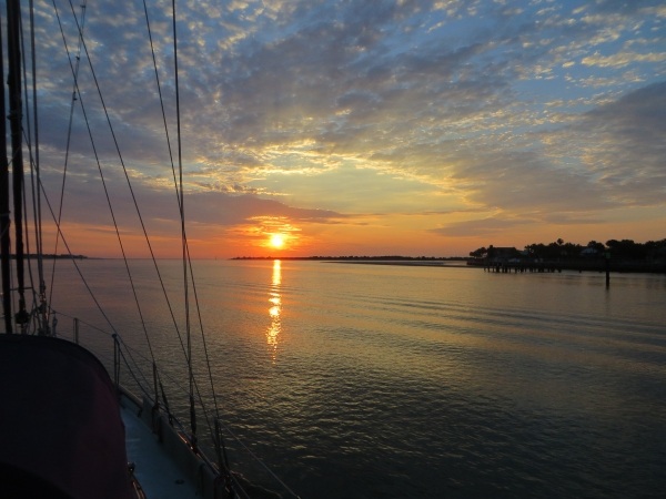
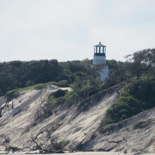
Day 2 – 637 nm to go We woke to a glorious, clear-skied morning on the ICW. We could really get into this. We were anchored just off the National Parks dock and Cumberland Island begged exploration, but we said no this time. We were anchor up by 0630 and on our way heading up the Cumberland River. David had plotted the day's course the night before while I prepared dinner, so we were ready to go. The water was flat calm, nary a ripple to be seen. The Little Cumberland Island Lighthouse poked its head into view as passed the north end of the island.

little cumberland island lighthouse

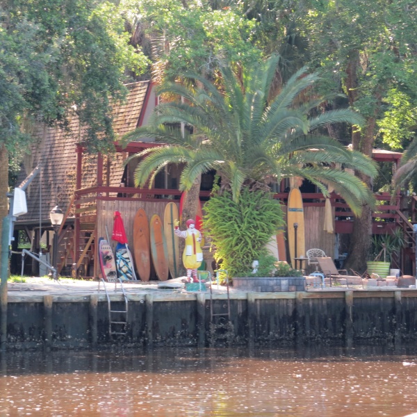
We pass by clusters of home from time to time along the canals. Some are palatial and others just river shacks. Some of the owners have a sense of humor.

ronald mcdonald waves at us

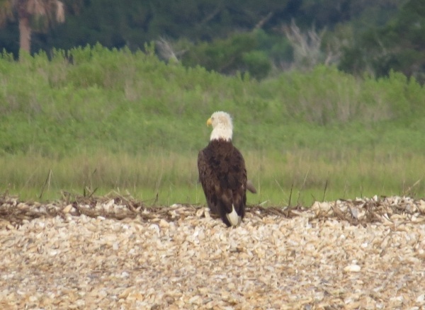
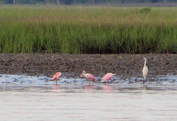
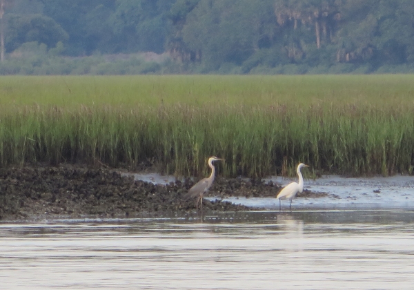
Mostly though, the scenery has been pastoral and pleasantly ever-changing. Bright green grassy banks line the rivers of these Georgia marshlands. The day turned hot and sultry by 10am and we were thankful for light cloud cover and a slight breeze. Herons and egrets, just a couple boat lengths away wading along the muddy shores, ignored us as we passed, more interested in their morning's breakfast.

wading birds on a grassy shore

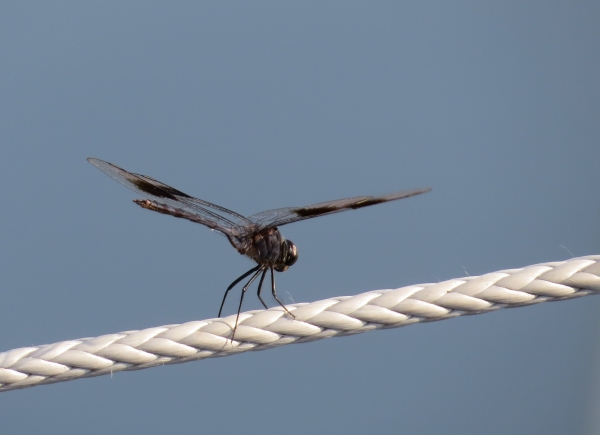
Dragonflies, butterflies, bees and huge horseflies hitched rides with us throughout the day. One dragonfly, the size of a hummingbird, lighted on the lifelines. I snatched my camera for a picture, but the “change battery” light came on. Figures. I scampered down below, got a new battery, changed it and came back up. Believe it or not, that vain dragonfly was still there, just waiting for his photo to be taken.

dragonfly

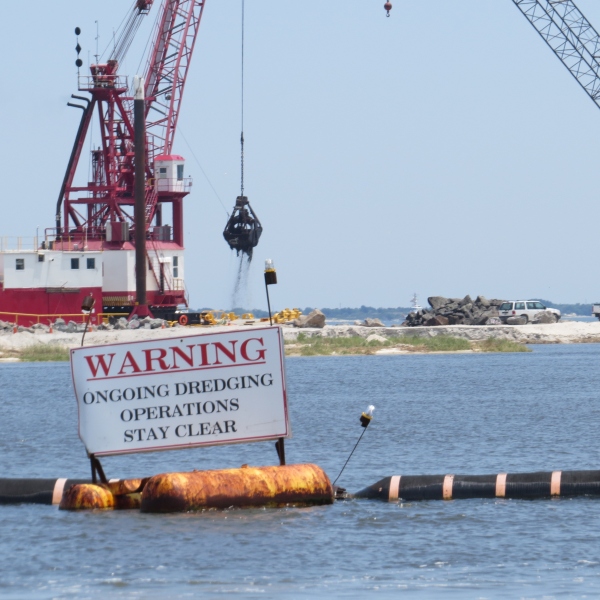
Each day presents a minor adrenaline rush with its shallows and narrow canals. These are not life-threatening nor boat-wrecking events. The worst that would happen is we would be probably be grounded in mud and sand. Still, we're used to traveling on the ocean where the depth meter seldom registers. Watching the depth meter plunge below 10, then 9, then 8 feet is unsettling with our 7.2' draft. Day 1 the major bugaboo was the Fernandina Shallows where we saw (and felt) a 7' spot under the keel. We plowed through the few feet of mud and felt as if we had done a bit of dredging for sailors in our wake.

Today's tough spot was the Jekyll Creek along the west coast of Jekyll Island. Once again, the depth meter plunged and we were close enough to the dock at the Jekyll Island Marina to nod hello and say a few words to the folks moored there without raising our voices. Because of the ongoing movement of the river waters, silting and shoaling are constant issues and though we see dredging operations regularly, it never seems to be quite enough.

dredging in progress

Around 3 pm, the VHF wailed a violent storm warning for the local inland waters. Though there was some cloud build-up, we never saw a drop of rain nor an increase in winds. We counted ourselves lucky for dodging yet another weather bullet.

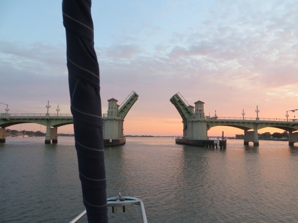
We're fascinated by the names of some of bodies of water we're passing through like the Little Mud River (hmm!), Buttermilk Sound, Old Teakettle Creek and DoBoy Sound. We wind and wend our way through this maze of waterways. Thank goodness for GPS.

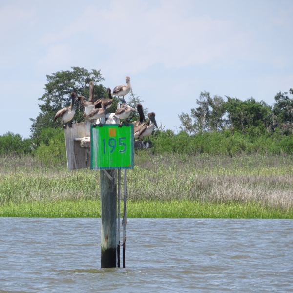
Pelicans were out in force today. They'd careen past us at top speed, dive into the water, swallow their catch (or perhaps just a lot of river water) and then fly off again. When they weren't fishing, they congregated wherever they could for some socializing. We wondered just how many more pelicans could have fit on the top of this marker.

how many pelicans can fit on a marker

It was nearly 5:30 pm when we quit for the day. We found ourselves a pleasant little anchorage out of the current in the Crescent River just off the main channel. With the engine off, the quiet was nearly palpable. It was hot and humid below, but sitting in the cockpit after a long day, enjoying a cold beer (yes, there's still some ice left) was heaven.

Breaking Free from St. Augustine

St. Augustine to Chesapeake We enjoyed our time in St. Augustine just a little too much. Our one week layover became two weeks without a thought. There's so much to see and do here and we've hardly touched the surface. We never made it to the main fort, Castillo de San Marcos. We'd still like to check out some of the beaches. There are more walks we'd like to take and more museums to visit. Maybe next time.

Departure plan delays haven't just been our fault. Tropical Storm Bonnie kept us in port for a couple of days, waiting her out to see what she'd do along the Carolina coast. Then we waited a couple of days for southerly winds again. We made plans to leave one day, then thought better of it and postponed till the next. Then the next morning came and we didn't feel like leaving. We finally pulled ourselves together, gave ourselves a stern talking to and managed to prepare for a timely departure. Then Tropical Storm Colin came along.

Weather forecasts differ. We always wonder  if the weather forecasters and the news broadcasters just hype it a bit too much (duh!), providing all the worst scenarios to catch the headlines and not providing more realistic forecasts. Still … we prefer to be prudent, so we stayed put and in retrospect, glad we did. We've been in storms and cyclones before and it's not pretty. We'd begun to think of St. Augustine as something of a magnet, keeping us here. We were having problems breaking away.

IMG_0002

Tropical Storm Colin arrived and departed and we were no worse for the wear, but he left heavy seas and northerly winds in his wake. We waited for two more days and then … finally … a reasonable weather window appeared. We got up, checked the weather and our southerly winds had vanished during the night. The heck with it … we'll motor up the Intracoastal Waterway (ICW) for awhile then we can head out an inlet when the winds were favorable.  Enough waiting. Let's get on with it. The sunrise was outstanding.

Day 1 – 635 nm to go (outside) or 706 nm on the ICW

IMG_0003

We headed out through the Bridge of Lions at 0630 towards the end of a low tide. The friendly bridge keeper waved and wished us a safe trip. As we sailed past the city and the fort, we felt the tiniest tug. This is an endearing city. We'll be back. The near slack tide gave us no resistance as we traversed the inlet and headed up the Tolomato River, the course of the ICW headed north. Instead of searching for the Gulf Stream, we were trying to stay between the lines in the channel.

IMG_0005

Our experience with the ICW was admittedly limited, but we were a bit negative about it. It was slow and circuitous; we were motoring, not sailing; all that fuel, etc., etc. Just a few miles up the river, I spotted a bald eagle sitting on the shore. My negativity faded quickly.

IMG_0001

Further up, I spotted roseate spoonbills. There were egrets and herons everywhere … pelicans, terns and black-headed gulls. The traffic we feared was minimal. It was late in the season for folks heading north. We found ourselves pretty much alone with  a trawler or two politely notifying us before they passed.

The scenery was beautiful for the most part … tall grass marshes, bright green grassy banks, sea oats swaying in the breeze. Dolphins worked the river and we saw them frequently. A ray jumped up several feet out of the water. Turtles poked their heads up, then submerged again. Manatees lumbered along close to the grassy shores. We agreed … this really isn't so bad.

Thanks to our new friends Cheryl  and Doug on Renaissance, we discovered Active Captain, a free download for sailors with lots of local knowledge and specifics on transiting the ICW … everything from shoaling and strategies to marinas, restaurants and points of interest along the way. It saved our bacon on a couple of occasions and though we disliked some aspects of the program, overall, we found it quite helpful.

We found a fine anchorage in Cumberland Sound South, just off Cumberland Island, Georgia for the night. (Thanks, Benjamin, for that suggestion). This is a National Seashore Reserve and beckons more time which we didn't have. We didn't get to go ashore at all, but it's on the wish list for our next trip down.

So we've stopped whinging about the ICW and actually, we're starting to like it. We plan to spend at least another day or two on this circuitous route north … maybe even go all the way. Who knows?

Riding Out Tropical Storm Colin - Pt. 2

By definition, a “tropical storm” is a cyclone which originates in the tropics and attains sustained wind speeds between 34–63 knots (39–73 mph/63–118 km/h). It's one step below a category 1 hurricane. An eerie calm had descended upon the anchorage. There were none of the usual boat sounds … no fishing boats or cigar boats whizzing past up the channel. No jet skis. The tour boats didn't go out. There was no wind. The only movement of water was driven by the current and it was so quiet we could hear the lap of water against the hull as the water passed by. Everyone and everything seemed poised ... waiting for Tropical Storm Colin to arrive. It was the proverbial “calm before the storm”. Calm and disquieting.

tropical storm colin

We'd already stowed the dinghy and prepped for departure, so there wasn't much to do other than check and double-check. We lashed down the bimini. We busied ourselves with odd chores on board throughout the day, seemingly busy and casual, but the anticipation of the impending storm was always there.

We had brief showers on and off during the day and the skies were dark and forbidding. We waited and waited. We ate dinner around 7pm. It was still pretty quiet. We're not good at the waiting game and the angst was palpable. It wasn't until 9pm that we heard the first real rain begin to fall. Then it came in buckets. Hard, hard rain that emptied the sky and kept on coming. David's hatch repairs were being tested and seemed to be holding just fine. It became stifling below decks … hot and muggy with all the hatches and ports closed.

The wind soon caught up with the rain. We could hear it approaching like a freight train and then the howling began. It whipped through the rigging. Previously well-behaved lines and halyards banged and clanged. The incoming strong current was at odds with the winds and Cups heeled over as she took the winds broadside. A few things not stowed after dinner went flying off the counter … my bad. The mooring ball, driven by the strong current, clanged against the hull with loud thuds. David went on deck innumerable times to check the ball and look for chafe in mooring lines. Each time he came back below soaked to the bone after only minutes on deck. All was fine. We chatted, watched movies and sipped tea. There was no sleeping.

The tide finally began to change just after 11pm and the current got in sync with the wind. Cups was clearly more comfortable and so was her crew. The thunder and lightning began, but only one bolt appeared to strike close by. The others lit the sky spectacularly and blasted us with a few loud cracks, but posed no threat. We checked for weather updates frequently. Some waterspouts had been sighted earlier in the day in other parts of the state, but none in the St. Augustine area. We saw a max of 40 knots on the wind speed indicator … a good sailing day for our South African friends in Cape Town … but we were definitely out of practice for storm force winds.

waterspout

By 2am, the worst that Colin was dishing out had passed. David made one more walk around deck, checked the mooring lines and we headed to bed … tired, but relieved. All told, it was certainly not the worst storm we've endured, but we were glad it was over. Colin is on his way northeast to Georgia and the Carolinas and then is expected to head offshore to the hurricane graveyard.

We woke just after 7am. The sun was trying to shine and the sky was a patchy blue. Cups seemed no worse for the wear and her decks were clean and salt-free. We discovered a few new leaks, but nothing major … something to add to “the list”. We noticed one sailboat at anchor nearby with its torn and tattered jib fluttering in the morning breeze. The rest of our neighbors appeared to be just fine. The marina launch made a pass through the mooring field asking if we'd had enough wind. Definitely.

tattered jib

The worst is over and we'll be on our way soon once the seas calm down a bit and the southerly winds return. In the meantime, we return to our adventures in St. Augustine. Once we're en route to the Chesapeake, we'll update you with passage notes.