Paramaribo - Suriname's Big Smoke
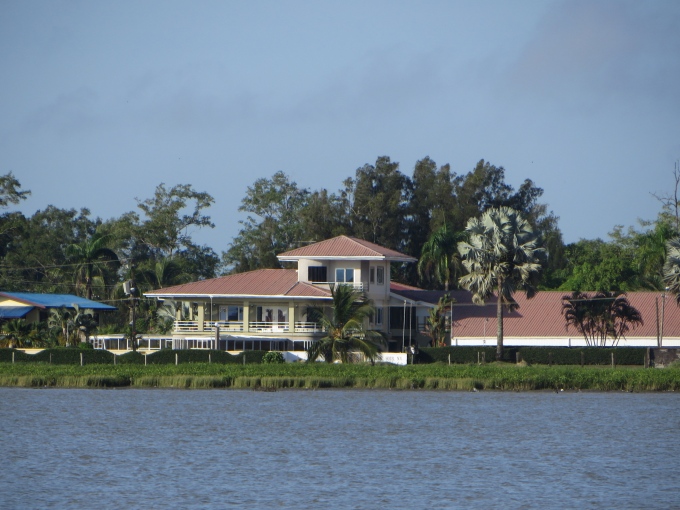
paramaribo surinames big smoke Paramaribo (Pah-ra-MAHR-ree-bo), Suriname's capital city, is only 10 nm down the river from us, but by bus … it's a 1.5 hour circuitous ride on a very limited two bus/day schedule. Through the marina, we hired a car from a local fellow … €10/day, unlimited mileage … and off we headed in an old Toyota towards the country's big smoke. The locals call it Parbo ... just like the beer. It seems the best view of the city's foreshore was from Nine of Cups as we sailed past a few days before.


paramaribo foreshore view

Paramaribo, probably a corruption of the AmerIndian village name of Parmirbo, was originally settled by the Dutch as a trading post in 1613. It fell into English hands when the Dutch abandoned it and the British built a fort on the site called Fort Willoughby. In 1667, Suriname was given back to the Dutch in the Treaty of Breda. They renamed it Fort Zeelandia, as it is today, and renamed the city New Middelburg (evidently that name never caught on). Paramaribo grew after the abolition of slavery in 1863, attracting many former slaves to the city.

Our first stop was Tourist Info housed in an historic building and located near Fort Zeelandia. For some reason, tourist info is only open Monday-Friday 0900-1530. (Heaven forbid, it would be open on the weekends when people had time off and wanted to get info.) The women were pleasant enough, but had very little information available … a city map, but no country map, and a few commercial brochures for restaurants, hotels and tours.

paramaribo tourist info office

We decided Fort Zeelandia would be our first stop since it was close by and also had limited hours. On the way to the fort, we walked along a shady, tree-lined street past homes that were the residences of former military officers.

paramaribo dutch colonial houses

We paid our admission fee (SR$20/pp) and entered the fort which also houses the Surinaams Museum. The fort, “the oldest monumental building in Parmaribo”, has been carefully restored and its brick walls and bastions have historically been the hub of this UNESCO World Heritage city.

fort zeelandia paramaribo

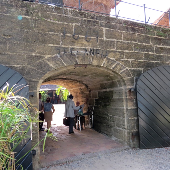
The fort's many rooms have been converted into the Surinaams Museum, a rather eclectic mix of Suriname history and culture. A wide open courtyard greeted us on the other side of the short entrance tunnel. A pleasant little cafe, Baka Foto, provided us with our first coffee of the day.

fort zeelandia courtyard paramaribo

One room was dedicated to the “apotheek”, an old Dutch pharmacy displaying lots of apothecary jars, bottles and pharmaceutical miscellany. All the signs were in Dutch, but we got the gist of the display.

fort zeelandia apotheek paramaribo

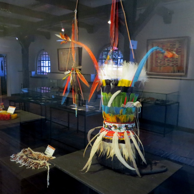
The fort is not very large and never really fulfilled its mission as a fortress. It was too easy to sack … a French pirate, Jacques Cassard, proved the point in 1712 when he plundered the city. We climbed the stairs to the second story and admired the view and the breeze of the Suriname River from the bastions. AmerIndian and Maroon artifacts and handiwork were displayed in several rooms there.

maroon aritfacts fort zeelandia paramaribo

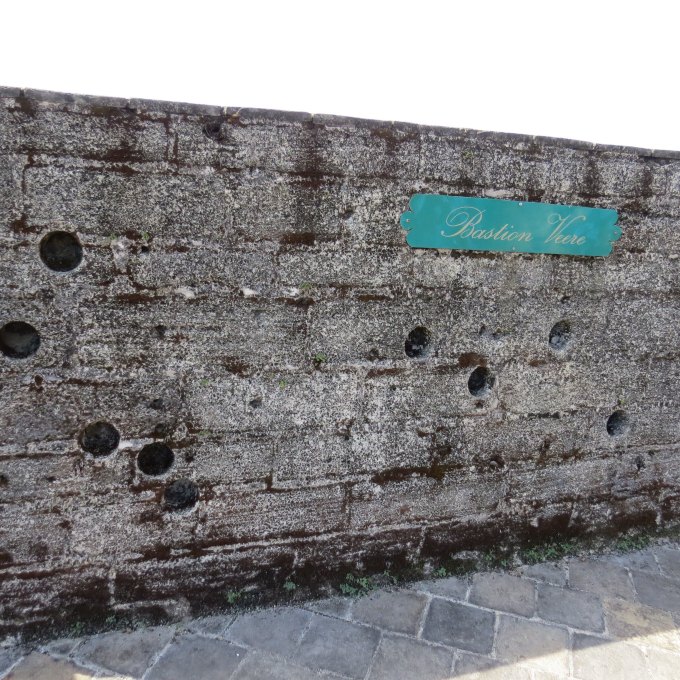
Beyond its role as a fortress, the fort has operated as the site for criminal and slave punishment including hangings. For nearly a century (1872 to 1967), it was used a prison known as “Gebouw” (Devil). It was converted into a museum in 1972, but taken over by a military regime in 1982 until 1994 when it was converted again into a museum. What we missed because of our lack of Dutch language skills, was the sign on the Bastion Verre. A fellow museum visitor, a Dutchman, asked if we'd seen “it”, the site of the Decembermoorden (December murders) that took place December 8, 1982. He led us back to the spot and reiterated the story of 15 prominent men who were tortured and killed on this spot because they criticized the current government. Bullet holes in the wall attest to their fate. According to their website, “The events remain controversial today, as the exact circumstances are still unclear, but the current president of Suriname is the main suspect.”

bullet holes fort zeelandia paramaribo

Climbing to a dusty, stuffy, hot attic area, we found information on Suriname's independence in 1975, as well as small displays on the influences of different immigrant groups especially Indian, Chinese and Indonesian. The fort and museum were a good introduction to Suriname and the city.

asian artifacts

It was time for lunch and we were hankering for a roti, those delightful Indian creations of curry wrapped in flatbread … kind of like an Indian burrito. We found a roti shop (they're everywhere) and indulged ourselves. We washed them down with a djogo of cold Parbo, the national beer and then got under way again.

parbo beer in suriname

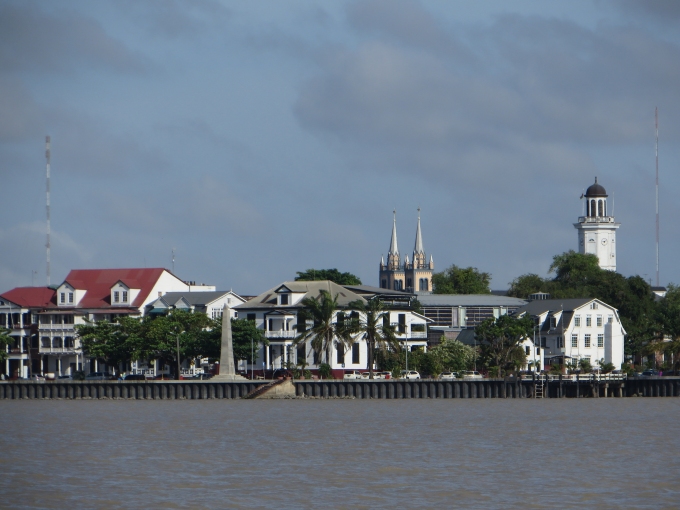
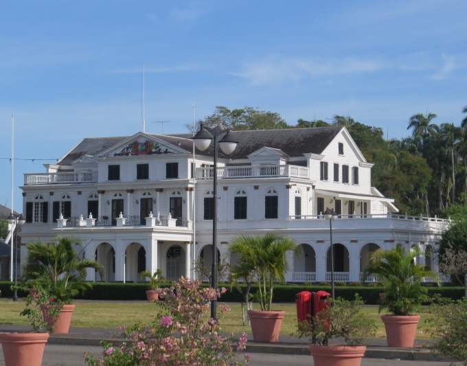
Back on our walking tour track, we walked past the Presidential Palace, a pretty impressive place opposite Onafhankelijkheidsplein (say that three times fast … actually, say it just once if you can) aka Independence Square.

suriname presidential palace

The Ministry of Finance building incorporated the clock tower we'd seen when we'd sailed past. We noted on closer inspection that the clock was about 40 minutes fast.

ministry of finance suriname

The Palmentuin (Palm Tree Garden), just behind the Presidential Palace, is Parmaribo's only public park. Originally a 17th century vegetable garden, the 10-acre in-city park is home to about 1,000 palm trees, providing shade along its meandering paths.

palmentium paramaribo

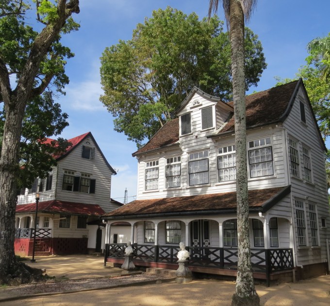
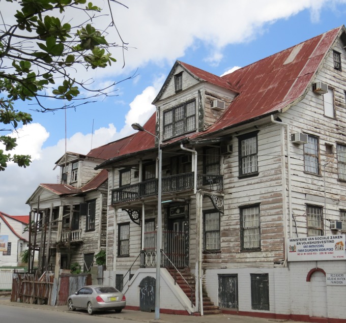
We headed to the Waterkant (waterside), the road along the foreshore, where many of the historic wooden mansions stand. The designs are clearly inspired by Dutch architecture of the time, but we're told “incorporate a range of indigenous techniques and local materials.” Painted a crisp black and white, the Dutch style was evident in its eight-over-eight windows, dormers, shutters and decorative embellishments, reminiscent of houses we'd seen in South Africa not so long ago. Most of the current mansions originate from the first half of the 19th century however, as they had to be rebuilt after large city fires in 1821 and 1832. We walked up Mr. Lim A Postraat (Lim A Po Street) for more of the same.

waterkant houses in paramaribo

There are probably more dilapidated historic buildings than there are restored ones. Many of the wooden houses are in dire need of restoration, to the point where UNESCO has urged the government to address the problem with threats of revoking the city's world heritage status. Remarkably, despite the decrepit look of the houses, many still appeared to be occupied.

dilapidated house in paramaribo


another dilapidated house in paramaribo

Enough walking for the day, we headed to our hotel for the evening...the Hotel Paramuru. After my success in Cayenne scoring a beautiful suite at the Hotel Palmistes, I was hoping to continue my winning streak in Paramaribo. I was able to book the penthouse at a weekend rate of $50US per day. The website pics looked great. The description was awesome. The reality … a bit disappointing. The elevator ran to the third floor and we lugged our luggage up a rickety metal/wood spiral staircase to reach the “penthouse”. The bath was a shower/toilet/sink only with much to be desired. The bed was lumpy, the pillows thin and the bed linen … well, let's just say, it wasn't quite what we expected. But you know what? It really didn't matter. It had A/C that worked, the shower had hot/cold water and there was a little fridge that managed to keep our Sauvignon Blanc cold. We were together exploring Paramaribo, Suriname. Really … who can complain?

paramuru hotel paramaribo

Today's Dutch word “djogo” -jug, in this case a liter bottle of Parbo beer.

djogo

More Parbo exploring tomorrow.

Book a trip to Paramaribo, Suriname...or anywhere you want! Find the best deals here:

About Suriname

about suriname Known as Dutch Guiana before its independence from the Netherlands in 1975, Suriname is about the size of the US state of Georgia and considered by some, to be the best of the Guianas for tourism. We're about to find out. Wedged in between Guayana, French Guiana and Brazil with the Atlantic coast to the north, there continues to be border disputes with the neighbors.

map of suriname

The official language here is Dutch, but English is widely spoken as is the local language known as Sranan Tongo (Surinam tongue) or Takitaki. Our Dutch is a bit rusty … okay, it's non-existent, but we're picking up a few words as we go. We certainly know yes/ja (yah), no/nee and beer/bier. A local woman, Pamela, who works at the yacht club is helping with translations. Today's word was “kip” - chicken. She's also described some of the local Javanese dishes served here … for instance, bami and nasi (fried noodles and fried rice). We'll figure it out as we go. That's half the fun.

suriname menu

We'd actually cleared into the country when we visited Albina just before we left, so we were saved the hassle of taking a bus or taxi into Paramaribo to handle all the formalities. We had to purchase a Tourist Card (€20/pp) at the Surinamese consulate in Saint-Laurent before entering Surinam, payable only with a credit card. They added a €2 handling and VAT fee. We completed a rather long form in duplicate for the Immigration fellow in Albina. Then stamp, stamp, stamp. The process was easy and painless, however. We have 30 days to visit Suriname before having to renew.

passports and visitor cards for suriname

The currency is the Surinamese dollar (SRD) with a current exchange rate of 3:1 to the US$. However, most hotels and even the marina here, charge in Euros (€) or US$ because of the significant fluctuation in the local currency. Credit cards are not accepted as widely here as they were in French Guiana. Cash is king, a tough transition for credit card kids like us. In general, things are considerably cheaper here than in French Guiana, a welcome change. But, of course, we're missing our 70¢ fresh baguettes and croissants.

suriname dollars

The Dutch were the first to settle land in the Guianas. They formed the Dutch West India Company in 1621 and traded with the local AmerIndian people. Cocoa and sugar plantations were established along the rivers with the locals supplying much of the labor. When the locals were nearly wiped out by diseases introduced by the Dutch, slaves were imported from western Africa. Escaped slaves known as Maroons formed their own settlements in the interior, maintaining much of their African culture and language. These Maroon villages still exist today in central Suriname. Maroon wood carving is considered some of the best in South America.

It was the British, however, who founded Paramaribo, Suriname's capital city, on the banks of the Suriname River in 1650. In the Treaty of Breda (1667), the Dutch chose to retain Suriname and their colonies on the Guyanese coast, but ceded French Guiana to France. The Brits also got New Amsterdam in the trade ... better known today as Manhattan, New York. Ouch!

suriname flag

When the British banned slavery in 1834, they also discouraged all slave trade in the Caribbean forcing plantation owners to seek other cheap labor. Enter a huge influx of Asians especially from India, Indonesia and China. Today's Suriname reflects this very diverse, quite harmonious, ethnic mix. Politics in today's Suriname, however, is a different story ... about which we'll make no comment.

A little Suriname trivia for you …

  • Suriname is the smallest country on the South American continent. And, by the way, it's the 12th of 13 South American countries that we've visited. One more to go … Guyana.

  • The country is sparsely populated, ~500,000 people, half of which live in the Paramaribo area.

  • This is a beer-drinking country, although they produce excellent, inexpensive rum as well. The local beer is Parbo. The local rum is Borgoe and it runs about US$9/liter.

    parbo beer in suriname

  • In 2002, the country's capital city, Paramaribo, was listed as a UNESCO World Heritage site.

  • The country’s name is believed to be derived from a Taino group called Surinen, who first inhabited the region.

  • The bauxite (aluminum ore) industry dominates the country's economy. It comprises more than 15% of the GDP and 70% of export earnings.

So, what's on the agenda while we're here? Chores, of course. Varnishing is key... followed by the usual stuff … deck washing, laundry, cleaning and a few repairs and routine maintenance. Then, there's all that sightseeing that must be done. We're hoping to spend a weekend in Paramaribo to see the sights,and perhaps a trip into the jungle if we can find one that fits our budget. We'll definitely be busy, so why not clear your schedule and come along? We could also use a little help with the deck chores, in case you'd care to volunteer.

Down the Maroni...Up the Suriname

down the maroni up the suriname Suriname is either 1.5nm directly across the Maroni River from us (Albina) or ~150nm to a safe anchorage at Domburg, about 35 miles up the Suriname River, and 8 miles north of Paramaribo, the country's capital city. After three weeks in French Guiana (my, how time flies), we're heading back down the Maroni River.

coastal route

The tides dictate boat movement on the river. We needed to wait for an ebbing tide in daylight to carry us down the Maroni back to the Atlantic, and then wait for a flood tide on the Suriname River, to get us upriver to Domburg. Luckily, the total distance is only about 150 nm and there are a few spots to anchor in the rivers while waiting for the proper tides if need be. The tide tables provided on our Navionics charting software are reliable and good indicators for planning departures and arrivals.

tide tables

The tide wasn't changing till near 1100, so we had plenty of time to do morning chores. We wrote and did final internet. David cleaned the dinghy on the shore while I walked into town for our last French baguettes and croissants. We paid our last week's bill at the marina (13 beers, really?), hauled the dinghy, got everything stowed. The tide was just turning as we slipped our lines off the mooring. As we passed through the mooring field, we waved goodbye to new and old friends, wondering which of them we might see again in some other anchorage.

We followed our inbound track 27 nm down the circuitous Maroni, making the outbound trip a bit less stressful than the upriver trip had been. The wind picked up to 20-25 knots on the nose about half way down, causing short, square muddy brown waves to smash against the bow… wind against current and a bumpy ride. With the ebbing tide to carry us, however, we were spit back into the Atlantic just 3.5 hours later.

maroni track

A toast to Neptune and we were headed west towards Suriname on a beam reach. David lowered the French courtesy flag and raised the Suriname flag.

raising the suriname courtesty flag

The winds petered out before midnight and we made the decision to motor when our speed dropped to less than 4 knots. Though we were 8-10 miles offshore, the water is still quite shallow at 25-35' (10m). Fishermen were out in great numbers. Some boats were lit, some not. They laid out great nets with a strobe to mark the end of the net, then waited downwind a mile or more stretching out the net. Knowing which side of the net to pass was the challenge. If we could spot their boat, just a tiny point of light in the vast darkness, it wasn't difficult. If their boat was unlit or too far away, it was a crap shoot. Neptune was looking out for us and we managed the 80nm avoiding all the fishing boats and nets.

We were at the mouth of the Suriname by 0530. It was still dark, but the flashing channel markers and the light of the gibbous moon guided us up the channel entrance. The fishing fleet was just returning to port as well, and we followed along in good company, waving at the homecoming crews. The sun rose at 0615 and we began to see river sights.

fishing boat in suriname waters

The Suriname River was just as muddy and brown as the Maroni, but it was wider and deeper. The channel markers were more frequent; the coastline less wild and forbidding. There were lots of small settlements and we saw fishing stakes laid out close to shore.

settlements along the shore suriname


We reached the confluence of the Suriname and Commewijne Rivers when the current was at its peak and felt the conflicting pull of the current... eddies and whirlpools... as we veered to starboard up the Suriname. Yellow butterflies flew over the the aft deck. We heard the high-pitched chirp of welcome swallows as they fluttered around the boat. One fellow landed on our anchor and bummed a ride upriver.

welcome swallow riding along with us to suriname

As we motored further and further up the river, more industry and towns appear on the riverside. Fishing boats were lined up on wharves and piers.

fishing boats lined up in suriname

Beautiful riverfront homes sprawled along the banks.

beautiful homes along suriname shore

We approached Paramaribo, Suriname's capital city. It stretched scenically along the foreshore, the spires of its cathedral and a stately clock tower dominating the skyline.

paramaribo suriname shoreline

An old wreck marked NDP and noted as “Goslar” on the charts lay just outside the channel. It reminded us of the Edith Cavell off Saint-Laurent,

old wreck off suriname shore

The Brug Surinamerivier (Suriname River Bridge) lay before us, spanning the river, connecting Paramaribo with the town of Meerzorg and points east. It was plenty high enough, but as we slid under, there's always a bit of a catch in our throats as wait to clear.

under the suriname bridge

The shores became less busy as we progressed up the river; the channel markers disappeared. About eight miles up from the bridge, we spotted some masts and knew we'd arrived at Domburg and the Marina Suriname. We headed for a mooring, lassoed it on our first try (no one was watching, of course), tied up and sighed. It was 24 hours from anchorage to anchorage and about 142 nm. Life is good … a new river and a new country.