

A Taste of the Trail of the Coeur d’Alenes
/Lately, we’ve been discussing more possible bike rides on the Great American Rail-Trails (GART). The panhandle of Idaho is a great candidate for this since most of the rail-trail has been completed and it’s only about 90 miles across the state from border to border (Montana to Washington). We had a few days until Blue needed to go for his check-up, so we thought we’d give this trail a try.

Chatcolet Campground in Idaho’s Heyburn State Park, the oldest state park in the Pacific northwest.
Once again, finding a place to camp in a state or national park campground without a reservation can be a challenge. We’ve picked up a few pointers... go early in the morning to claim a site; if the FULL sign is up, check with the camp host anyway; and try to arrive on a Thursday or early Friday morning at the latest, especially if you’re looking for a site for the weekend. With this in mind, we headed to Lake Coeur d’Alene in hopes of finding a campsite to serve as our base for a taste of the Trail of the Coeur d’Alene. The lake is a busy place at this time of year. Heyburn State Park’s main campground, Hawley, was listed as Full, but when we inquired at park headquarters, there was another campground quite nearby, Chatcolet, with a couple of vacancies. We found an adequate site there, set up camp and planned our upcoming ride. Heyburn, by the way, is the Pacific Northwest’s oldest state park.
As it turned out, the Chatcolet campground was actually only a few hundred feet away from the trail.... a very steep, switchbacked dirt path down to the paved lakeside trail. It was too late to start a leg of the trail, so we walked a couple of miles to get a feel for where we’d be riding. It looked very do-able... even the steep ascent trestle bridge which crossed the lake.

The 3100’ trestle bridge spans the width of the lake. Cars have to go miles and miles to get to the other side.

Turtles, gulls and waders beneath the trestle bridge over the lake coeur d’alene

Mama osprey was looking for some help from dad, but he was patently ignoring her calls.
Lake Coeur d’Alene is immense and beautiful. Turtles, gulls and waders stared up at us from atop a small log jam below the trestle. An osprey had nested on the trestle top. Papa osprey sat on a piling in the lake, patently ignoring the calls of mama who needed a change of shift in the nest.
A glass of wine, dinner at the campfire and pleasant thoughts of the next day filled our evening. A note here that though the campsite met our needs, the population of yellow jackets was unbelievable and quite bothersome. They were in our food and in our face constantly... buzzing, taunting, aggravating. Some dove into our wine and drowned. Served ‘em right, but what a way to go. In talking with locals, it seems this is a usual occurrence for this time of year in Idaho and Washington State. Who knew? Certainly, not us.

Getting a taste of the trail of the coeur d’alenes
We were up early, anxious and anticipatory for the bike ride to come. The trailhead is in Plummer, Idaho about 7.2 miles southwest of Chatcolet, so we planned to backtrack to Plummer and then ride back to camp on our first day... about 14.4 miles or so... an easy day for us newbies.
The Trail of the Coeur d’Alenes, named after the eponymous Native American tribe, is 73 miles long and spans most of the width of Idaho’s panhandle. The morning was sunny and cool when we walked our bikes down the steep, dirt path then hit the pavement and began our trek through the Plummer Canyon to the Plummer Trailhead.
This was and is part of the Coeur d’Alene tribal land, and as such, many places along the trail are named in the Salish native language: Hntsaqaqn, ‘Stopping Place’, Hn’ya’)pqi’nn’, ‘Gathering Place’, Hnpetptqwe’n, ‘Place for Racing’. Don’t ask me to pronounce these... I have no idea.

Don’t let the 3% grade fool you… it’s work going up…. but heaven coming down.
The paved trail pretty much follows the path of the old Union Pacific Railroad line, giving it a gentle 3% grade. Don’t let the ‘gentle 3%’ fool you. It doesn’t sound like much, but when you pedal it for 7.5 miles, it’s work. There are mile markers which marked our progress and when we reached Mile 0, we figured we were done, but the trail mysteriously continued on.
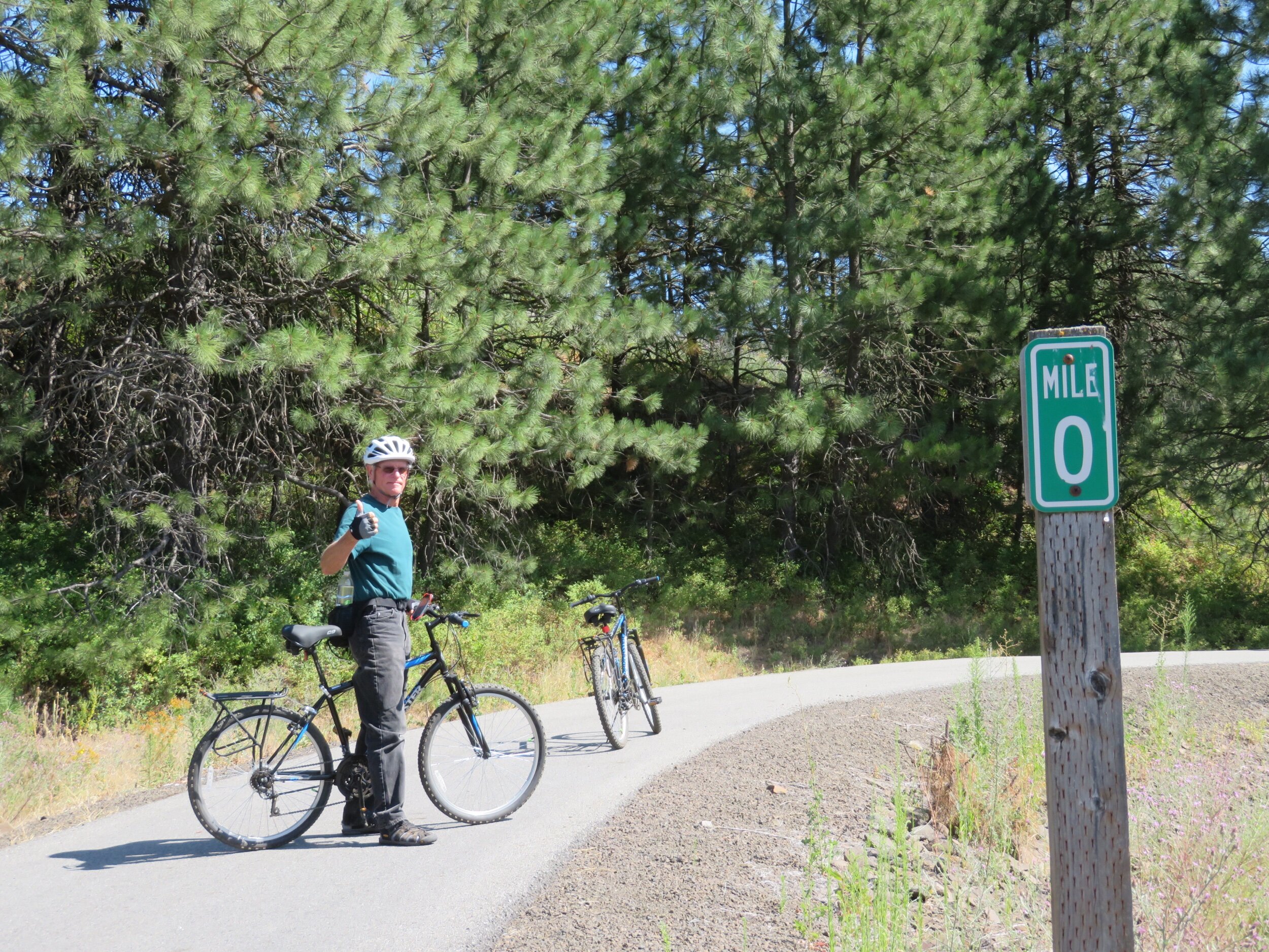
Mile 0 was not the end of the trail… how come?
We learned later that the trail was built as part of an environmental mining super-fund clean-up designed and built in cooperation and coordination with the Coeur d’Alene tribe, the US government, the State of Idaho and the Union Pacific. As the trail was being built, it was determined that not all the mining contaminants could be removed. Since this section of the trail lies within the boundaries of the Coeur d’Alene lands, a compromise was reached. It was agreed that the contaminants that could not be removed, could be buried and sealed under the trail without safety hazards. In return for this compromise, the Coeur d’Alene tribe required that the trail be extended another .7 miles to the current trailhead and a park be established honoring heroes of the Coeur d’Alene.

The answer to the mystery of the .7 mile addition from Mile 0

The trailhead in plummer, idaho
We rested at the park and learned much about the Coeur D’Alenes and their trials in dealing with the United States government. The story is not new, but the details of this particular group of Native Americans was new to us.

Tribute to the heroes of the Coeur d’Alene people
Since we were 7.2 plus .7 miles from Blue, we reversed direction and headed back. That gentle 3% grade that had us sweating on the way up was sheer delight on the way back. The wind in our faces was cool and exhilarating as we sped along the smooth, tree-shaded trail. There are, by the way, tables and benches, restrooms and informational signs placed strategically all along the trail. We didn’t stop much. Going up the trail, we hated to lose any forward momentum. Going back down the trail was so pleasant, stopping might have ruined it.
Back at mile marker 7.2, we walked our bikes back up the steep, switchbacked dirt path to our campsite. All in all, a great day. One caveat: our butts were sore... we really need to toughen up. We planned to ride another leg, sincerely hoping our butts would recover. And they did and we were off in the opposite direction the next morning.

Up and over the 3100’ trestle bridge that spans the lake coeur d’alene
The distance to Springston was a bit longer, but we figured do-able. We started at the same 7.2 marker and our first challenge was crossing the 3100’ bridge/trestle that spans the Lake Coeur d’Alene. The bridge is unique in that both sides ‘stair-step’ up to the center span in an undulating, roller-coaster fashion. Pedaling up was hard, but coasting down the other side was heavenly and allowed us to catch our breaths.

I’ve never seen so many water lilies in my life. They were absolutely gorgeous.

The trail hugs the lakeside for 5-6 miles then travels along side smaller ponds and streams where water lilies provided a spectacular blooming show. I’m not sure I’ve ever seen so many lilies in one place before. A lone white pelican floated along in the midst of the lilies, but left before I could stop, haul out my camera and photograph him. BAH! Osprey nests sat atop light posts and navigational markers and we could hear their distinctive calls as we biked past.
There were lots of bikers on the trail this beautiful morning. The path is flat and easy going. Young and old were out enjoying themselves. We made it to our goal in Springston at Mile 18.3. We shared an apple and headed back the 11.1 route miles to Chatcolet. The return was a piece of cake until the trestle bridge, but even that was a small challenge. We were feeling pretty chuffed. A total of 23.2 total miles today for these old geezers. We’re getting the hang of this biking stuff... and we like it... except the sore butt part.
A couple of lemons are thrown our way in the next few days, but we’re old hands at making lemonade out of lemons. Join us next time for an interesting biking alternative.
Continue on the Trail of the Coeur d’Alenes or