

Flip Flopping on the UP
/Day 24 - We have lots of unfinished business to handle on Michigan’s Upper Peninsula (UP). We haven’t finished the south shore of the Lake Superior Circle Tour and we skipped the section of US-2 along Lake Michigan’s north shore between Duluth and St. Ignace. We definitely had some catching up to do before we could continue on our Great Northern journey. We decided we’d flip-flop the routes a bit and take US-2 back to Duluth, then turn around and complete the remainder of the Lake Superior Circle Tour route back to Sault Ste. Marie, basically completing a circle tour of the UP in the bargain. We were determined not to let anything distract us.
It was sunny and bright when we left Straits State Park campground. We made a quick stop in St. Ignace to photograph the Wawatam Lighthouse and check out the remains of the rail line that used to service this area. The rail cars would be offloaded here onto waiting ferries that would transport them to trains heading east and then pick up more rail cars and transport them back to St. Ignace where they’d be offloaded onto trains heading west.


I took the opportunity to photograph the end of US-2 in St. Ignace since this is the terminus of the western portion of US-2 and we wouldn’t be circling back this way.

We drove along the northern shore of Lake Michigan through innumerable little towns. Signs for pasties and smoked fish seemed to dominate the food world. If you haven’t read David’s ‘Yooper Soul Food’ blog, you can read it here. We also learned about the World’s Largest Pasty, but sad to say, it wasn’t here. “According to Guinness World Records, the largest pasty ever made weighed 1,604 lbs and was made by Proper Cornish Food Company on August 19, 2010.

As we drove, David reminisced a bit about growing up downstate in Muskegon, Michigan and spending summers on the Lake Michigan shore. His family would pitch a huge army tent and they’d spend a good portion of the summer at the lake’s edge. His parents would head to work each day and leave the kids to swim and explore. A different time, for sure. He remembers climbing the dunes and playing by the water’s edge. He borrowed a cousin’s swim fins so he could skim along the water’s surface checking out the lake bottom, and certainly didn’t remember the water being cold. Fond memories.
As we drove, Lake Michigan was always to the south and never very far away. We’d catch glimpses of it now and then. The north side of the highway was characterized by small ponds and marshes thick with cattails and clumps of daisies adorned the roadside.
We stopped to check out Manistique Light, trudging through the fine, deep beach sand for a good viewpoint. We sampled the water… cold… very, very cold. Our shoes were heavy with sand when we returned to Blanche.


One observation… the people here are white… I mean white, white, white… blanched, rarely touched by the sun, been living under a rock, ghostly white. And most all the cars are rusty. Not casting aspersions, just noting an observation.
There are lots of Scandinavian heritage folks here and Norway is a perfect example with its huge Viking welcome sign.


We chose a campsite at Bewabic State Park in Crystal Falls, Michigan. The campground, surrounded by a forest of deciduous trees, was high on a hill above Lake Michigan. It was pleasant enough, but we could see swarms of mosquitoes circling, preparing for an all-out attack. We quickly deployed the insect screens and spent most of the evening staring down the bird-sized mosquitoes lined up on the outside of the screen just waiting for an opportunity to visit the blood bank.
Day 25 - We slept well though it was hot and humid. The fans work well, but we need to take off the extra blanket again. Since we gained an hour as we crossed into the Central Time Zone again, we got a reasonably early start to our day. Our plan for the day was to drive to Duluth to the point at which we’d diverged from US-2 for the Lake Superior Circle Tour at MN-194.
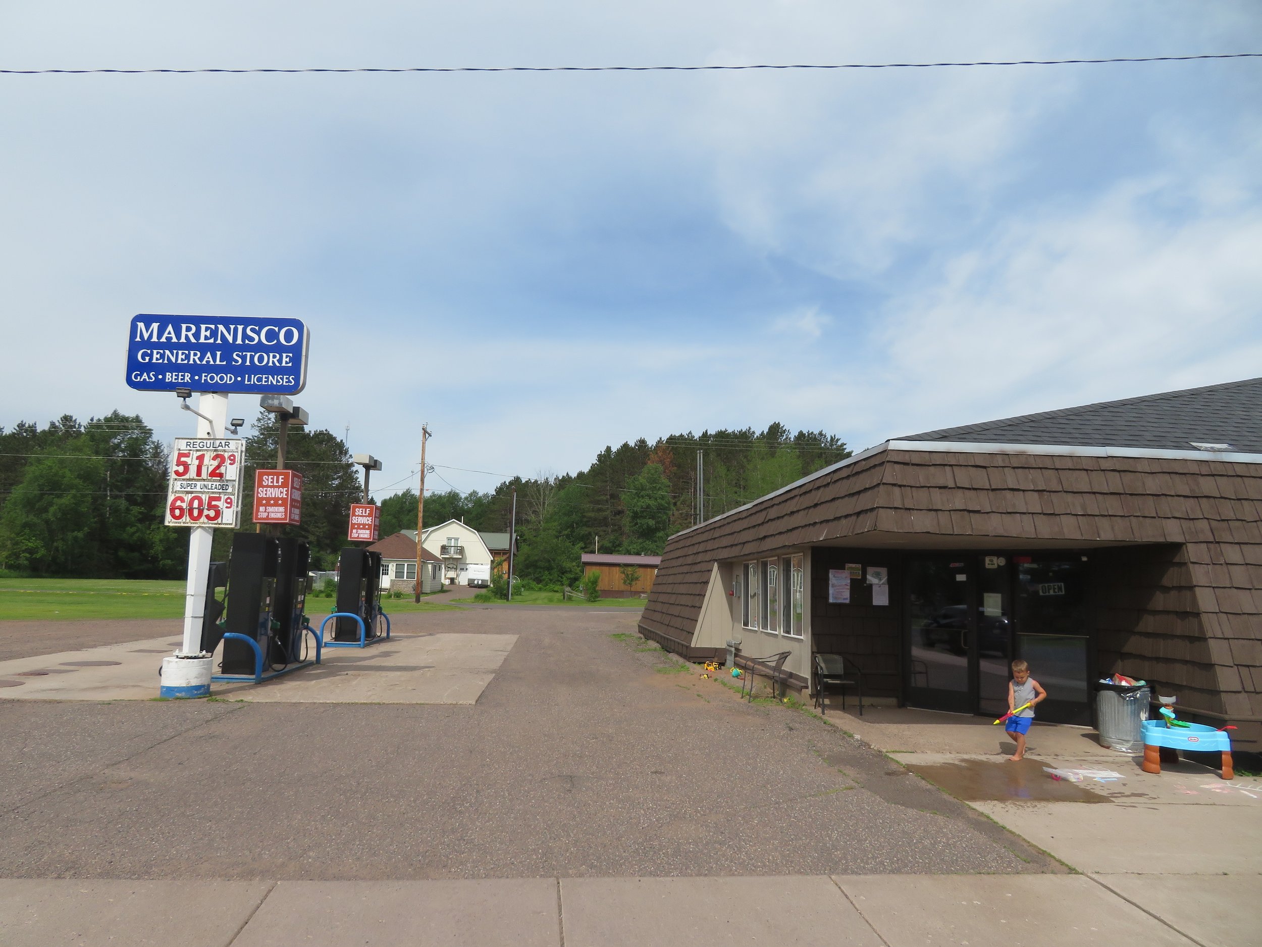
We planned a couple of stops along the way. First and foremost, we wanted to drive through the tiny town of Marenisco, birthplace of David’s mom, Rebecca Jane Lount in 1917. We also wanted to see the World’s Largest Indian, a giant Hiawatha statue, in Ironwood. An exciting day awaited us, for sure.
We drove through heavily forested areas of evergreen and birch approaching the ‘mountains’ of the Gogebic Range. Deer and wild turkeys crossed our path. It’s a rugged area. Ironwood receives about 200” of snow annually and hence skiing and winter sports are popular. As we saw the signs for ski resorts and snowmobile trails, we realized this was a summer-only destination for us.

About a 1/2 mile off US-2, we came to Marenisco. It’s a tiny place with a couple of little restaurants and a bar or two. The houses were small and a bit on the tired side. We saw mostly old folks picking up their mail at the little town post office. We drove around for a bit. It didn’t take long. It looked as if you’d go to Earla’s for breakfast, coffee and morning gossip. If you wanted an evening venue, you’d walk on over to Two Fat Guys for a brewski and a pasty… or a steak or a burger. The General Store would have anything else you’d need until you made the shopping trip to Ironwood. We had questions for David’s mom about growing up here. What was winter like? How did they get around in the winter? Where exactly did they live in town? Was it a one-room schoolhouse? So many questions and they’ll all remain unanswered. We should have asked them when she was here to answer them for us.

Finding Hiawatha in Ironwood was no easy task. It seemed to us if you had the World’s Tallest Indian statue in your town, you’d advertise it, but we saw nary a sign and directions on Atlas Obscura were vague… obscure, actually. We finally found him standing proudly on a hill overlooking the town at the Miner’s Memorial Heritage Park. A sign indicated that ‘Hiawatha’ was 52’ tall, weighed 18,000 lbs. and was constructed of all fiberglass by Gordon Display, Inc. He was erected in 1964 by the Ironwood Chamber of Commerce.

Ironwood is a mining town and as its name implies, iron ore has been mined here in the Gogebic Range since the mid-1800s, but nowadays most mines have closed down. In 1906, the Norrie Mine here was considered the greatest iron mine in the world. Reminders of the past and tributes to the miners are everywhere.

Crossing over the Wisconsin state line, we passed by a giant corkscrew which required a u-turn and a second look. We figured there’d be a giant bottle of wine around somewhere, but we never found it.

Thinking we might not get a campsite for the night, we decided to secure one before heading into Duluth. The Wanoka Campground in Chequamegon National Forest had several open sites with basic services for $15/night ($7.50 for card holders). We splurged on campsite #6, left our camp chairs to mark the site as taken, then continued on US-2 to Duluth. We finally arrived at the Thompson Hill Rest Area which marked our turnaround spot. After a quick pit stop, we turned around and headed on US-2 East, passing up an opportunity to visit the accordion museum in Superior. Maybe next time.
Back at the campsite, we took a walk down to the little Lake Wanoka. It was serene and peaceful. A couple of anglers were fishing. Birds were chirping. The mosquitoes were beginning their evening attack. Thunder was rolling and we headed back to the campsite.

Eastern red columbine were in bloom and white admiral butterflies were flitting around, unbothered by either the thunder or the mosquitoes. We, on the other hand, bothered by both, retreated inside Blanche for the evening.


Day 26 - It poured all night long and sometime during the night, David got sick. Getting sick is never pleasant. Getting sick inside a tiny van is the pits, especially when your partner is known to gag when she brushes her own teeth. By morning, several trips in the rain to the vault toilet up the road, he was still feeling wonky, but was able to sleep a bit. A road trip, however, wasn’t quite in the cards just yet. I made a reservation at a nearby hotel, asked for an early check-in and we hung out at the campsite until he felt well enough to endure a ride. The hotel was only a few miles away in Ashland and once we got there, he climbed into bed and was out like a light for hours. By evening, he was feeling better. No photos!
Day 27 - By the next morning, though not 100%, David had pretty much recovered and after a hot shower and a hot breakfast, we were on the road again, but decided we’d take it easy. It was laundry day and I managed a couple of loads at the local laundromat while David did a supply and victual run at the local Walmart.
Yesterday, the temperature had hovered in the mid-80s and was humid. Today, the temperature had plummeted and the high was in the mid-60s. Once on the road, we finally left US-2 and headed north and east to rejoin the Lake Superior Circle Tour route.
The route took us along the southern coast of Lake Superior. Sometimes it would hug the coast, then veer away inland a bit and then we’d glimpse the lake again. It was cold, windy and raw and the white-capped waves were more akin to the ocean than a lake.

We checked into the Van Riper State Park in early afternoon. The weather, though still cool, had mostly cleared and offered glimpses of the sun every so often. Pleasant strains of music filled the air. Folks were playing corn hole and laughing. Kids raced around on their bicycles, giggling and whooping as they passed. It was a pleasant evening scene and we sat out for a bit and relaxed. David was, fortunately, feeling pretty much back to normal.
Next time, we’ll complete the Lake Superior Circle Tour and head into Canada again. But first, you’re bound to enjoy your visits to Yooperland, Lakenenland and the Shipwreck Museum.