

Cycling in Ohio - Zoar Valley Trail
/Zoar Valley Trail - Ohio Route 800 to Massillon - 32 miles RT
There are lengthy gaps in the GART in this area which rely heavily on roads and highways. We opted to avoid these and parked at lovely Fort Laurens State Park to ride. A bit of trivia… Fort Laurens is the only American Revolutionary War fort in Ohio.
Between Route 800 and Fort Laurens, the Zoar Valley Trail follows the towpath of the Ohio-Erie Canal (O&E). Completed in 1832 (that’s before the C&O Canal) and operated until a 1913 flood destroyed major portions of it, the Separatists in Zoar brought part of the canal to their town by constructing a slackwater dam and guard lock in 1832. Canal boats could dock next to their woolen mill and other industrial buildings (now gone) and load up conveniently. The Society of Separatists of Zoar community, subsequently referred to as Zoarites, was settled in 1817 by German religious dissenters who had left southeastern Germany to escape persecution for their religious beliefs. A common historical theme.

According to the NPS website, “The Ohio & Erie Canalway is a National Heritage Area – designated by Congress – to help preserve and celebrate the rails, trails, landscapes, towns and sites that grew up along the first 110 miles of the canal that helped Ohio and our nation grow.”
When Ohio became a state in 1803, it was sparsely settled and had no way to move goods to or from the communities there. Connecting Lake Erie to the Ohio River and points east opened up the area to commerce as part of the USA’s westward expansion effort. Like the C&O, the ‘ditch’ was dug manually. Workers were initially paid $0.30 per day and offered a jigger of whiskey. The labor rates improved later to $15/month when good help was hard to find. Sound familiar?
Again, like the C&O Canal, several canal locks were used to raise and lower the canal boats as they traveled the canal at 3 mph, laden with up to 10 tons of goods. Looking at the depths of some of the canals and trying to imagine the work necessary to dig these canals was unfathomable.

It was only ~6 miles to Route 800. The trail was rustic and narrow, reminding us very much of the C&O Towpath we’d already ridden.

After having ridden several paved trails over the past few days, the towpath trail was quite welcome. As wonderful and smooth as the paved trails are to negotiate, it can get quite boring after awhile. Maneuvering on the towpath was more of a challenge and, the wildlife was definitely more interesting.

Just how many turtles can fit on a log? Quite a few, it appears, especially if you don’t mind stepping on your neighbor’s head.

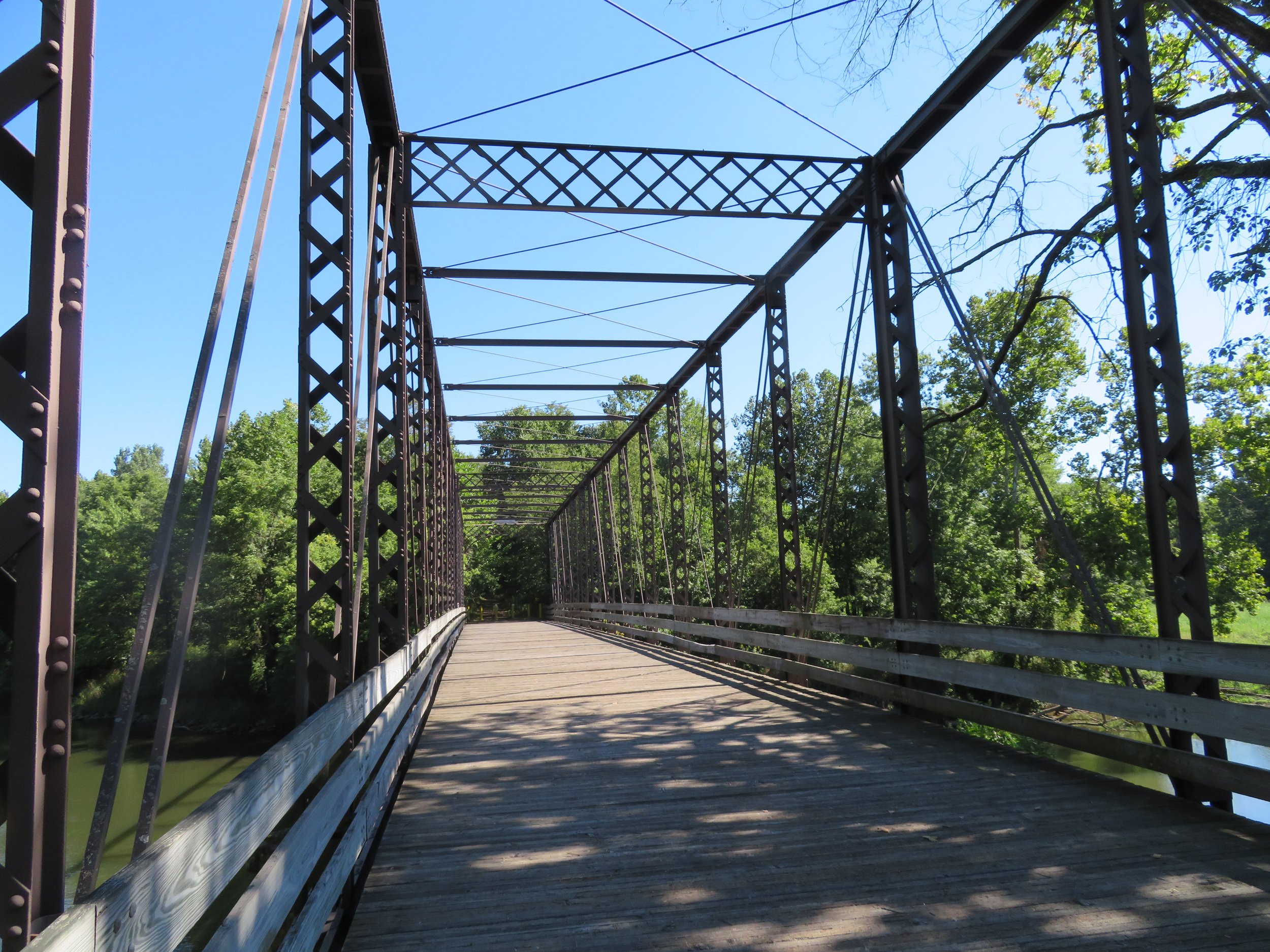
The Old Route 82 Bridge over the Tuscarawas River was erected in 1883 and has been repurposed as part of the North National Scenic Trail, the longest in the National Trails System, stretching 4,800 miles across eight states from North Dakota to Vermont. Food for thought! We climbed up on the trestle to take a look.

One section of the trail was a boardwalk that jutted out around a concrete structure in the canal. We had to walk the bikes, but it was so narrow, we’re glad we did because had we met up with someone, it would have been a very tight fit. Glad we didn’t have our horses with us.

At Ohio Highway 800, we reversed direction, took a quick break at Fort Laurens, and headed off towards Massillon at the other end of our designated route for the day.
This part of the trail was crushed limestone and fine riding with enough roadside diversions to keep us entertained. We stopped to admire cabooses on display at one road intersection.

What is that delicious smell? The aroma of fresh baking bread caught us by surprise. We rounded the corner and there was Nickles Bakery. Wish they were giving out free samples. Also wish we had a ‘smell’ app to share with you.

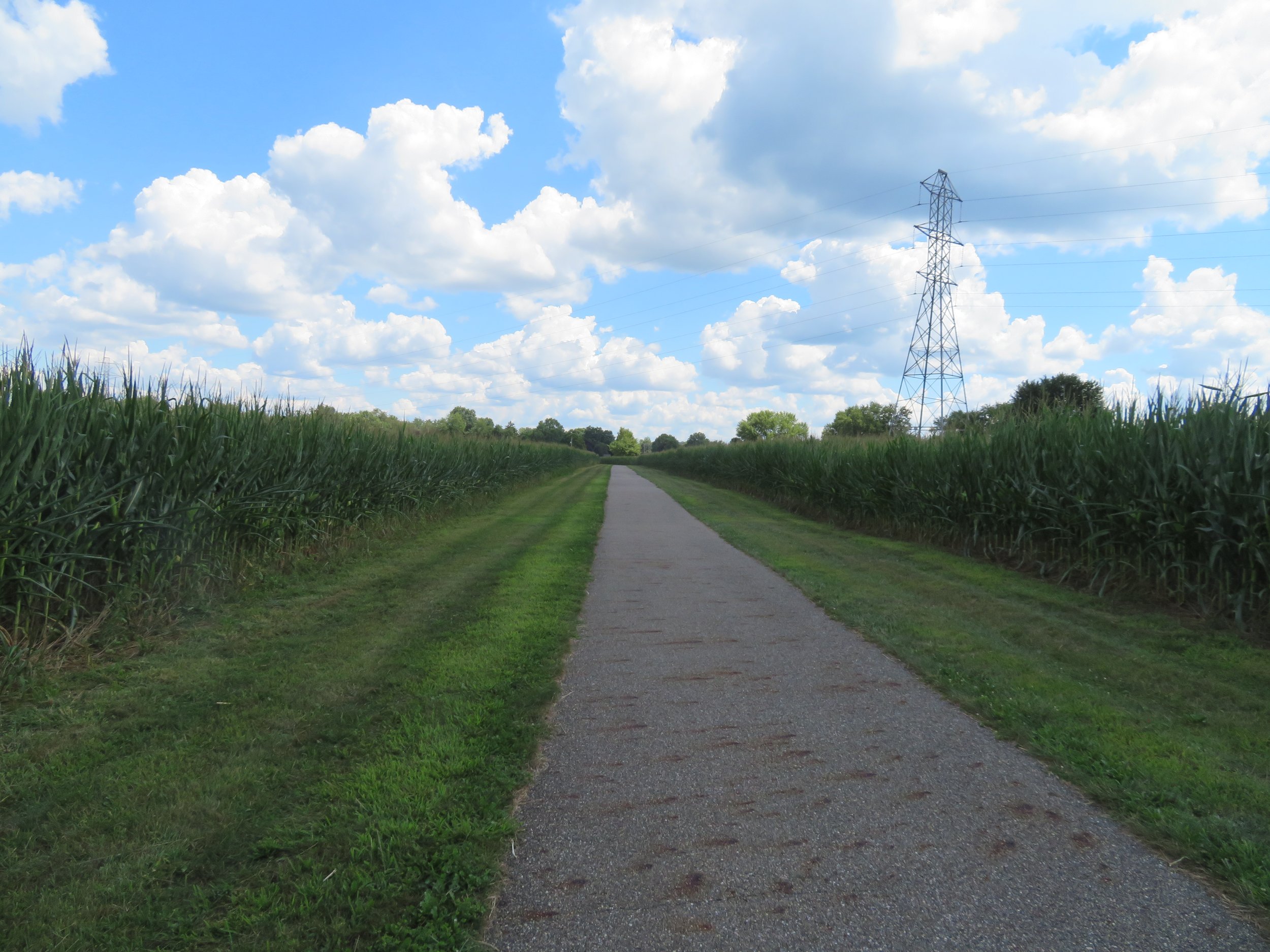
There was a short on-road section on quiet side roads through the town of Bolivar and then we were riding between corn rows and past farms. Riding midst the corn reminded us both of our trek to visit Buddy Holly’s plane crash site in an Iowa cornfield a couple of years ago. There were lots of informational kiosks and signs en route to provide local and historical color for our ride.

John Glenn, astronaut and US Senator, was born in Cambridge, OH. We passed through John Glenn Grove honoring its native son.


After completing our 32 mile round trip, we treated ourselves to lunch at the Towpath Tavern in downtown Bolivar, not far from where we had parked. There were tables, but we opted to belly up to the bar and ordered one of the tavern specials and a draft beer. The place was like Cheers… welcoming, lots of locals and everyone chatting with everyone. A very pleasant lunch!

Trail to Nowhere - 15.7 RT
The next morning, we parked at a Massillon trailhead to pick up the trail. We rode only about 3 miles before we encountered a detour which closed a section of the trail.


No problem. We rode back to Blanche, loaded up and headed to the Lake Avenue Trailhead where the trail resumed. We checked out the other end of the detour in case there was a mile or so to ride, but no, it was right there.

We rode nearly 5 miles before David determined we weren’t on the correct trail. Though the trail was pleasant enough, it just wasn’t the trail we were supposed to be riding. Bummer! We turned around and headed back to the trailhead. Evidently, the trailhead for the Sippo Valley Trail was somewhere along the detoured section. We found an alternate access route, but decided it was too late to start all over again. Back at the trailhead, we checked out Ernie’s Bike Shop, then headed next door to the Blue Heron Cafe for lunch.

A short day, but who’s counting? We’ll figure out where to access the correct trail and for sure, it’ll still be there tomorrow. And we did and it was.
Keep your mind in pedaling mode… more Ohio trail cycling next time. Hope you’re enjoying it as much as we are.