

Another Detour - Haines, Alaska
/We were back on the Alaska Highway in Tok (rhymes with poke), Alaska and the obvious thing to do was to either head north to Fairbanks or west to Anchorage, but… there’s always a ‘but’. I’d recently read a brochure about Haines, Alaska… another pene-exclave community about 438 miles south… way out of the way, BUT it was on the Lynn Canal (the longest and deepest fjord in North America), it looked like a very picturesque community AND we could possibly catch an express catamaran sightseeing trip to Juneau from there. Why not?

Our friend, Gitti from New York, recently commented that she liked how we ‘bumblebee’d’ around. I love the expression. With her permission, I plan to use it in the future. It’s a perfect description of how we travel… flitting from one blooming place to another. And, yes, we were bumblebeeing again… this time to Haines.
It was late morning as we exited the Taylor Highway, jumped onto the Alaska Highway once again and entered Tok. Tok isn’t a large town, but it’s a major junction for heading anywhere else in Alaska. The Alaska Highway is Tok”s Main Street. There are RV parks and restaurants, a couple of gas stations, a grocery and a hardware store. The Visitor Center is large and well-stocked with brochures and that was our first stop.

We had a late breakfast at Fast Eddie’s, then gassed up, stopped at the Three Bear Grocery to replenish the larder and headed south on the Alaska Highway to Haines Junction. Gas was $4.19/gallon, by the way, and after what we’ve been paying in Canada, we called that a bargain. As far as visiting Tok, we figured we’d give it a better look-see when we headed back this way in a week or so.
After all the errands and stops, it was late afternoon by the time we stopped at the ranger-recommended Deadman Lake to camp for the night. Part of the Tetlin National Wildlife Refuge, the campsite was free… donations appreciated. ‘Free’ campgrounds always cost us more money than regular pay campsites, it seems. Our campsite (#8) was gorgeous… right on the lake with ducks and loons swimming by (except when I had my camera handy). Small red squirrels were all over the campground and were particularly amusing to watch and hams for the camera.

A 1/4 mile interpretive nature trail along a boardwalk was informative.

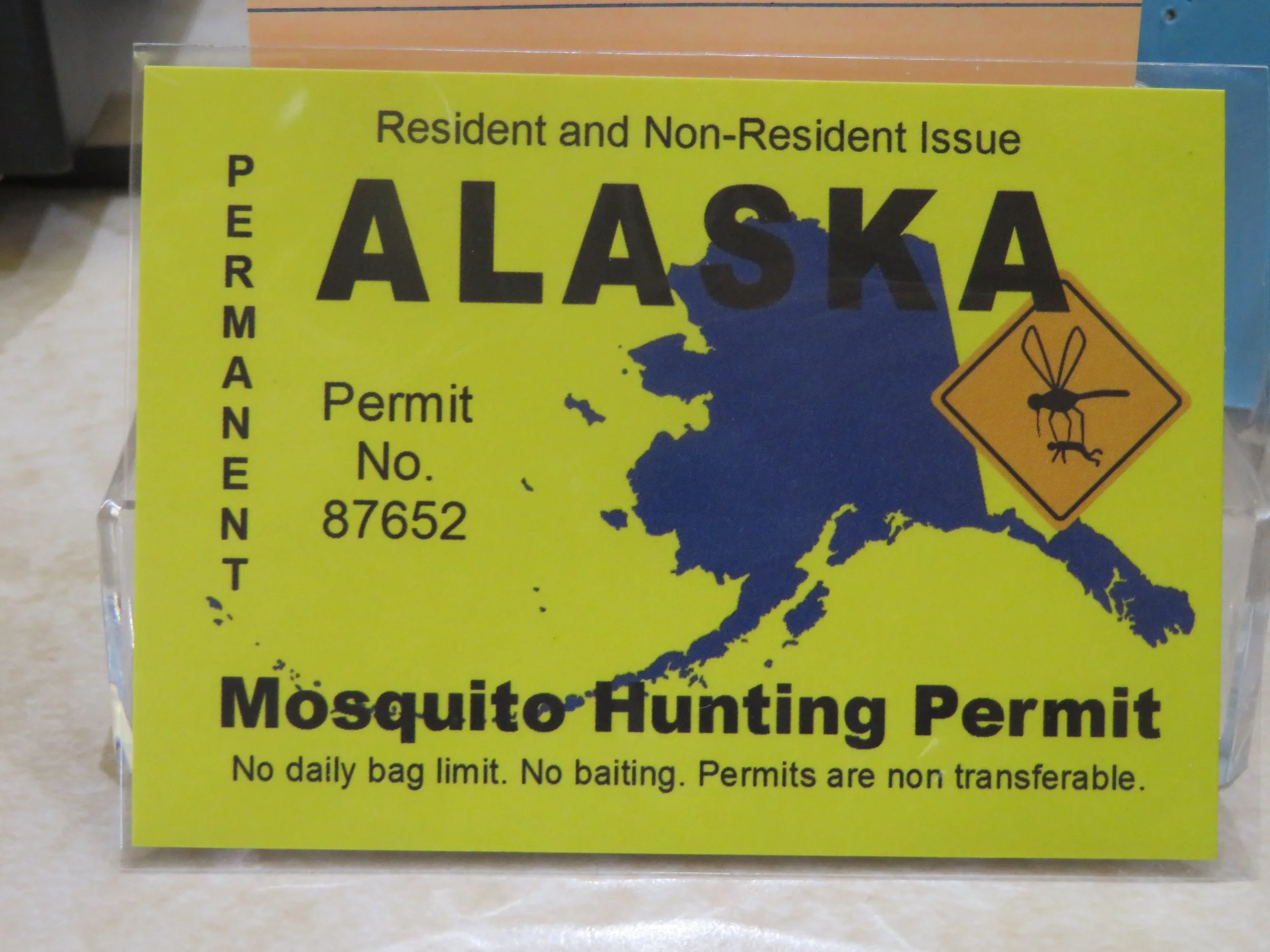
Everything about the park was wonderful except the mosquitoes and they were fierce. Luckily, while at the Tok Visitor Center, we picked up our mosquito licenses and with a ‘no bag limit’, we swatted rather vigorously and determinedly. We’re practicing quick get-intos and get-out-ofs Blanche to minimize swat time.
We were up early and on the road. The route to Haines would take us along the Alaska Highway to Haines Junction, Yukon Territory and then into an extreme northwest bit of British Columbia before entering back into the USA at Haines. In the course of 45 miles, we will have traveled through three different time zones, two provinces and two countries.
As usual for us, nothing is fast. We dawdled at Seaton Recreation Area which used to be a 1940s roadhouse stop for travelers along the Alaska Highway. Now it’s just a large, off-the-road rest area with trails and a picnic area. We took a quick walk around a beaver pond. There were lots of dragonflies, but evidently not enough to take care of the mozzie population because they were thick and subsequently the walk was significantly quicker than intended.

There are two seasons in Alaska… winter and road repair. The roads were rough with lots of potholes, ruts and repairs and maintenance in progress. We’d go 3-4 miles, then queue up in a long line and wait 15-20 minutes for a pilot truck to escort us a couple of miles up the road. Then drive another 4-5 miles and repeat the process.

We finally made it to the Yukon border, passed through without delay and hoped the Canadians weren’t doing as much road work as the Americans. Hope, however, did not prevail. Another 20 miles up the road and we were driving on gravel with signs warning us of ‘extreme dust’. The same process as we’d just experienced on US side of the Alaska Highway was happening on the Canadian side. Stop, wait 10-15 minutes for a pilot car, drive 2-1/2 miles at 15 mph over rough surfaces then back to pavement… repeat… repeat. Worse, the dust required us to drag out the tarp and cover up the bedding. Deja vu, all over again.
We saw our first bald eagle of the trip at a little pond along the roadside.

Nearby, we observed a pair of nesting trumpeter swans. We’d learned that swans prefer to nest in eagle territory for protection. Since eagles are so territorial and fierce, if a swan ends up sacrificing an egg or young one to an eagle, the rest will be protected from other predators by the same eagles. Interesting trade-off!

Along the same stretch, we spotted a grizzly eating flowers along the side of the road.

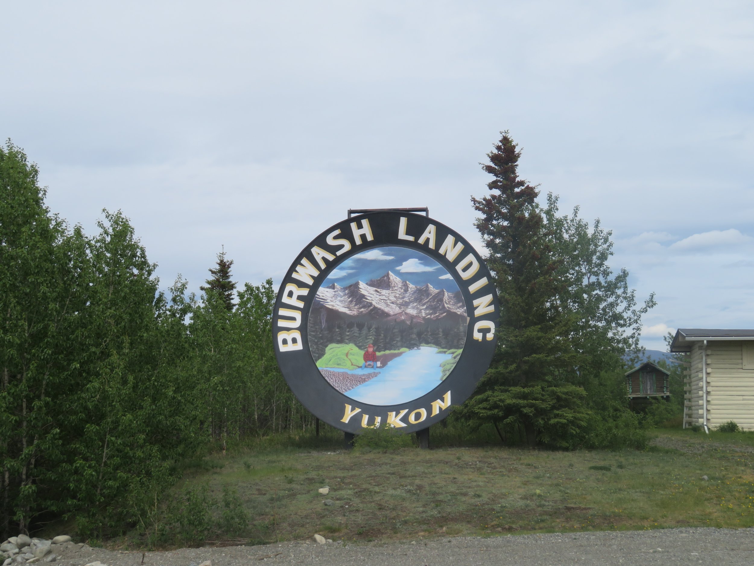
A giant goldpan welcomed us to Burwash Landing. We took a photo on the fly.
We were thrilled when we finally reached Haines Junction, gassed up and took the the turn-off for the Haines Highway (Alaska-7). The Haines Junction 24’ Village Monument sculpture known locally as ‘the animal cupcake’ or ‘the muffin’ was a definite photo opp.

The 229-mile drive from Deadman Lake Campground to Haines Junction had taken us over 10 hours. Even for us slow travelers, that’s pretty slow. We found a campsite at Kathleen Lake about 16 miles down the Haines Highway and called it a day.
We hit the road early after a rough night with mosquitoes. Mosquito licenses notwithstanding, the pesky critters plagued us with constant buzzing and biting, driving us crazy. We thought Blanche was pretty well mosquito-proofed…the mosquitoes scoffed at our arrogance. They got in when we did and then hid till the lights went out to start their bloody raids. Even with a ‘no bag limit’, we lost the battle.
The Haines Highway was in good condition, comparatively speaking. It had some rough spots, but no major delays. A National Scenic Byway, this highway offers an absolutely stunning drive. From glaciers, to majestic snow-covered mountains, to lush forests, to desert-like plains, the road wends its way 132 miles south to the little, isolated community of Haines, Alaska.
The vistas along this highway are gob-smacking spectacular. These are some of the most majestic and beautiful mountain views we’ve ever seen. Snowy peaks, forest greens, lakes and ponds all combine to provide eye candy for natural view gluttons. Every mile we drove offered more ‘oh-my’ moments.

Neon fuchsia boreal sweetvetch, white locoweed, purple lupine and yellow dandelions provided a kaleidoscope of color along the roadside, sometimes all the way up the road bankings… an unlikely quartet of weeds to be so absolutely beautiful.

Lush, thick, emerald-green spruce and aspen climb along the mountainsides looking so perfect, it appears they’ve been sculpted by a master gardener. The sky was overcast and gray, but patches of blue sky in the distance promised clearing and sunshine.
Zebra-striped peaks of the St. Elias Mountains, so dazzling and mesmerizing, teased our eyes. Mother Nature’s ‘trompe d’oeil’ … an optical illusion akin to line drawings by M.C. Escher. Snow remained in the saddles and grasped the ravines and clefts.

The highway was in amazingly good condition and much appreciated after yesterday’s travails. Rest areas, turnouts and campgrounds were frequent all along the route. A scrawny red fox trotted alongside us with nary a concern until we stopped, then he darted off.

Finally, U.S. Customs and we were back in the USA. A “Welcome to Alaska and the Valley of the Eagles” sign greeted us… 40 more miles to Haines.

Next time, we’re going to talk about Alaska’s state bird, the mosquito. then we’ll explore the little town of Haines. There’s lots to see. Join us!