Chesapeake -Norfolk to Mobjack Bay

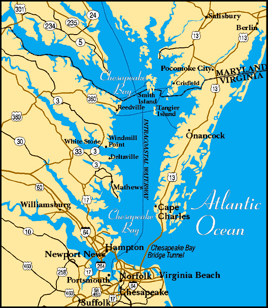
Day 2 – 32nm (passage total: 49 nm) mobjack bay map

We spent a relatively calm night in the general anchorage off the loading docks in Norfolk. Huge Hapag Lloyd container ships were a bit noisy in their loading activities, but otherwise no worries, no problems. The plan was to head north to Mobjack Bay on the East River. We returned to the main channel, passing Fort Wool to starboard and the Old Port Comfort Lighthouse to port as we motored into Chesapeake Bay.

fort wool

old comfort port lite

The day was lovely and the light breeze was wonderfully refreshing. We motored for a few hours, but by mid-day we were actually able to sail for awhile and enjoyed the quiet and calm of the bay. The lighthouse at Thimble Shoal is quite a different style than most lighthouses we see, but is the typical style lighthouse for the Chesapeake.

thimble shoals lite chesapeake

We arrived in Mobjack Bay around 3 pm and found a perfect a little anchorage just out of the channel inside the entrance to the East River.

mobjack bay anchorage

David felt that Cups' speed had been sluggish during the day and jumped in the water to have a look at the prop. The visibility was less than a foot as he scraped a fine collection of barnacles off the propeller. He chastised himself for not doing this at the AYB dock, but better late than never.

Yesterday's coolant hose replacement kept the engine temp down, but it was still running higher than normal. Once the engine cooled down, the guys took a look at the impeller. It was due for a change. They decided to let it wait till morning. We enjoyed cocktails in the cool of the cockpit, ate some dinner, played a few games of gin (David won, but we're sure he was cheating) and then reveled in the beauty of a full harvest moon over a duckpond calm anchorage.

full moon over the bay

The Blue View - Coast Guard Checklist

Since it’s been quite a while since we sailed in U.S. waters, we thought it would be a good idea to review the US Coast Guard documentation and make sure we were in compliance with all the regulations. I suspect that if we were boarded for a routine safety inspection, they might want to check a few other things besides the expiration dates on our flares. info collage

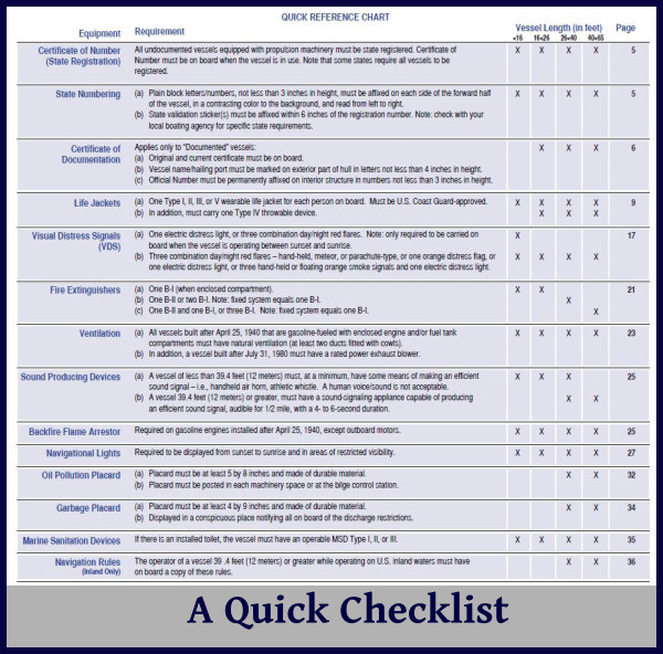
It took only a few minutes of online searching to find a host of documents describing the various guidelines and requirements for pleasure vessels. One particularly helpful document is A Boater’s Guide to the Federal Requirements for Recreational Boats. I found this 45-page pdf document to be quite informative and easy to read. The government writers did a good job of translating the federal code into something that was understandable and almost interesting. I read the entire booklet and found several requirements that were new since we left the U.S. all those years ago – not to mention a number of requirements I had forgotten. It also included a checklist which I found quite useful.
checklist

So, how did we stack up? We met nearly all of the safety requirements – life jackets, fire extinguishers, horns, bells, navigation lights, bilge pumps, etc. One safety issue I had missed was the requirement to cover all battery terminals to prevent a problem should a tool be dropped across them. I fabricated terminal covers from heavy plastic and, using cable ties, attached one to each battery terminal.

battery terminal covers

We also met most of the other requirements, such as a marine sanitation device (a holding tank in our case), and an on-board copy of the navigation rules. (The nav rules are also available digitally on line, in case you need to print them out.) We did, however, find a number of issues that might have been grounds for a citation had we been inspected.) To make sure we were in compliance with everything on the list, we spent the last two days before departing Chesapeake, VA, scurrying around making sure we found everything we needed.

For example, we didn’t have Cup’s documentation number permanently affixed in a conspicuous location inside the boat, with numbers that are at least 3” in height. We do have our doc number painted onto the interior of the hull under the aft bunk, but this is hardly a conspicuous location. We found stick-on letters at the local hardware store and stuck-em on, so we should now meet this requirement.

a conspicuous location

We also did not have a copy of the MARPOL regulations regarding the disposal of garbage and waste overboard. This should be in the form of a permanent placard, affixed in a conspicuous location, so that everybody on board will be aware that it is illegal to dispose of plastics, oil and garbage in U.S. waters. We found these, free of charge by the way, at the local West Marine. While we were there, we picked up a very nice placard with a written trash disposal plan to replace our rather old, weathered version – also free of charge.

anchor ball

Finally, we did not have an anchor ball. When we are anchored at night, we are required to have a white anchor light, visible from all directions. This is not only a requirement, it’s also common sense – we want to make sure other vessels see us at night. More than once, we’ve been run into by fishing boats while anchored, even while our anchor light was shining brightly. Thus, we usually augment our anchor light with our spreader lights, just to make sure we can be seen. When anchored during the day, we are required to display forward, where it can best be seen from all directions, a black ball. In our 16 years of cruising, I doubt I have seen more than half a dozen sailboats that actually do this, but it is a federal (and international) navigation requirement, and we should make an effort to comply. None of the local chandleries had a black ball in stock, so we decided to make our own, and went on a search for something that would work. We eventually found two large plastic, round black bowls for 97-cents each in the Halloween section of a local Walmart. We drilled holes in the top and bottom and attached a small line, then taped them together - using black duct tape, of course. It works quite nicely and should last until, if and when we decide we need a more permanent solution.

anchor ball fabrication

BTW, the volunteers with the U.S. Coast Guard Auxiliary will, at no charge, perform a courtesy safety and compliance check on your vessel. It is informational only - they do not issue citations nor report you for safety violations. If you pass their inspection, the vessel will be issued a signed statement to that effect, as well as a decal that can be affixed to the boat. If we stop anywhere long enough to schedule an inspection, we plan to have it done.
10 Fun Facts About Chesapeake Bay

As we start exploring the Chesapeake, I thought I'd share some facts and trivia with you. chesapeake map

  1. Chesapeake Bay is the largest estuary in the USA. An “estuary” is an area of brackish water where fresh water, from rivers and streams, meet with the ocean. Chesapeake Bay and its network of streams, creeks, and rivers, encompasses over 64,000 square miles throughout Pennsylvania, Maryland, New York, Virginia, Delaware, and Washington DC. According to internet sources, it is the third largest estuary in the world. The St. Lawrence River is the largest and the Rio de la Plata in Uruguay/Argentina is number two.
  2. According to NOAA, “more than 250 fish species use the Bay and tributaries for some portion of their life cycles, including American and hickory shad, river herring, striped bass, eel, weakfish, bluefish, flounder, oysters, and blue crabs. More than 300 migratory bird species can also be found in the watershed. During the fall, the skies come alive as one million ducks, geese, and swans return to overwinter on the Chesapeake.
  3. The Bay itself is about 200 miles long, stretching from Havre de Grace, Maryland, to Virginia Beach, Virginia. Its width ranges from four miles near Aberdeen, Maryland, to 30 miles near cape Charles, Virginia. The mouth of the Chesapeake Bay is about 12 miles wide between its northern point near Cape Charles, Virginia, and its southern point close to Cape Henry, Virginia. The Bay and its tidal tributaries have 11,684 miles of shoreline—more than the entire U.S. west coast. The Chesapeake Bay watershed has 150 major rivers and streams, but contains more than 100,000 smaller tributaries.
  4. The Bay is surprisingly shallow. Its average depth, including all tidal tributaries, is about 21 feet. A person who is six feet tall could wade through more than 700,000 acres of the Bay and never get his or her hat wet.
  5. The Chesapeake Bay holds more than 18 trillion gallons of water. Approximately 51 billion gallons of water flow into the Bay each day from its freshwater tributaries. The Bay receives about half its water volume from the Atlantic Ocean in the form of saltwater. The other half (freshwater) drains into the Bay from the enormous 64,000-square-mile watershed, the Susquehanna River being the largest tributary, and contributing about 19 million gallons per minute.
  6. The Bay supports more than 3,600 species of plants and animals, including 348 species of finfish, 173 species of shellfish, over 2,700 plant species and more than 16 species of underwater grasses.
  7. During the winter, the Bay supports 87 species of waterbirds. Nearly one million waterfowl winter on the Bay–approximately one-third of the Atlantic coast’s migratory population. The birds stop to feed and rest on the Bay during their annual migration along the Atlantic Migratory Bird Flyway including more than 500,000 Canada geese.
  8. The Bay produces about 500 million pounds of seafood per year. Since 1990, commercial watermen have harvested more than 1.6 billion pounds of blue crabs from the Bay. Data show commercial harvest has experienced a steady decline, and in 2014 hit the lowest level recorded in 25 years: 35 million pounds.10-fun-facts-graphic
  9. The word Chesepiooc is an Algonquian word referring to a village "at a big river." In 2005, Algonquin historian, Blair Rudes, helped dispel the widely-held belief that the name meant “great shellfish bay.”
  10. Historically, there were many different Native American tribes in the region before Europeans arrived, but the dominant group were Algonquin speakers known collectively as the Powhatan tribes. In 1524, Italian Captain Giovanni da Verrazano became the first recorded European to enter the Chesapeake Bay. In 1608, Captain John Smith set off on the first of two voyages where he charted the land and waterways, and later drew an elaborate and remarkably accurate map of the Chesapeake Bay.

And there you have it, more than you'll ever want or need to know about the Chesapeake Bay. Let's get on with the exploring.