

Cycling the C and O Canal Towpath - 2
/
We’re riding the Chesapeake & Ohio Canal Towpath, the 184.5 mile multipurpose, recreational trail from Cumberland, Maryland to Washington, D.C. We are yo-yo’ing along the trail, that is we ride in one direction for 15 or so miles, then ride back to our starting point where Blanche, our van, is waiting. We average about 30 miles/day round trip, some days less, some days more. Though it’s a slow way of riding the trail, we do, as our nephew Erik puts it, get to see the signs from both sides. When we’re done, we’ll have ridden the trail twice. It’s an awesome way to travel.
Day 3 - The Paw Paw Tunnel - 12 miles RT
It was a quiet night at the park/campground, but in the morning, construction workers on a nearby highway bridge arrived very early and parked all around us. The bridge construction has created a detour on the towpath which was a bit confusing to follow. After one false start, we retraced our route, and finally found our way to the towpath once again. We found where we left off yesterday at MP 159 about 4 miles to the west, touched ‘GO’, turned around and headed up to the entrance of the Paw Paw Tunnel.

They’re also working on the towpath at the east end of the tunnel and the towpath is closed for a mile or so due to landslides and rockfall. The alternative is a detour called the Tunnel Hill Trail, a 2.1 mile long, very rough, steep, narrow, mostly unrideable trail, that goes over the top of ridge above the tunnel.

Interestingly, though this route has been designated the ‘towpath detour’, officially bicycles have not been allowed.
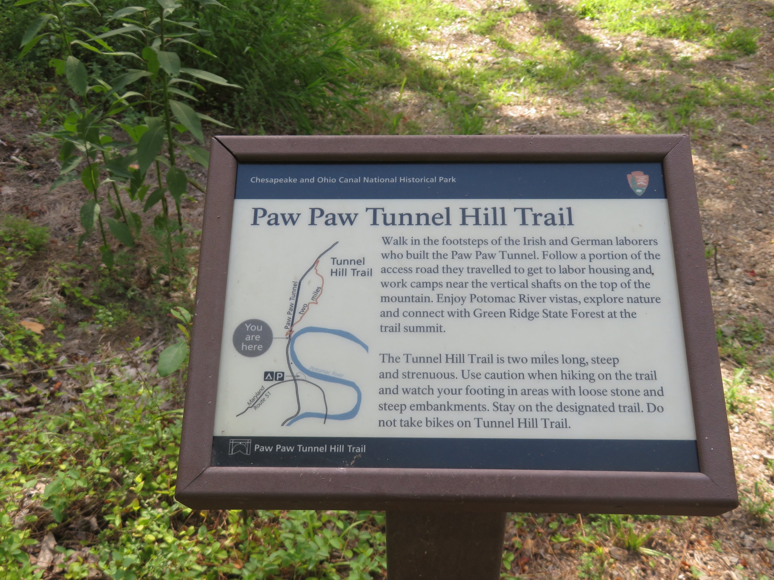
The tunnel itself is ‘open to visitation’, so we walked in and it definitely looked, felt, and smelled just like a tunnel.

According to the NPS brochure (and I paraphrase), the Paw Paw Tunnel is a 3,118’ canal tunnel carved by immigrant workers and the largest structure on the C&O Canal. Built to bypass the Paw Paw Bends, a 6-mile stretch of the Potomac with several horseshoe bends, the original estimate was a 2-year project costing $33,500 to complete. Construction began in 1836 and 14 years later in 1850, it was completed at a cost of $600,000. The name comes from the the pawpaw trees that grow in the area. A bit of tunnel trivia… the inside of the tunnel is lined with six million bricks. You can see them as well as the ‘light at the end of the tunnel’ in the photo below. You can also see the canal which runs along side of the towpath.

Being the wimp that I am, I declined going over the path. My left knee was still painful from my fall and hauling the bike up, over, and then down the steep, rugged trail was just not a positive prospect. David, being more adventuresome than I, decided to ride or hike-a-bike to the top of the ridge and then return.


While waiting for him I sat and chatted with 70-year-old Gilbert, a construction worker whose job it was to monitor the water levels in the canal and pump it out when necessary. Additionally, he acted as a communication relay via 2-way radio between the trail workers on the east side of the tunnel who were without cell phone signal. Mostly, he said, he sat and chatted with hikers and bikers who were traversing the C&O Canal Towpath. Chatting with Gilbert was interesting. He answered several of my questions and supplied colorful anecdotes on other tunnel construction and renovation work he’d done during his long career. By the way, Gilbert and a network of friends can provide transportation from the tunnel entrance to the other side of the tunnel path in Little Orleans for a fee, thus eliminating the need to traverse the Tunnel Hill Trail. We have contact information if you need it.

David returned and reported that though the trail was indeed steep and rough, it was doable although it would have probably been a challenge for me and my knee. We chatted a bit longer with Gilbert and then headed back down the trail to Blanche. We loaded up the bikes and headed to Harper’s Ferry with a recon of the trail route along the way and lunch at Buddy Lou’s in Hancock.

A Layday in Harper’s Ferry, West Virginia - No Mileage
As I’ve noted in the past, we hate making reservations, but sometimes it’s a necessity. We’d made reservations for Harper’s Ferry a week before because of a dearth of accommodations and high prices in the area on weekends. Well, due to weather and my knee, our schedule had changed. Unfortunately, the reservation was non-cancellable, non-refundable and $$$. Hence, we decided that a layday in Harper’s Ferry would be great idea.
We stayed in the Friendship Suite of the historic 1820 Town’s Inn, a 3-story stone building, set up on a hill one short flight up from the street. That’s the Friendship Suite with the double doors on the lower right.
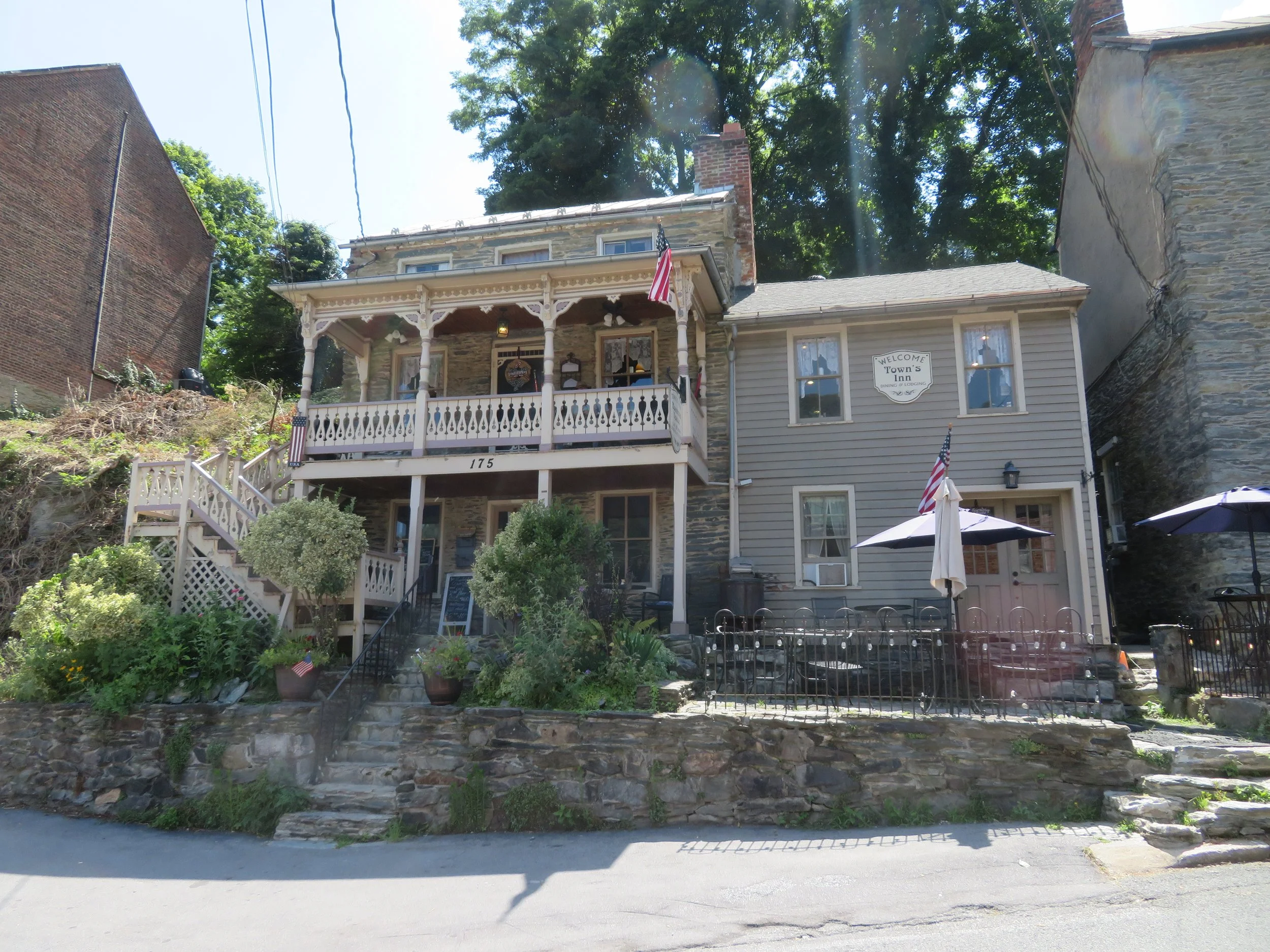
It was rustic, a bit musty with its interior rock walls and low ceilings and a bit dark, but charming in its own historic way.

Parking was at the train station a couple steep flights of stairs down to the lower town’s main street. Harper’s Ferry is all hills in case you haven’t figured that out. The stairs were slow-going for me with my bum knee, but we managed and were rewarded with cold draft beers at the Rabbit Hole, just across the street from our lodging.

We slept in in the morning. David dashed across the street for coffee as soon as the cafe opened. Checkout was at 11am. David lugged the luggage back down to Blanche and I hobbled down the stairs to the lower town. Walking was not much of a problem for me, just stairs, so we walked across the Potomac on the pedestrian bridge. The only way to get bicycles across the river here is to lug them up three steep flights of metal stairs and walk them across the pedestrian bridge. David figured out we could do this. I, on the other hand, was skeptical, but I’d work with his plan. After a most pleasant and relaxing day, we headed to Hancock, Maryland for the night, ready to resume our cycling the next morning.
Day 4 - Little Orleans to Paw Paw Tunnel East End Detour - 32 miles RT
Little Orleans is the closest road access point to the east end of the Paw Paw Tunnel. We left Hancock early and drove a most circuitous backroad route to access the towpath parking lot, unloaded and headed out on the trail. Paralleling the towpath is the Western Maryland Rail-Trail (WMT), all paved and smooth. We, however, stuck to the towpath, though the WMT was oh so tempting.
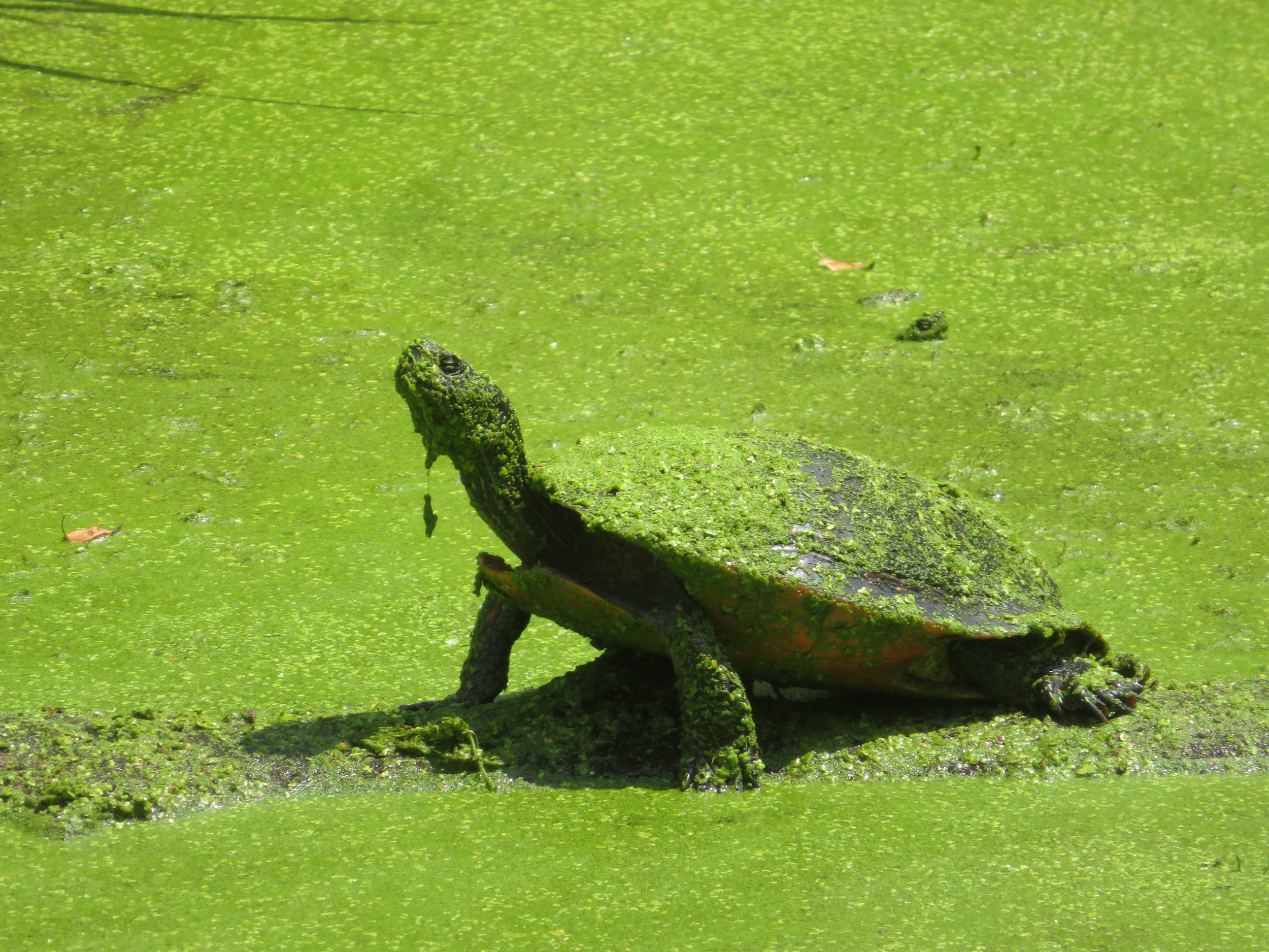
The towpath trail here was very bumpy with exposed tree roots, rocks and potholes. The trail was more like an old country cart road. Two narrow, well-worn ruts sufficed as our path with tall grass growing up between them. We passed by the remains of several old locks and the canal was mostly overgrown with dense foliage. Luckily, most of the puddles and mud holes had dried up, but heavy rain was in the forecast. It was hot, hot, hot and humid… 96F with 50% humidity. It was cool enough riding, but when we stopped, it was stifling.

We saw very few other bikers and hikers, but the wildlife was plentiful… deer, wild turkeys, rabbits, squirrels, and lots of birds. Check out the creature from the green lagoon.
We rode as far as the Paw Paw Tunnel detour, turned around and retraced our route.

Bill’s Place is strategically located near the parking lot and though tempting, it was just a little too early in the day for a beer and lunch. It was also too hot and humid for camping, so we opted to stay in a small hotel in Hancock.

C &O Bicycle in Hancock is located in the block between the towpath and the WMRT. We stopped in to check it out and it’s awesome. They offer camping, showers, porta-potties, lots of biking gear, souvenirs, repairs and a most knowledgeable and friendly staff. I ended up buying a Cloud 9 gel seat cover (for which my butt thanked me) and we both bought C&O Towpath t-shirts.

Day 5 - Hancock to Little Orleans - 31 miles RT
There was a violent thunder and lightning storm during the night with heavy rain and hail and extremely high winds. The morning, however, dawned sunny. We feared huge puddles and mud on the trail and were surprised that the trail was mostly dry. The storm, however, had downed trees and huge limbs and branches littered the path. We left from Hancock and spent more time dismounted clearing the path of debris so we could get through than we did riding.

Across the canal, we observed the remains of the Round Top Cement Mill which operated from 1838 to 1903, providing high quality limestone from the abundance of natural ingredients in the area. According to the info sign, Round Top provided cement for the construction of the Capitol Building, the Washington Monument and much of the western end of the canal.


We worked for every mile of trail we progressed. It never seemed to get easier. Finding a path over, under, around or through the trees that blocked our way was a challenge. What would usually have taken us 2-1/2 hours to complete ended up being closer to 6 hours.


We rode back on the Western Maryland Rail-Trail (WMRT) which runs parallel to the towpath thinking it would be better and faster since it was wider and paved. It would have been faster if not for the fact that it too had just as many trees and branches occluding the path.

By the time we got back to Hancock it was 99F with a heat index of 106F. We were hot, sweaty and exhausted. We learned that the electricity was out in more than half of the town with an anticipated return by 5pm the next day! Fortunately, our hotel was in the half with electric power and returning to the cool A/C in our room was heaven. After a shower, we shared cold beers and made tacos in our room, watched a little tube… and took a long, well-deserved rest.
We’d planned to leave Blanche here in Hancock and ride straight through to Point of Rocks, reclaiming Blanche in a few days. The weather forecast, however, was very iffy, trailside accommodations were a bit sketchy and we were concerned we’d be stranded if the weather was as severe as was forecast. We opted to be prudent and continue to yo-yo each segment of towpath. It was slower and certainly not as efficient, but it did allow us to modify our plans and arrangements at a moment’s notice..
Day 6 - Hancock MP 124 - MP 116 - 25 miles RT (only 8 miles progress on the C&O)
It was overcast and humid in the morning. The weather forecast was calling for intermittent rain showers all day. We were on the trail by 0830, hoping that some progress had been made clearing the trees and debris. False hopes… it was just as bad as yesterday. And just like yesterday, we slowly made our way over, under, around and through the downed trees, limbs, and debris strewn all along our route.


After about 2-1/2 miles of hard fought trail progress, my saddle became loose. When David tried to tighten it down, he couldn’t. A bolt had become loose and I’d lost the special shaped nut that secured it somewhere on the trail and now the seat just dangled. Riding without a saddle would be a major problem and we reluctantly turned around and did a hike-a-bike back to C&O Bicycle… over, under, around and through all those same downed trees and limbs we’d just encountered.


C&O Bicycle unfortunately did not have the correct nut to secure the bolt, so instead we had to purchase a new saddle post. The saddle post was too long for me, so David switched out his shorter one for mine and installed the new post on his bike. All of this took a couple of hours and now we debated whether to continue our ride or call it a day. A rider we’d met on the trail stopped by the shop and told us that the trail east of where we’d been had been mostly cleared and the going was much easier. She suggested riding the along the road for a couple of miles and then rejoining the trail. We decided to give it a go.
We rode on the side of the road for a couple miles and rejoined the towpath at the Hancock Visitor Center. Sure enough, the trail had been pretty much cleared and we began to make progress when the long anticipated rain began to fall. We could hear the thunder and see the lightning in the distance. Reluctantly, we turned around at MP 116 and began the return ride to Hancock. That’s when David noticed that Miriam the mousekin was missing. Sigh!
As absurd as it sounds, we were really bummed about losing a tiny stuffed mouse. She’d been with us since we found her in Taos, New Mexico a couple of years previous and usually sat in a cubby on Blanche’s dash. On this trip, she had thus far been riding contentedly and securely tucked into the back of my hydration pack.

Now she was gone! Midst the rumble and roar of thunder and the rain pelting down, we combed the trail on our return route with no sign of her. We’d ridden along the WMRT for a mile or so before reaching the towpath and decided maybe we’d lost her there. A crew was working on clearing the path and David went to talk with them. I continued looking for Miriam and, being distracted, misjudged a gate entry, caught the end of my left handlebar on the gate and went sprawling down the gravel trail. I scraped and bruised my good knee, my wrist, elbow and my already bruised ego. Geez… what a klutz!
David offered to ride back to Hancock, get Blanche and return to pick me up, but once I regained my senses (???), I figured I could probably ride back. We would, however, give up the search for Miriam. We hoped some little girl or boy might find her and treat her well. We returned to Blanche feeling a bit sad by our loss. When David opened Blanche’s slider door, he smiled. There she was… obviously having decided she wasn’t up for maneuvering around trees or getting drenched in the rain, she’d stayed behind.
We returned to the hotel where I appraised my new wounds… death was not imminent. After a shower and a clean-up, we headed to Buddy Lou’s, the only open restaurant in town. A salad and a cold beer were just what the doctor ordered. Back at the hotel room, it was a quiet night. We hoped tomorrow would be a better day.
Come on… continue riding with us on our C&O Canal adventure. Don’t give up now. We’re going to start making some real progress and we think you’ll enjoy the ride. I’ll make a concerted effort to be less klutzy… really!