

North to Alaska - Lewis & Clark, Powered Up & Disappointment
/Day 18 - Lewis & Clark National Historical Park
We certainly learned about Lewis & Clark through the years in our American history classes. We’ve seen historic markers along their route from St. Louis up the Missouri River to the Pacific. It was, however, at Fort Clatsop, their winter shelter for three months from December 1805 to March 1806, that we came to realize just what a monumental task Thomas Jefferson had assigned to them and what a tremendous feat they accomplished.

The expedition known as the Corps of Discovery had a contingent of 31 explorers, mostly experienced Army men, that traveled over 4000 miles from May 1804 to September 1806. Touusaint Chardonneau, a French-Canadian trader and interpreter, along with his Shoshone wife, Sacagawea, and their infant son, Jean Baptiste, joined the corps in early 1805.

According the National Parks brochure, Jefferson tasked the expedition led by Captain Meriwether Lewis “to explore the Missouri River to its source and establish the most direct water route to the Pacific, making scientific and geographic observations along the way. They were also to learn what they could of Indian tribes they encountered and impress them with the technology and authority of the United States.” Wow! That’s flora, fauna, geology, topography, cartography, language, customs, peaceful negotiations, diplomacy… and so much more. Nearly overwhelming.
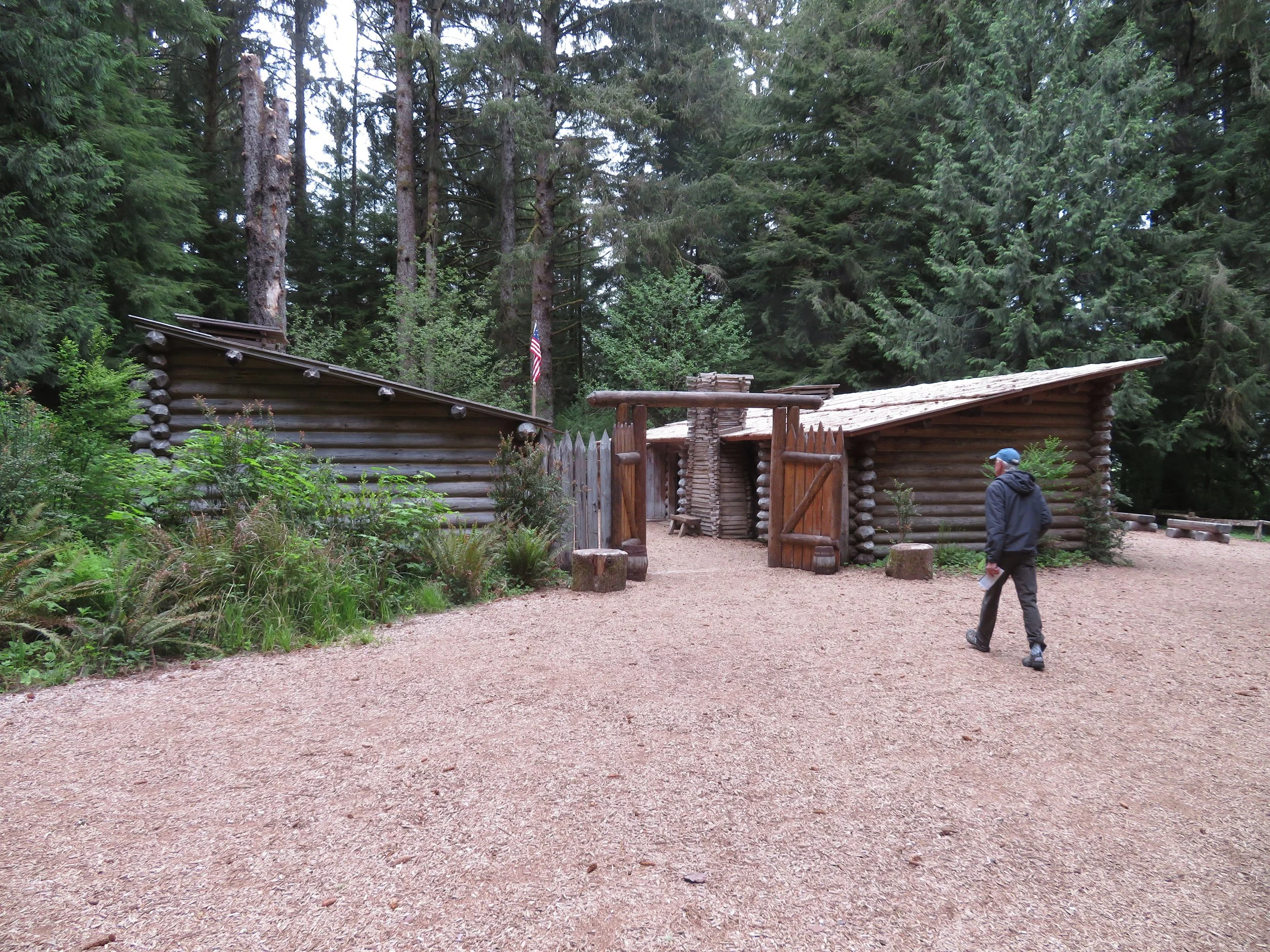
The park’s location on the banks of the Netul River, now the Lewis & Clark River, is located in Warrenton, Oregon, just outside of Astoria. The replica Fort Clatsop, named after the local Clatsop Indian tribe, was built largely from a floor plan complete with dimensions that Clark drew on the elkskin cover of one of his journals. Clark was the cartographer of the group and Lewis, the naturalist. Together with their troupe, they were an awesome team.
Unbeknownst to us previously, York, Clark’s black manservant (slave) traveled with the group, purportedly as an equal and contributed significantly to the expedition. There’s much debate and speculation about York’s life after the expedition, but one story alleges that he went back West to live with the Crow tribe and was highly respected. Lewis’s Newfoundland dog, Seaman also went along for the trip and probably didn’t contribute much at all.
We watched an excellent introductory film at the Visitor Center then toured the small museum before heading out on one of the many trails through the park.

The Fort to Sea Trail from Fort Clatsop to the historical salt works on Sunset Beach was 13 miles round trip, a bit too long for our purposes. We walked a part of it on a crushed rock trail and then detoured onto the South Slough Trail and then along the river for a total of about 4 miles.

David spotted this giant slug on the path. Our iNaturalist app identified it as a banana slug. He moved ‘at a snail’s pace’ probably because of the weight of the pine needles stuck to his slimy butt.

Sitka spruce and red cedar trees towered above us… not giant redwoods, but still 150-200’ tall.

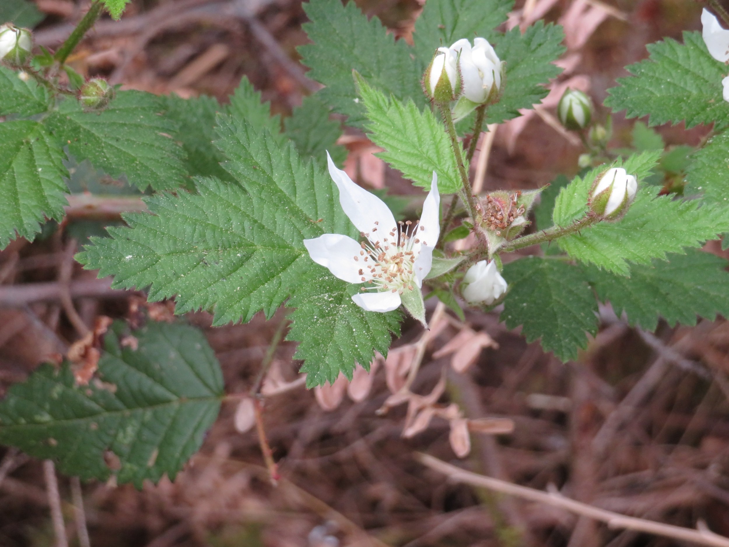
Candy flower, trailing blackberry, Pacific waterleaf, western lily of the valley… wildflowers were prolific in this lush forest setting.


We stopped in the touristy, but cute town of Seaside on the return trip to the campground. A large statue entitled ‘End of the Trail’ sits at the Pacific oceanside and memorializes Lewis & Clark’s expedition.


A bowl of clam chowder and a fresh brew at Doogers topped off the day before heading back to the campground.

Day 19 - Powering Up & Into Washington
The new house batteries that David ordered arrived and we picked them up this morning. While I restocked the larder at Walmart and caught up on my journal, David installed them. He’ll talk more about them in his next blog, but 2-1/2 hours after picking them up, we were on the road again with a fresh power supply. He’ll tell you all about it in his next Blue View.
We drove over the mighty Columbia River on the Astoria-Megler Bridge and entered Washington state. A huge bulk carrier traveled under the bridge, fully laden, and heading out to sea.

US-101 continues along the scenic shores of the Willapa Bay separating the mainland from the Long Beach peninsula and the Pacific. We stopped at Cape Disappointment State Park to visit Cape Disappointment Light. Lewis & Clark visited this area, not disappointed at all, because they’d finally reached the Pacific Ocean. It was a British fur trader, John Meares, who named the cape after mistaking the mouth of the Columbia for a bay and, being unable to locate the river at all, claimed previous explorers who had mapped the area to be all wrong.
The .6 mile trek on a rough trail to the lighthouse was steep in parts with lots of ups and downs. The views of Deadman’s Cove below were great.

The lighthouse itself was in desperate need of some TLC. The lighthouse is still in use by the Coast Guard as a lookout over the entrance to the Columbia River.

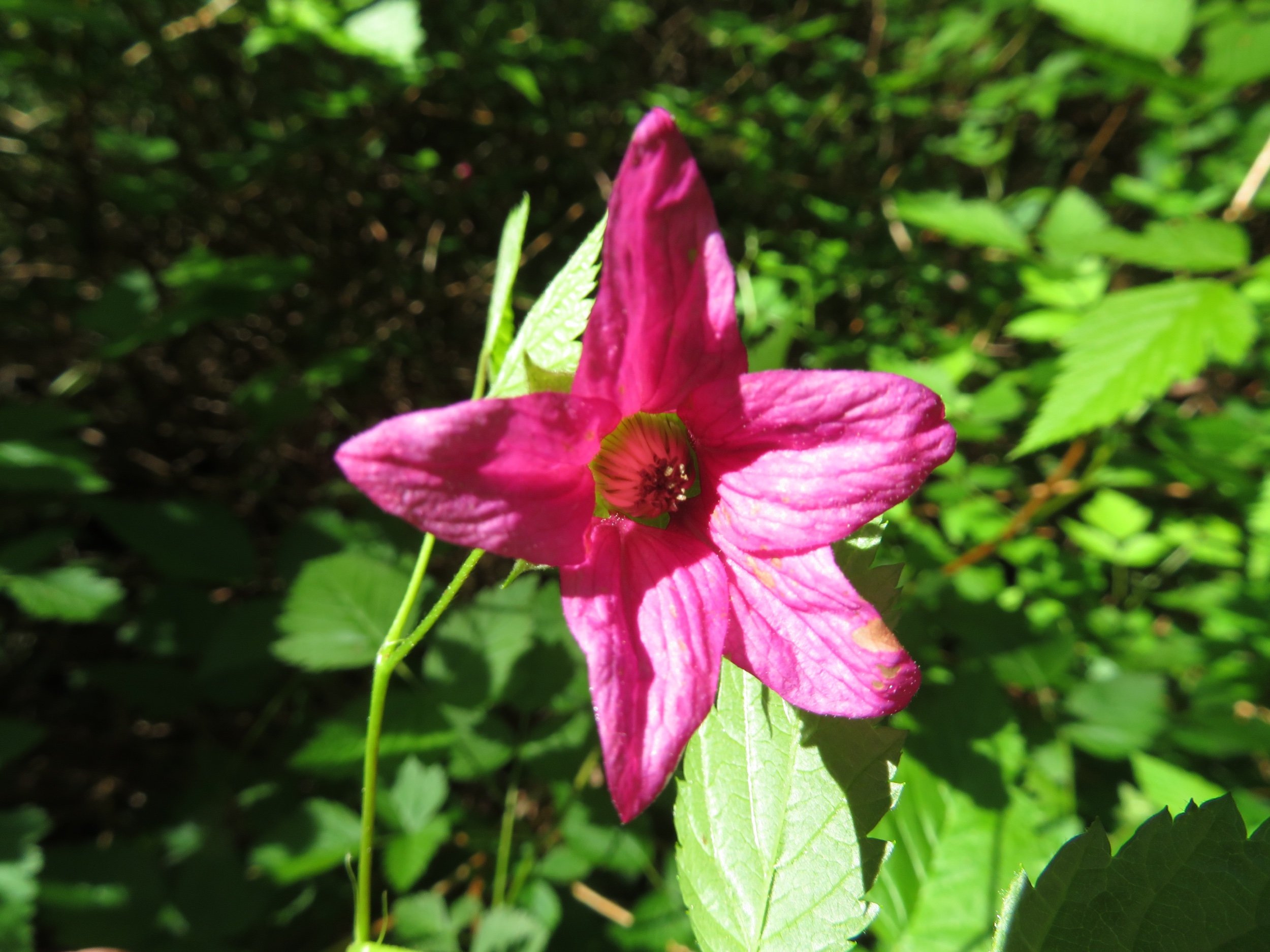
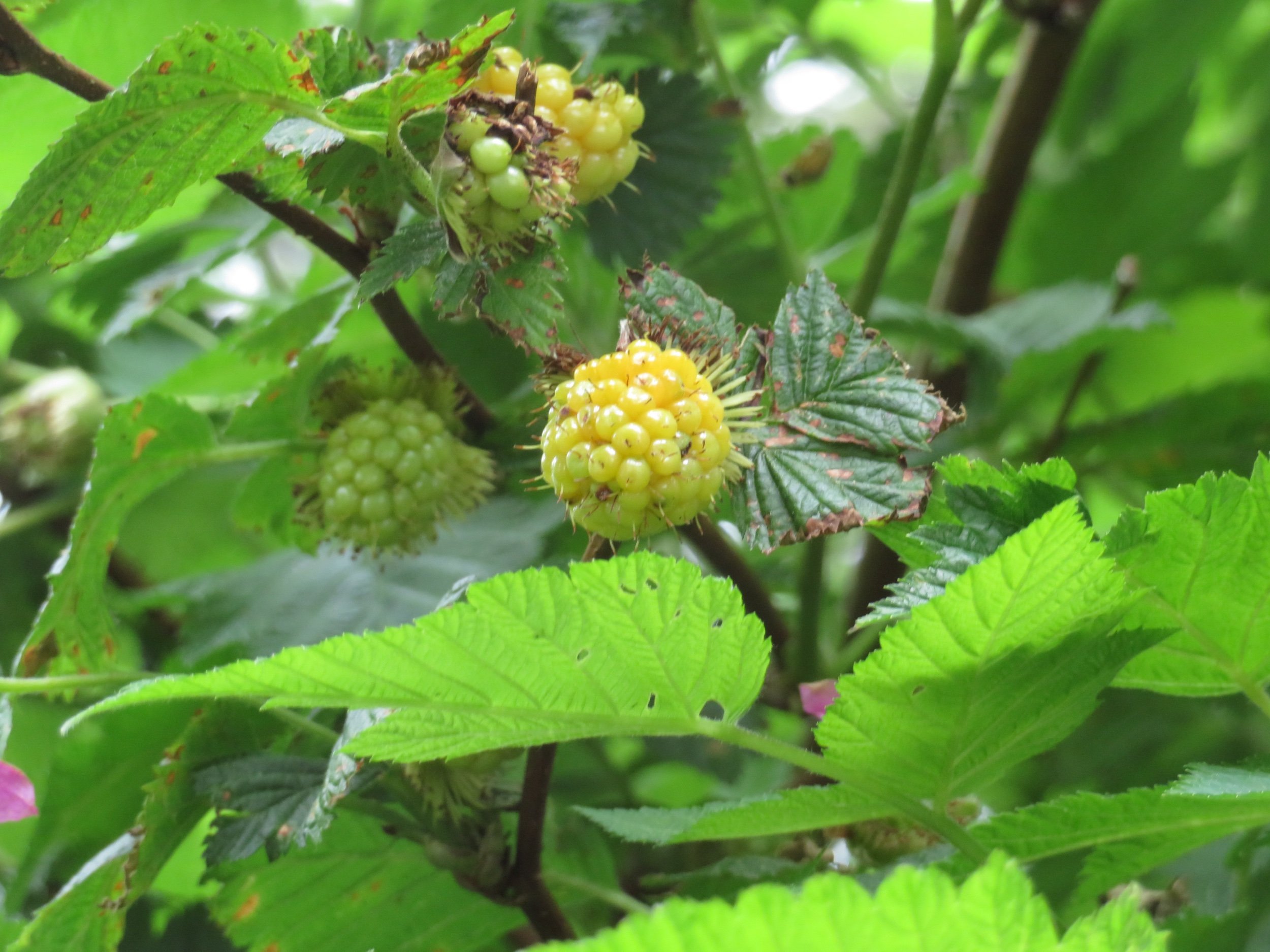
We’d identified deep pink salmonberry flowers previously, but had never seen the yellow berries which looked almost ready to eat. We’re told they taste like raspberries.
In order to park at the lighthouse trailhead, we needed to purchase a Discover Pass, daily entry to Washington State Parks, for $10, which we gladly paid to support the state park system. The pass also allowed us access to nearby North Head Light, so why not?

The entrance to the Columbia River over the treacherous Columbia Bar has come to be known at ‘the Graveyard of the Pacific’. After the construction of the Cape Disappointment Light, shipwrecks continued because ships traveling from the north could not see the light. Hence, North Head Light was built two miles north in 1898 and is still functional today.

Lodging is available in two buildings on the lighthouse grounds and though it was too late for us to make reservations, we thought it would have been fun to stay there.

Aberdeen considers itself ‘the Lumber Capital of the World’ as well as the ‘Gateway to Olympic’. They did have a Walmart and we stopped. They do not allow overnight stays in their parking lot. Too much abuse by past overnight campers… BAH! Just beyond Aberdeen in Hoquiam, we found the Hoquiam River RV park. For $53/night, they offered all the hookup amenities which we didn’t need, but our spot overlooking the river was pleasant enough. We took advantage of a network of trails through their 10 acres of land. We had no cell coverage once again (ATT and Verizon where are you?) and the park’s Wi-Fi was maddeningly slow, but with patience, allowed us to at least read the daily news.

Next time, Olympic National Park and then into British Columbia, Canada! Hooray! Come with us!