

Cape Breton, Nova Scotia
/“Céad míle fáilte”
We boarded the M/V Highlanders ferry to Nova Scotia quickly and efficiently. Blanche safely in her space, we grabbed whatever we thought we’d need for the 6+ hour planned passage and headed up the stairs to Deck 9 and our reserved seats. No one is allowed to stay in or access their vehicles once the ferry is underway. We were pleasantly surprised at how plush and comfy the seats were with reclining backs, footrests and lots of room… an invitation to nap en route.

Loading vehicles into the bowels of the M/V Highlanders was quick and efficient.
As we departed Port aux Basque the fog moved in. Our previous view of the Channel Head Light became dimmer and dimmer until we couldn’t see it at all.

Channel Head Light disappeared in the fog

Until we couldn’t see it at all
Once away from the port, however, the fog cleared and the day was bright and sunny. We took a turn or two on the observation deck and wandered around the various parts of the ship open to passengers just to stretch our legs.

Heading into Sydney Harbour
We were surprised when we heard the announcement that we were nearing Sydney, Nova Scotia after only 4-1/2 hours. We gathered our belongings and headed back to Blanche only to discover we’d left our phone back at our seat. I ravaged through my pack and David’s in hopes it’d turn up, but nope, we’d left it behind. David dashed back up six flights to get it while I explained to a very understanding ferry official our predicament. ‘No worries’, he said. David returned just in the nick of time as our row of vehicles began disembarking. The ferry official had been watching and gave us the thumbs up. Whew!
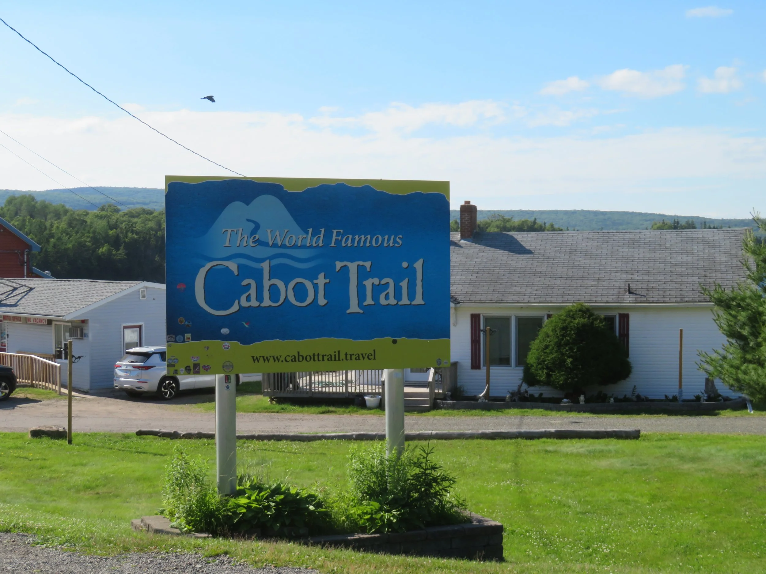
We’d been unable to obtain a Nova Scotia road map in all our travels. Yes, we do use GPS in Blanche and on our phone for navigating on our trips, but we still prefer road maps when we do our planning. We headed towards Cape Breton Highlands National Park and the Cabot Trail based on local signs.
We were definitely in Nova Scotia (New Scotland). Many of the signs are in English and Gaelic along with a céad míle fáilte (pronounced kayd milla fawlcha - a hundred thousand welcomes) or two to emphasize the point. In 1621 King James VI of Scotland (King James I of England) granted Sir William Alexander all the land between current day New England and Newfoundland. Quite the chunk of real estate which most assuredly warranted the territory be named after his homeland.


The Cabot Trail, named after the famous explorer, John Cabot is one of Canada’s most famous road trips. It’s a 185-mile (298 km) loop drive along coastal Nova Scotia offering stupendous views of both coasts and access to lots of neat little towns and villages. We picked it up near St. Ann’s and began the drive north.
Beyond the scenery, there are so many shops along the route… Celtic quilts, pewter, glassblowing, ironworks, woolen goods, art galleries, restaurants, boutiques, souvenir shops. It was late in the afternoon when we passed them and most were closed for the day. I could hear David breathe a sigh of relief. We found a place to park near an old quarry for the night. It was quiet, off the road and absolutely abounded in daisies!

The morning dawned gray and overcast with a high probability of rain in the forecast. We headed out with the best of intentions to do some hiking. Just south of Ingonish we came across St Peter’s Church, a surprisingly majestic for a small town in the Cape Breton Highlands.

St. Peter’s Catholic Church in Ingonish in the rain
We entered the Cape Breton Highlands National Park without much fanfare. No big signs, no big visitor center, just an entry fee collection station that checked our annual pass and provided a map.

With ~151,000 miles (243,000 km) of coastline, Canada’s ocean shoreline is the longest in the world and it has more lakes than the rest of the world combined. Canada is also home to more than 750 lighthouses and long range lights on three oceans and the Great Lakes. We picked up a copy of Nova Scotia’s lighthouse list and map at an info kiosk that showed 61 that we could possibly see. We stopped in Neil’s Harbour for a look at our first Nova Scotia lighthouse. As is many times the case, lighthouses look more appealing from afar than they do up close.

Neil’s Harbour Light rising above the harbor

Up close, the lighthouse didn’t seem quite as majestic
A bit further along the route, we saw a sign for St. Paul Island Heritage Lighthouse. St. Paul was Canada’s first federally designated ‘heritage lighthouse’. Built in 1915, this lighthouse was also the first cast iron lighthouse built in Canada. It was relocated to Dingwall (yup, Dingwall) in 2010. Though renovated, it wasn’t very impressive perhaps because of its size. It’s rather small. Or perhaps because it was not located near the water. The museum beside it was open and we wandered around for a bit, then found our way back to the Cabot Trail.

St. Paul Island Heritage Lighthouse
Last night’s rain continued off and on throughout the day… sometimes just cloudy, sometimes showers , mostly drizzle. We checked out the park map for shorter hikes and settled first on the Lone Sheiling, a half mile (.6km) loop trail through 350 year old maple trees to a replica of a stone Scottish shepherd’s hut.

David in his head net explores the Lone Shielding, a replica stone shepherd’s hut
We weren’t alone on the trail. We wore our head nets and slathered with insect repellent. There are 108+ recorded species of biting, flying insects in the Maritimes including midges, black flies, horse flies, mosquitoes, deer flies, sandflies… oh, the list goes on and on… based on a doctoral thesis by D. J. Lewis. I swear we’ve been bitten by each and every one of them at least once!
By the time we reached The Bog, our next hiking choice, it was drizzling constantly and breezy, but the mosquitoes seemed to have abated. Located at the top of French Mountain, a boardwalk trail meandered through a high plateau bog (not a marsh, not a fen, not a swamp, but a bog!). The wildflowers here were absolutely awesome… orchids, pitcher plants, rue… take a look!


The last and longest trail of the day was the Skyline Trail and we resigned ourselves to walking it in a drizzly, light rain. We donned our raincoats and set out along this level, gravel and boardwalk loop trail planning to walk its length of ~5 miles. The trail was lined in fragrant honeysuckle and ferns.


A fenced area was a moose ‘exclosure’ designed to keep moose out of an area of recovering boreal forest the park service was attempting to protect from an over abundance of moose browsing in the area.

A fenced moose exclosure helped protect a recovering boreal forest
The light rain intensified to a heavy rain and the fog moved in. Feeling like drenched rats, we opted to turn around and return to the parking lot. In actuality, we ended up walking ~4 miles roundtrip and not seeing the headland. We could have just as easily stayed on the trail for another drenching mile to finish the loop, but our chances of seeing anything in the rain and fog were minimal. We were glad to get into Blanche, dry off and warm up.
Continuing along in the intermittent rain, the views of the road ahead from our elevated vantage point were great.

The Cabot Trail appears to be a ribbon of road along the coast.

Rugged cliffs along the cabot Trail coast
Somewhere since the previous night and along the day’s route, we noticed the fridge was constantly running. A quick inspection also indicated the inside fridge temp was quite similar to the ambient temp outside the fridge. Grrrrrr… the fridge is barely a year old. It was a Saturday night and we weren’t close to any place that we thought could fix it. We bought some ice and turned the fridge into a cooler. We’d handle the fridge problem on Monday.
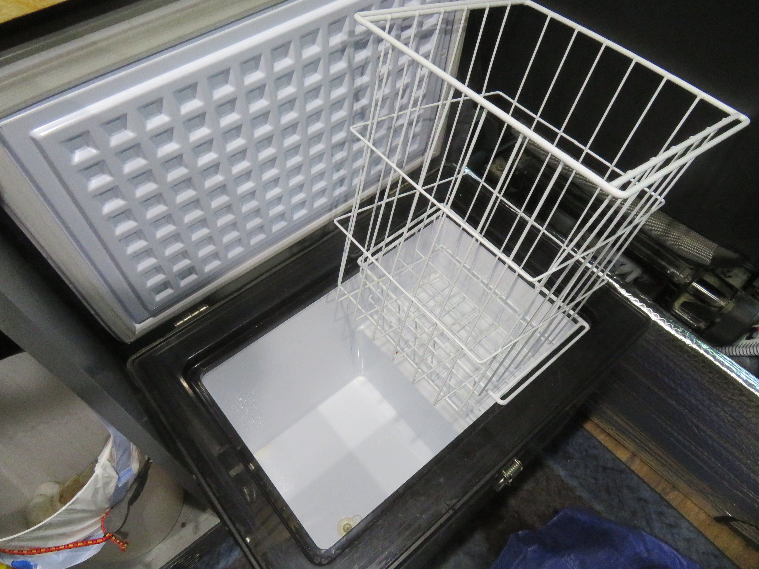
We emptied the fridge, cleaned it out and got rid of the food that had spoiled then bought ice and turned it into a cooler.
Out of the national park boundary now, but still on the Cabot Trail, we found a free RV parking area overlooking the ocean on Cheticamp Island for the night. The rain never let up, but on the positive side, Blanche received a much-needed shower.

After a quiet, wet night, we woke to yet another gray, foggy, drizzly day as we continued our way south down the Cape Breton’s west coast. We stopped at a visitor center in Inverness looking for possible activities on a rainy day. We picked up a brochure on Sunday farmer’s markets with a recommendation from the young volunteer of a particularly lively market in Mabou. We headed that way.

The Mabou market was well-signed and indeed a lively one held in a large indoor community hall. The muddy, puddled parking lot was jam-packed full, but we lucked out on a parking spot as one market goer was just backing out.
The market was in full swing when we arrived with lots of vendors and lots of attendees. We made a tour around and admired the food and crafts on offer. On our second swing around, we purchased a quilted table runner from Jean Macdonald’s impressive display and an interesting blueberry liqueur from the local Glenora Distillery. We also snagged a couple of quiches for lunch which provided indigestion for the rest of the day.
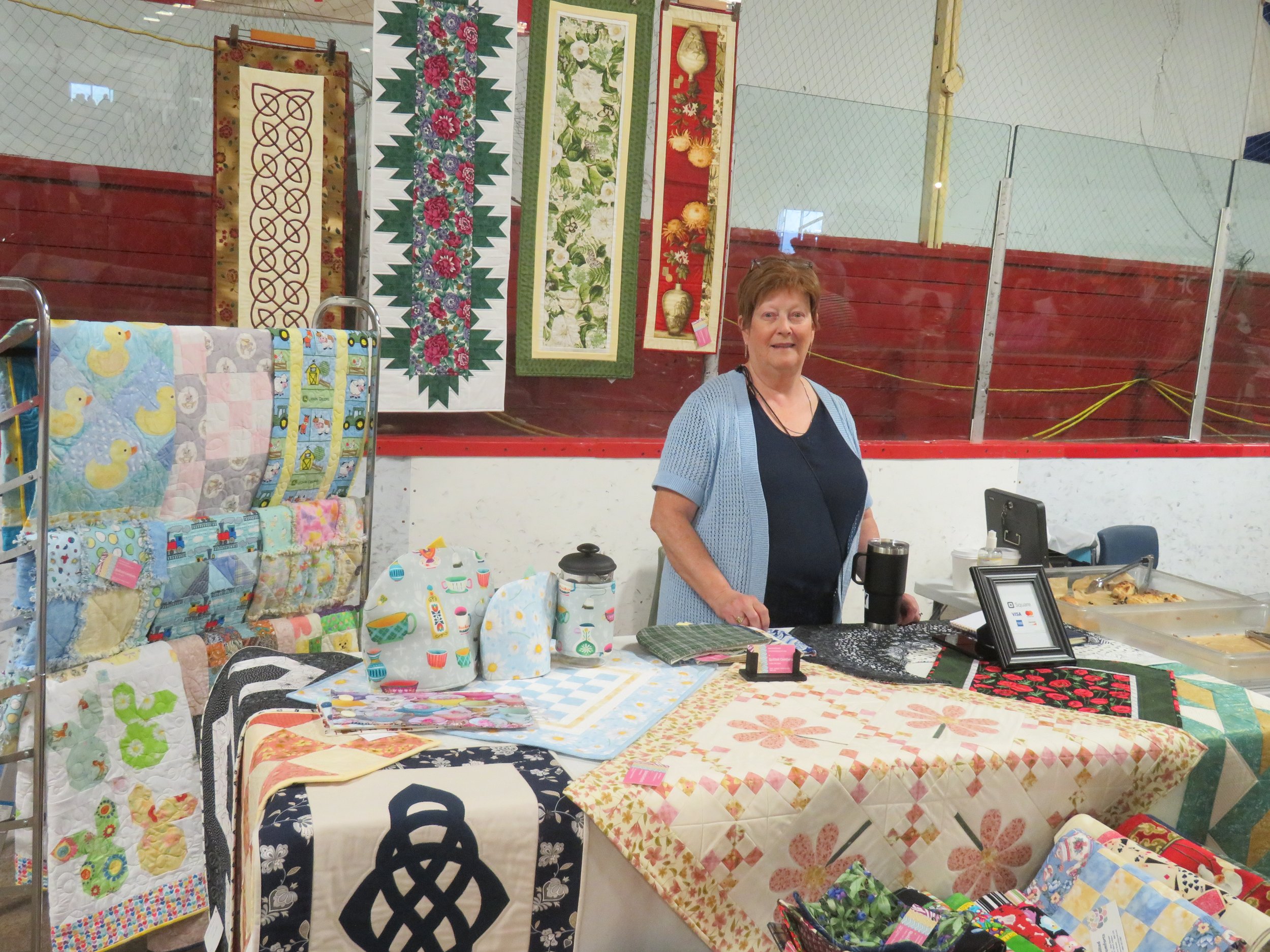
We purchased a quilted table runner from Jean MacDonald at the Mabou Farmer’s Market.
We’d turned off the fridge overnight in hopes it might work in the morning… maybe the lines had frozen up? It did work… for about an hour… then crapped out again. It needed attention. Reluctantly, we left Cape Breton and headed across the Canso Passage towards Halifax where we hoped to find a repairman.
Next time, Marine Drive on Nova Scotia’s Eastern Shore, a fridge repair and a totally impractical meandering route to the Fundy Shores. Come join us!
Check out the map below to see our route in Nova Scotia thus far.
