

A Bit More Scotia and A New Plan
/
The Canso Causeway from Cape Breton to Eastern Shore Nova Scotia
The Canso Causeway connects Cape Breton with the rest of Nova Scotia. We crossed from Cape Breton and since we had to wait till Monday before David could try to locate a repairman for the fridge, we headed along the coastal route called Marine Drive on Nova Scotia’s Eastern Shore for a more scenic trip to the big city. We spent the night in Guysborough Municipal Park overlooking Chedabucto Bay. The gravel parking lot had great views, picnic tables and disgusting porta-potties (full and yucky), but it was free, quiet and peaceful and we, thankfully, have our own toilet.

View of Chadabucto Bay from our overnight site in guysborough

The views along Marine Drive were great… until they weren’t.
We continued along Marine Drive heading west towards Dartmouth/Halifax. David had tried making a few phone calls during the day with no success. We’d done everything we could think of to troubleshoot possible issues, but nothing seemed to work.
Marine Drive was potentially gorgeous, but we couldn’t say because it was so foggy, we saw virtually nothing of the coast.

Once the fog rolled in, the coastal views disappeared
We noted so many little white churches, small parish graveyards in front or beside them, each serving its own small community. We were in an Acadian region of Nova Scotia and the churches and French names attested to the Acadian culture. Nouvelle Ecosse (New Scotland) is what they call Nova Scotia.

We passed through small historic villages… Whitehead est. 1718, Charlas Cove est. 1799, Issac’s Harbour est. 1760. We drove over one-lane plank bridges. Tiny ponds with yellow lilies and small quiet coves made us reminisce about sailing this area with Nine of Cups. It’s peak season here in Nova Scotia and yet the roads here are empty with little to no traffic.
At Issac’s Harbour, we had a surprise. We hadn’t noted on the map that this was a ferry crossing. The cable ferry M/V Theodore O’Hara runs every half hour between 7am-6pm, then on demand. We could see the ferry on the opposite side of the harbor… a stone’s throw away. We waited about 10 minutes and sure enough, the ferry docked and we boarded for the 5-minute ride to the opposite shore.


Just down the road from the ferry, we stopped for a porcupine leisurely crossing the road.

He seemed to be in no particular hurry, but refused to pose for photos.
The fog cleared briefly… wisps of mist sailed across the road. Then it returned… an opaque wall of white. Again, we were reminded of our time here in 2001 aboard Nine of Cups. The fog would close in and envelope us… so thick, it was claustrophobic. All sound was muffled. Buoy bells and fog horns sounded in the distance, barely audible. Creeping along blindly. Ah, the good old days.
We found a campsite for the night at Porter’s Lake Provincial Park. The fog had dissipated once again and we sat outside on a warm, sunny early evening. We steamed some mussels, ate a few and used the remainder of them and their broth to make a chowder for dinner. All too soon the fog rolled in once again. We packed up and climbed back into Blanche.
We’d been buying ice every day to keep what food we had left cool. It wasn’t ideal, but getting the fridge fixed seemed nearly impossible. I would have given up in frustration, but David persevered and after a zillion “sorry, we can’t help” responses, he finally found a mobile guy to come to us in a Walmart parking lot in Dartmouth. $200 later and an injection of freon, the fridge was cooling like a champ.
Though we rarely make schedules, we had made reservations to celebrate our 40th anniversary and David’s birthday in Charlottetown, Prince Edward Island (PEI). We thought we’d allotted enough time in Nova Scotia, but we obviously had not, especially with the fridge delay. We still had a couple more days to spend exploring Nova Scotia until the reservation date. We decided to head slowly in the general direction of PEI and see what we could see along the way. We would return to Nova Scotia afterwards. Not the most efficient or direct plan by any measure, but we’d make it work.
We began heading north on backroads towards Truro when a sign in South Maitland for the Fundy Tidal Interpretive Centre caught our attention. Strategically located beside the Shubenacadie River (the Shubie), one of the longest rivers in Nova Scotia, the Centre is known for its tidal bore viewing.
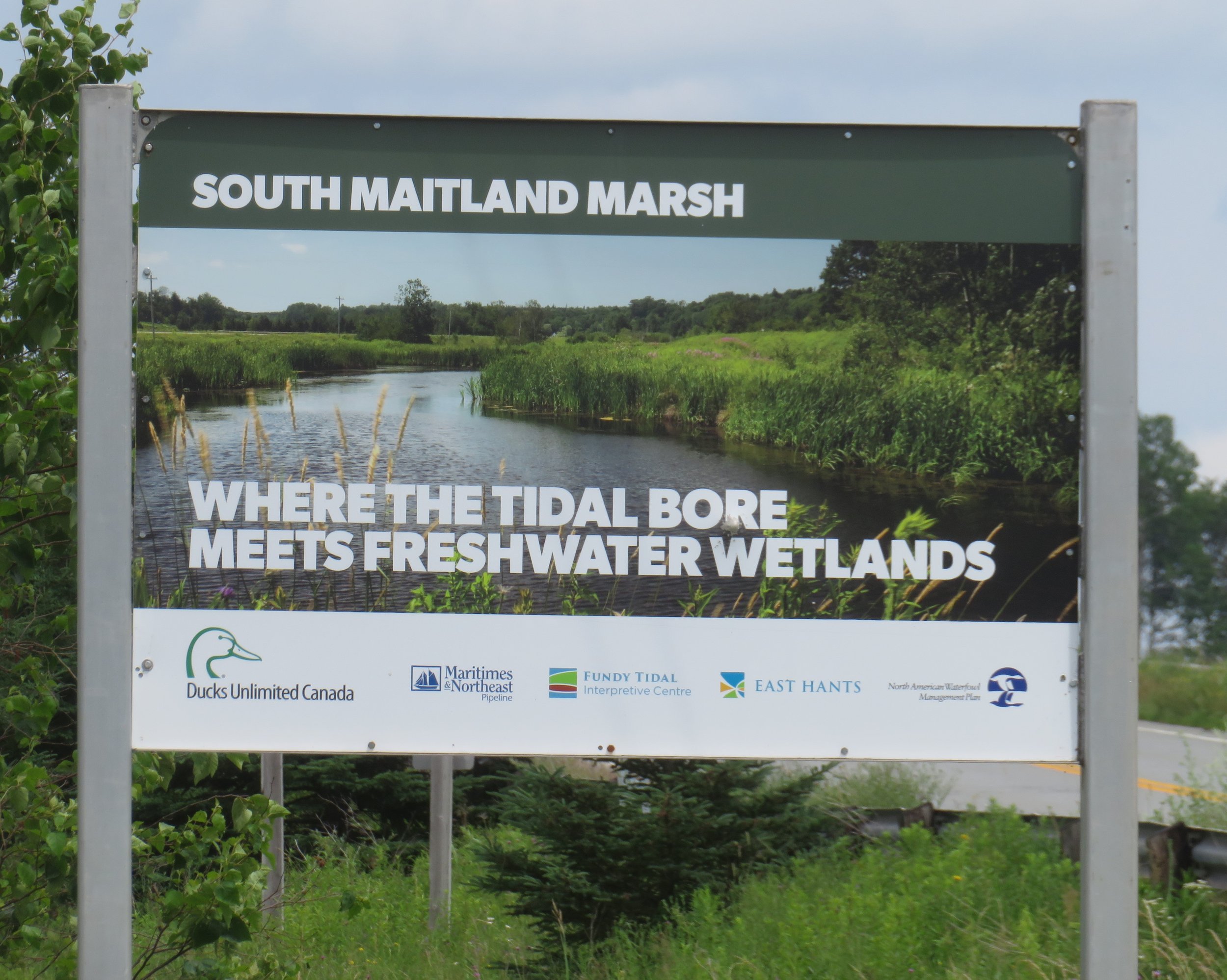
Tidal bores are formed when a river flow reverses its direction due to the mighty force of the tide rushing in and opposing it. In this case, the Fundy tides, the biggest tides in the world, rush up the Cobequid Basin and into the Shubie River. We had no idea of the tide schedule, but thought we’d check out the Centre anyway. As luck would have it, we arrived at exactly the right time for the South Maitland Marsh Tidal Bore.
It was a hot, hazy, humid 90F (32.2C) as we walked down the path towards the tidal bore viewing area.

Hot and hazy pathway to a lookout over the Shubie river
There were 20 or 30 other folks waiting patiently in the sun for the ‘event’. A volunteer docent provided commentary and told us what to look for as the change in tide occurred… a mini wave heading upriver.
The water churned. Eddies formed. The muddy river flowing into the sea was overtaken by the tidal rush… slowly at first, then the tidal force overwhelmed it and it was pushed backwards as it succumbed to the tide. It happens twice a day like clockwork every 12 hours and 26 minutes. Pretty cool to watch.


In Truro, we picked up the Glooscap Trail, named after the legendary creator figure of the Wabanaki people.

Heading west along the northern coast of the Minas Basin, we found an outstanding campsite at Five Islands Provincial Park overlooking the Basin. A great spot for watching the Fundy tides which we hoped to do in the morning. The only issue with the campground… no potable water.

Our campsite overlooked the Minas basin
We awoke the next morning to pea soup fog with nary a view of the Basin below us. We found a parking spot and followed a trail down to the shore. It was low tide and we walked for nearly a mile over the rocky, sometimes muddy ocean floor.


We continued on the Glooscap Trail and in Parrsboro had the opportunity to meet up with Glooscap himself, standing proud and tall in a park, his hair blowing in the wind.

Glooscap was somewhat intimidating. These little girls were frightened at first, then curious.
We were getting anxious to get to PEI and headed north bound for New Brunswick. Just over the provincial border, we saw the signs for the Confederation Bridge… the gateway to Prince Edward Island and we headed for the bridge.

Next time… Across the bridge to Prince Edward Island. Woohoo!
Below, see our route from Cape Breton along Marine Drive and up to the Confederation Bridge entrance to Prince Edward Island. There’s so much more of Nova Scotia to see and we promise we’ll be back.
